Trams in Düsseldorf
 A Düsseldorf tram at Graf-Adolf-Platz. | |||||||||||||||||||||||
| Operation | |||||||||||||||||||||||
|---|---|---|---|---|---|---|---|---|---|---|---|---|---|---|---|---|---|---|---|---|---|---|---|
| Locale | Düsseldorf, North Rhine-Westphalia, Germany | ||||||||||||||||||||||
| |||||||||||||||||||||||
| |||||||||||||||||||||||
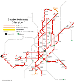
The Düsseldorf tramway network (German: Straßenbahnnetz Düsseldorf) is a network of tramways serving Düsseldorf, the capital city of the federal state of North Rhine-Westphalia, Germany. In combination with the Düsseldorf Stadtbahn and Rhine-Ruhr S-Bahn, it forms the backbone of the public transport system in Düsseldorf.
The tramway network is currently operated by Rheinbahn AG. As of 2016, its seven tram lines ran over 78.0 kilometres (48.5 mi) of route, serving 178 stops.[1]
History
In 1876, the first horse-drawn tram line opened in Düsseldorf, joining Castle Square with the Bergisch- Märkischen station and the concert hall.[2] In 1896, the first electric tram ran in Düsseldorf,[2] and the full conversion of the system to electricity continued through 1900.[2]
Lines
As of 2016, seven tram lines[1] running on 78.0 kilometres (48.5 mi) of route,[1][1] operate in the city of Düsseldorf and in portions of the urban areas of Neuss:
| Line | Route | Stops | Run time | Takt Mo.–Fr./Sa./Su. |
|---|---|---|---|---|
| 701 | (ISS Dome (under construction)) – D-Rath |
28 | 35 min | 10/10/15 (20/20/30) |
| 704 | Merziger Straße – Straßburger Straße – Alter Schlachthof – Rather Straße / Hochschule HSD – St.-Vinzenz-Krankenhaus – Lennéstraße – Stockkampstraße – Rochusmarkt – Adlerstraße – Pempelforter Straße |
21 | 29 min bis Uni Nord / 30 min bis Botanischer Garten | 10/15/15 (-/-/15) |
| 705 | D-Unterrath |
32 | 43 min | 10/10/15 (20/20/30) |
| 706 | D-Hamm |
35 | 51 min | 10/15/15 |
| 707 | D-Unterrath |
29 | 43 min | 10/10/15 |
| 708 | Heinrichstraße – Hansaplatz – Grunerstraße – Brehmplatz – Schillerplatz – Uhlandstraße – Birkenstraße – Worringer Platz – Hauptbahnhof |
15 | 23 min | 20/-/- |
| 709 | Gerresheim, Krankenhaus – Heinrich-Könn-Straße – Auf der Hardt / LVR-Klinikum – Pöhlenweg – (Grafenberg, Staufenplatz) – Burgmüllerstraße – Schlüterstraße / Arbeitsagentur – Engerstraße – Hoffeldstraße – D-Flingern |
33 | 54 min | 10/10/15 (20/20/30) |
After finishing work at the Wehrhahlinie, many of the tram lines (703, 712, 713 and 715) have been moved to the new Stadtbahn service.
Current fleet
The current tram fleet is a mix of older trams from Duewag, and new trams from Siemens.
See also
- Düsseldorf Stadtbahn
- Rhine-Ruhr S-Bahn
- Rhein-Ruhr Stadtbahn
- Verkehrsverbund Rhein-Ruhr
- List of town tramway systems in Germany
- Trams in Germany
References
Notes
- 1 2 3 4 5 6 7 "Zahlenübersicht Stand 31. Dezember 2012" [Figures Summary as of December 31, 2012] (PDF) (in German). Rheinbahn. December 31, 2012. p. 7. Retrieved 2013-10-19.
- 1 2 3 "1920: Das Ende der Düsseldorfer Straßenbahn" [1920: The end of the Düsseldorf tram [company]] (in German). Rheinbahn. Retrieved 2013-10-19.
Bibliography
- Höltge, Dieter (1994). Straßen- und Stadtbahnen in Deutschland [Tramways and Stadtbahnen in Germany] (in German). Band 4: Ruhrgebiet - Von Dortmund bis Duisburg [Volume 4: Ruhr - from Dortmund to Duisburg]. Freiburg i. B., Germany: EK-Verlag. ISBN 9783882553345.
- Nolden, Hans G (1998). Die Düsseldorfer Straßenbahn [The Düsseldorf Tramway] (in German). München: GeraMond Verlag. ISBN 3932785029.
- Schwandl, Robert (2012). Schwandl's Tram Atlas Deutschland (in German and English) (3rd ed.). Berlin: Robert Schwandl Verlag. pp. 46–48. ISBN 9783936573336.
External links
| Wikimedia Commons has media related to Trams in Düsseldorf. |
- Rheinbahn - official site (German)
- Rheinbahn - official site
- Düsseldorf network map (pdf)
- Düsseldorf database / photo gallery and Düsseldorf tram list at Urban Electric Transit – in various languages, including English.
- Düsseldorf database / photo gallery at Phototrans – in various languages, including English.
| Baden-Württemberg |  | |
|---|---|---|
| Bavaria | ||
| Berlin | ||
| Brandenburg |
| |
| Bremen | ||
| Hesse | ||
| Lower Saxony | ||
| Mecklenburg-Vorpommern | ||
| North Rhine-Westphalia | ||
| Rhineland-Palatinate | ||
| Saarland | ||
| Saxony | ||
| Saxony-Anhalt | ||
| Thuringia | ||
| ||
Urban public transport networks and systems in Germany | ||
|---|---|---|
| S-Bahn |    | |
| U-Bahn | ||
| Stadtbahn | ||
| Trams |
| |
| Trolleybuses | ||
| Suspension monorails | ||
| Other | ||
| ||
Coordinates: 51°14′N 06°47′E / 51.233°N 6.783°E