Toumodi Department
| Toumodi Department Département de Toumodi | |
|---|---|
| Department | |
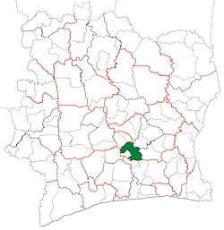 Location in Ivory Coast. Toumodi Department has had these boundaries since 2012. | |
| Country |
|
| District | Lacs |
| Region | Bélier |
| 1988 | Established as a first-level subdivision via a division of Bouaké Dept |
| 1997 | Converted to a second-level subdivision |
| 2011 | Converted to a third-level subdivision |
| 2012 | Divided to create Djékanou Dept |
| Departmental seat | Toumodi |
| Government[1] | |
| • Prefect | Gando Coulibaly |
| Area[2] | |
| • Total | 2,837 km2 (1,095 sq mi) |
| Population (2014)[3] | |
| • Total | 127,825 |
| • Density | 45/km2 (120/sq mi) |
| Time zone | GMT (UTC+0) |
Toumodi Department is a department of Bélier Region in Lacs District, Ivory Coast. In 2014, its population was 127,825 and its seat is the settlement of Toumodi. The sub-prefectures of the department are Angoda, Kokumbo, Kpouèbo, and Toumodi.
History
.jpg)
Toumodi Department was created in 1988 as a first-level subdivision via a split-off from Bouaké Department.[4]
In 1997, regions were introduced as new first-level subdivisions of Ivory Coast; as a result, all departments were converted into second-level subdivisions. Toumodi Department was included in Lacs Region.
In 2011, districts were introduced as new first-level subdivisions of Ivory Coast. At the same time, regions were reorganised and became second-level subdivisions and all departments were converted into third-level subdivisions. At this time, Toumodi Department became part of Bélier Region in Lacs District.
In 2012, two sub-prefectures were split from Toumodi Department to create Djékanou Department.[5]
Notes
- ↑ "Préfets de Région et de Préfets de Département (Conseil des ministres du mercredi 26 septembre 2012)", abidjan.net, 2 October 2012.
- ↑ "Monographie du département de Toumodi", abidjan.net, 12 December 2013.
- ↑ "Côte d'Ivoire". geohive.com. Retrieved 5 December 2015.
- ↑ "Regions of Côte d'Ivoire (Ivory Coast)", statoids.com, accessed 16 February 2016.
- ↑ "Le décret n° 2012-611 du 04 juillet 2012 portant création des Départements de Djékanou, Sipilou, Kong, Gbéléban, Taabo, Kouassi-Kouassikro, Méagui, Séguélon, Buyo, M'Bengué, Facobly et Dianra".
Regional seat: Yamoussoukro | ||
| Didiévi Department |  | |
| Djékanou Department | ||
| Tiébissou Department | ||
| Toumodi Department | ||
* also a commune | ||
Coordinates: 6°55′N 5°3′W / 6.917°N 5.050°W