Haut-Sassandra
| Haut-Sassandra Region Région du Haut-Sassandra | ||
|---|---|---|
| Region | ||
| ||
| Motto: "Cohésion, travail, développement" | ||
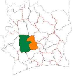 Location of Haut-Sassandra Region (green) in Ivory Coast and in Sassandra-Marahoué District | ||
| Country |
| |
| District | Sassandra-Marahoué | |
| 1997 | Established as a first-level subdivision | |
| 2000 | Divided to create Fromager Region | |
| 2011 | Converted to a second-level subdivision | |
| Regional seat | Daloa | |
| Government[1] | ||
| • Prefect | Kouamé Brou | |
| • Council President | Alphonse Djedje Mady | |
| Area[2] | ||
| • Total | 17,761 km2 (6,858 sq mi) | |
| Population (2014)[3] | ||
| • Total | 1,430,960 | |
| • Density | 81/km2 (210/sq mi) | |
| Time zone | GMT (UTC+0) | |
| Website |
crhs | |
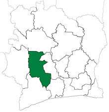
Haut-Sassandra Region is one of the 31 regions of Ivory Coast and is one of two regions in Sassandra-Marahoué District. The region's seat is Daloa. The region's area is 17,761 km²,[2][4] and its population in the 2014 census was 1,430,960,[3] making it the most populous region of Ivory Coast.
Departments and geography
Haut-Sassandra is currently divided into four departments: Daloa, Issia, Vavoua, and Zoukougbeu.
The region is traversed by a northwesterly line of equal latitude and longitude.
History
Haut-Sassandra Region was created in 1997 as a first-level administrative region of the country. In 2000, Gagnoa Department was split off from Haut-Sassandra and combined with Oumé Department from Marahoué Region to form Fromager Region.
As part of the 2011 administrative reorganisation of the subdivisions of Ivory Coast, Haut-Sassandra was converted into a second-level administrative region and became part of the new first-level Sassandra-Marahoué District.[5] No territorial changes were made to Haut-Sassandra as a result of the reorganisation.
Notes
- ↑ "Préfets de Région et de Préfets de Département (Conseil des ministres du mercredi 26 septembre 2012)", abidjan.net, 2 October 2012.
- 1 2 "Haut-Sassandra", gouv.ci, accessed 23 February 2016.
- 1 2 "Côte d'Ivoire". geohive.com. Retrieved 5 December 2015.
- ↑ Since 2000. From 1997 to 2000, the area was greater.
- ↑ Décret n° 2011-263 du 28 septembre 2011 portant organisation du territoire national en Districts et en Régions.
Coordinates: 7°0′N 6°30′W / 7.000°N 6.500°W
.jpg)
Regional seat: Daloa | ||
| Daloa Department | | |
| Issia Department | ||
| Vavoua Department | ||
| Zoukougbeu Department | ||
* also a commune | ||
Regions of Ivory Coast (pre-2011) | ||
|---|---|---|