Markham Airport
| Toronto/Markham Airport | |||||||||||
|---|---|---|---|---|---|---|---|---|---|---|---|
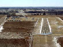 Final approach into Markham | |||||||||||
| IATA: none – ICAO: none – TC LID: CNU8 | |||||||||||
| Summary | |||||||||||
| Airport type | Private | ||||||||||
| Owner | Wings of Flight Inc. | ||||||||||
| Operator | Markham Airport Inc. | ||||||||||
| Serves | Markham and Stouffville | ||||||||||
| Location | Markham, Ontario | ||||||||||
| Opened | 1965 | ||||||||||
| Time zone | EST (UTC−05:00) | ||||||||||
| • Summer (DST) | EDT (UTC−04:00) | ||||||||||
| Elevation AMSL | 807 ft / 246 m | ||||||||||
| Coordinates | 43°56′09″N 079°15′44″W / 43.93583°N 79.26222°WCoordinates: 43°56′09″N 079°15′44″W / 43.93583°N 79.26222°W | ||||||||||
| Map | |||||||||||
 CNU8 Location in Ontario | |||||||||||
| Runways | |||||||||||
| |||||||||||
|
Source: Canada Flight Supplement[1] | |||||||||||
Markham Airport or Toronto/Markham Airport, (TC LID: CNU8), is a private aerodrome operating 2.6 nautical miles (4.8 km; 3.0 mi) north of Markham, Ontario, Canada near Toronto.
The airport was founded in 1965 by two former Polish air force pilots[2] and is now owned by Wings of Flights, Inc., a privately held company owned by the Thomson family[3] since 1986 and operated by Markham Airport Inc. The airport is not part of the Greater Toronto Airports Authority (GTAA). The airport consists of a single 2,013 ft (614 m) runway for small and private aircraft only (with night flying capabilities). The Royal Canadian Air Cadets Gliding Program uses the north side of the runway 09/27 for glider operations in the spring and fall months, and use a northern traffic pattern.[1]
Airport data
- Coordinates: N43 56 09 W79 15 44 UTC−5(4)
- Runway 09/27: 2,013 ft × 50 ft (614 m × 15 m) - asphalt
- Elevation: 807’ VTA A5000 F-21
- Unicom Frequency: 122.80
- Runway orientation: 09/27
- Lighting: 09-(TE ME), 27-(TE ME) PNR Opr
- ATF: UNICOM LTD HRS o/t TFC 122.8 5 NM (9.3 km; 5.8 mi) 3500 ASL excluding portion within CYKZ CZ capped at 2000 ASL
- Radio: 122.8 MHz for ATF radio communications
- Tower: none - ATC operates from Buttonville Municipal Airport
- Buildings: Aerodrome
Airport Address: 10953 Highway 48 Markham, ON L3P 3J7
There are plans for a 6,000 ft (1,829 m) runway, but it would require approval as the runway would require additional land.
Tenants
- Canadian Flyers International[4]
- Central Region Spring Familiarization Flying Program - Royal Canadian Air Cadets
- Greater Toronto Gliding Centre (Royal Canadian Air Cadets Schweizer SGS 2-33A)
Facilities
Located at the entrance of the airfield is a classrooms used by tenant flight school Canadian Flyer International. There is one small hangar at the airport with most aircraft parked on the grass on the south side of the runway. A number of storage sheds, portables and trailers are found at the airport.
The airport tarmac is also home to a few aircraft and other military equipment from the Canadian Air, Land and Sea Museum.
- CT-128 Expeditor transport
- CT-133 Silver Star
- CF-5 Freedom Fighter
- CF-104 Starfighter (Various Airforces)
- Canadair CL-13 Sabre
- Schweizer SGS 2-33A Royal Canadian Air Cadets
- Noorduyn Norseman - shell only
- Bedford TK 4x4 - appears to have disappeared
Ground transportation
- There are GO Transit flag stops of either side of Highway 48 at the entrance of the airport serving bus Route 71.
GO Transit Stouffville trains pass to the east of the airport.
Most users of Markham Airport drive or can take a taxi. Highway 48 and Elgin Mills Road are the closest major roads serving the airport. There is limited parking at the airport.
Support
The airport has an office staffed by 5 employees.
The airport has no ARFF services and relies on local fire services. Markham Fire and Emergency Services Stations 9-7 and 9-8 are the nearest within Markham, although Whitchurch-Stouffville Fire Department Station 5-1 is closer to the airport. Medical services are provided by York Region EMS Station 23 in Markham or Station 21 in Stouffville.
The only aviation fuel available at Markham Airport is 100LL for light aircraft.[1]
Future
The airport's future is tied to the development of the Pickering Airport and restrictions under the Aeronautics Act.[2]
See also
References
- 1 2 3 Canada Flight Supplement. Effective 0901Z 15 September 2016 to 0901Z 10 November 2016
- 1 2 Flights of fancy at Markham Airport: a former Cold War pilot’s big plans
- ↑ Billionaire owners mum on Markham Airport
- ↑ "Locations". Canadian Flyers International. Archived from the original on June 7, 2009. Retrieved 2009-05-18.
- "Airports". Transportation. Town of Whitchurch-Stouffville. 2005-12-21. Archived from the original on 2005-12-21. Retrieved 2009-05-18.
External links
- Page about this airport on COPA's Places to Fly airport directory
- Canadian Flyers - Markham Airport
| By name | |
|---|---|
| By location indicator | |
| By province/territory | |
| By region | |
| National Airports System | |
| Related | |
| |