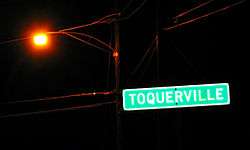
Toquerville, Utah
| Toquerville, Utah | |
|---|---|
| City | |
|
Welcome to Toquerville | |
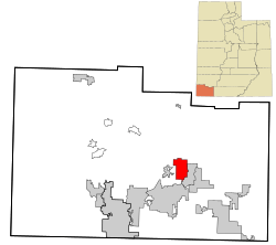 Location in Washington County and the state of Utah | |
| Coordinates: 37°15′14″N 113°17′9″W / 37.25389°N 113.28583°WCoordinates: 37°15′14″N 113°17′9″W / 37.25389°N 113.28583°W | |
| Country | United States |
| State | Utah |
| County | Washington |
| Settled | 1858 |
| Named for | Chief Toquer |
| Area | |
| • Total | 14.2 sq mi (36.7 km2) |
| • Land | 14.2 sq mi (36.7 km2) |
| • Water | 0.0 sq mi (0.0 km2) |
| Elevation | 3,389 ft (1,033 m) |
| Population (2012) | |
| • Total | 1,404 |
| • Density | 64.3/sq mi (24.8/km2) |
| Time zone | Mountain (MST) (UTC-7) |
| • Summer (DST) | MDT (UTC-6) |
| ZIP code | 84774 |
| Area code(s) | 435 |
| FIPS code | 49-76900[1] |
| GNIS feature ID | 1446655[2] |
Toquerville is a city in Washington County, Utah, United States. The population was 1,370 at the 2010 census.
Geography
According to the United States Census Bureau, the city has a total area of 14.2 square miles (36.7 km²), all of it land.
Demographics
| Historical population | |||
|---|---|---|---|
| Census | Pop. | %± | |
| 1860 | 79 | — | |
| 1870 | 264 | 234.2% | |
| 1880 | 371 | 40.5% | |
| 1890 | 260 | −29.9% | |
| 1900 | 144 | −44.6% | |
| 1910 | 186 | 29.2% | |
| 1920 | 331 | 78.0% | |
| 1930 | 288 | −13.0% | |
| 1940 | 263 | −8.7% | |
| 1950 | 219 | −16.7% | |
| 1960 | 197 | −10.0% | |
| 1970 | 185 | −6.1% | |
| 1980 | 277 | 49.7% | |
| 1990 | 488 | 76.2% | |
| 2000 | 910 | 86.5% | |
| 2010 | 1,370 | 50.5% | |
| Est. 2015 | 1,493 | [3] | 9.0% |
As of the census[1] of 2000, there were 910 people, 282 households, and 236 families residing in the town. The population density was 64.3 people per square mile (24.8/km²). There were 325 housing units at an average density of 23.0 per square mile (8.9/km²). On the 12th of July 2007, the City Council approved the development of 3000 households. The racial makeup of the town was 97.03% White, 0.11% African American, 0.88% Native American, 0.11% Asian, 0.11% Pacific Islander, 0.77% from other races, and 0.99% from two or more races. Hispanic or Latino of any race were 2.86% of the population.
There were 282 households out of which 36.9% had children under the age of 18 living with them, 72.0% were married couples living together, 9.6% had a female householder with no husband present, and 16.3% were non-families. 14.2% of all households were made up of individuals and 4.6% had someone living alone who was 65 years of age or older. The average household size was 3.23 and the average family size was 3.56.
In the town the population was spread out with 32.9% under the age of 18, 9.3% from 18 to 24, 19.6% from 25 to 44, 24.6% from 45 to 64, and 13.6% who were 65 years of age or older. The median age was 34 years. For every 100 females there were 101.8 males. For every 100 females age 18 and over, there were 97.1 males.
The median income for a household in the town was $34,038, and the median income for a family was $36,146. Males had a median income of $26,964 versus $20,938 for females. The per capita income for the town was $12,713. About 10.7% of families and 14.6% of the population were below the poverty line, including 17.1% of those under age 18 and 2.5% of those age 65 or over.
History
Toquerville was named after an early Paiute chief. The population has grown from only 19 families in the late 1800s. Toquerville's proximity to Zion National Park has created a healthy tourism economy where the community traditionally had depended on agriculture.
Although it was still a town at the 2000 census, Toquerville became a city at the end of 2000.[5]
References
- 1 2 "American FactFinder". United States Census Bureau. Retrieved 2008-01-31.
- ↑ "US Board on Geographic Names". United States Geological Survey. 2007-10-25. Retrieved 2008-01-31.
- ↑ "Annual Estimates of the Resident Population for Incorporated Places: April 1, 2010 to July 1, 2015". Retrieved July 2, 2016.
- ↑ "Census of Population and Housing". Census.gov. Retrieved June 4, 2015.
- ↑ Trauntvein, Myrna (December 9, 2000). "Mona is now a third-class city". Deseret News. p. A18. Retrieved June 17, 2009.
External links
![]() Media related to Toquerville, Utah at Wikimedia Commons
Media related to Toquerville, Utah at Wikimedia Commons
 |
Enterprise | New Harmony | Kanarraville | |
| Leeds | |
Zion National Park | ||
| ||||
| | ||||
| Hurricane | La Verkin |
Municipalities and communities of Washington County, Utah, United States | ||
|---|---|---|
| Cities | 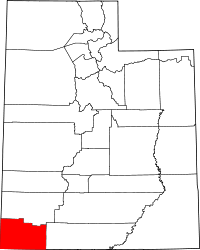 | |
| Towns | ||
| CDPs | ||
| Unincorporated communities | ||
| Ghost towns | ||