Tomahawk, West Virginia
| Tomahawk | |
|---|---|
| Unincorporated community | |
|
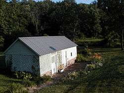
Tomahawk Springhouse | |
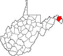
 Tomahawk  Tomahawk Location within the state of West Virginia | |
| Coordinates: 39°31′49″N 78°2′49″W / 39.53028°N 78.04694°WCoordinates: 39°31′49″N 78°2′49″W / 39.53028°N 78.04694°W | |
| Country | United States |
| State | West Virginia |
| County | Berkeley |
| Elevation | 469 ft (143 m) |
| Time zone | Eastern (EST) (UTC-5) |
| • Summer (DST) | EDT (UTC-4) |
| GNIS feature ID | 1555816[1] |
Tomahawk is an unincorporated community on Back Creek in Berkeley County, West Virginia.[1] The community is named for a nearby series of springs in the shape of a tomahawk.[2] The community includes the historic Tomahawk Presbyterian Church, established c. 1745, and its adjacent community cemetery, which has gravestones dating to the late 18th century.
Tomahawk Spring and the Park's Gap Bridge were listed on the National Register of Historic Places in 1994.[3]
References
- 1 2 "Tomahawk". Geographic Names Information System. United States Geological Survey.
- ↑ Kenny, Hamill (1945). West Virginia Place Names: Their Origin and Meaning, Including the Nomenclature of the Streams and Mountains. Piedmont, WV: The Place Name Press. p. 628.
- ↑ National Park Service (2009-03-13). "National Register Information System". National Register of Historic Places. National Park Service.
External links
This article is issued from Wikipedia - version of the 7/28/2016. The text is available under the Creative Commons Attribution/Share Alike but additional terms may apply for the media files.