Timrå
| Timrå | |
|---|---|
|
Timrå montage, Top:Panorama view of downtown Timrå, from Alnön area, 2nd left:A native house and museum in Merlo Slotto, 2nd right:A headquarters in Östrands pulp (Östrands massafabrik), 3rd left:Sydkraft Arena (E.ON Arena), 3rd right:Köpmansgatan Square, Bottom:Aerial view over Sörberge with Indalsälven left and Fairhaven in the upper right corner | |
 Timrå  Timrå | |
| Coordinates: 62°29′13″N 17°19′33″E / 62.48694°N 17.32583°ECoordinates: 62°29′13″N 17°19′33″E / 62.48694°N 17.32583°E | |
| Country | Sweden |
| Province | Medelpad |
| County | Västernorrland County |
| Municipality | Timrå Municipality |
| Area[1] | |
| • City | 12.03 km2 (4.64 sq mi) |
| • Metro | 787.98 km2 (304.24 sq mi) |
| Elevation | 19 m (62 ft) |
| Population (31 December 2010)[1] | |
| • City | 10,443 |
| • Density | 868/km2 (2,250/sq mi) |
| • Metro | 17,844 |
| Time zone | CET (UTC+1) |
| • Summer (DST) | CEST (UTC+2) |
| Postal code | 860 xx |
| Area code(s) | (+46) 60 |
| Website |
www |

Timrå is a locality and the seat of Timrå Municipality in Västernorrland County, Sweden with 10,443 inhabitants in 2010.[1]
It is located about 13 km north of Sundsvall (a town with a metropolitan area of some 100,000 inhabitants), and could arguably be considered a satellite to that town.
The two closest cities (Sundsvall and Härnösand) share one airport, Midlanda, that is geographically located in Timrå.
Indalsälven, one of Sweden's largest rivers with a length of 430 km, meets the Gulf of Botnia in Timrå.
In Sweden, Timrå is mainly known for its ice hockey club Timrå IK, which has played in the Swedish top division SHL.
In 1995, Swedish artist Bengt Lindström constructed the Y, a 30 meter high sculpture located in Timrå.
Climate
Timrå has historically had a subarctic climate, but it has in recent decades more resembled a cool-summer humid continental climate.
| Climate data for Sundsvall Airport near Timrå (2002-2015); extremes since 1943; precipitation 1961-1990 | |||||||||||||
|---|---|---|---|---|---|---|---|---|---|---|---|---|---|
| Month | Jan | Feb | Mar | Apr | May | Jun | Jul | Aug | Sep | Oct | Nov | Dec | Year |
| Record high °C (°F) | 11.0 (51.8) |
13.8 (56.8) |
15.2 (59.4) |
21.9 (71.4) |
27.4 (81.3) |
31.0 (87.8) |
33.0 (91.4) |
31.3 (88.3) |
27.2 (81) |
20.1 (68.2) |
14.0 (57.2) |
10.5 (50.9) |
33.0 (91.4) |
| Average high °C (°F) | −2.5 (27.5) |
−1.4 (29.5) |
3.2 (37.8) |
8.5 (47.3) |
13.9 (57) |
18.3 (64.9) |
21.5 (70.7) |
20.0 (68) |
15.4 (59.7) |
8.2 (46.8) |
2.5 (36.5) |
−0.8 (30.6) |
8.0 (46.4) |
| Daily mean °C (°F) | −6.6 (20.1) |
−5.8 (21.6) |
−1.5 (29.3) |
3.5 (38.3) |
8.6 (47.5) |
12.8 (55) |
16.6 (61.9) |
15.4 (59.7) |
10.7 (51.3) |
4.3 (39.7) |
−0.4 (31.3) |
−4.4 (24.1) |
4.4 (39.9) |
| Average low °C (°F) | −10.6 (12.9) |
−10.2 (13.6) |
−6.3 (20.7) |
−1.5 (29.3) |
3.3 (37.9) |
7.4 (45.3) |
11.8 (53.2) |
10.8 (51.4) |
6.0 (42.8) |
0.4 (32.7) |
−3.4 (25.9) |
−8.1 (17.4) |
0.0 (32) |
| Record low °C (°F) | −35.5 (−31.9) |
−34.8 (−30.6) |
−34.2 (−29.6) |
−20.0 (−4) |
−8.2 (17.2) |
−2.0 (28.4) |
1.9 (35.4) |
−0.6 (30.9) |
−7.7 (18.1) |
−15.2 (4.6) |
−22.1 (−7.8) |
−36.6 (−33.9) |
−36.6 (−33.9) |
| Average precipitation mm (inches) | 38.3 (1.508) |
28.1 (1.106) |
29.5 (1.161) |
31.9 (1.256) |
34.6 (1.362) |
40.7 (1.602) |
58.0 (2.283) |
64.1 (2.524) |
63.8 (2.512) |
51.8 (2.039) |
53.1 (2.091) |
46.1 (1.815) |
539.3 (21.232) |
| Source #1: SMHI precipitation average 1961-1990[2] | |||||||||||||
| Source #2: SMHI climate data 2002-2015[3] | |||||||||||||
Notable citizens
- Lennart "Lillstrimma" Svedberg (1944–1972), ice hockey player
- Magdalena Forsberg (1967), cross country skier, biathlon
- Henrik Flyman, guitarist, composer, producer
- Henrik Forsberg (1967), cross country skier
- Mats Näslund (1959), ice hockey player
Gallery
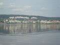 Timrå
Timrå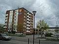 The municipal office
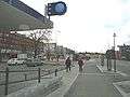 Town centre
 Östrand pulp mill
References
| Wikimedia Commons has media related to Timrå. |
- 1 2 3 "Tätorternas landareal, folkmängd och invånare per km2 2005 och 2010" (in Swedish). Statistics Sweden. 14 December 2011. Archived from the original on 10 January 2012. Retrieved 10 January 2012.
- ↑ "SMHI precipitation average 1961-1990" (in Swedish). Swedish Metereological and Hydrological Institute (Sundsvalls flygplats code 12 731).
- ↑ "SMHI climate data 2002-2015" (in Swedish). SMHI. April 11, 2016.
Municipalities and seats of Västernorrland County | ||
|---|---|---|
| Municipalities | ||
| Municipal seats | ||