Thunder Mountain (Amador County, California)
| Thunder Mountain | |
|---|---|
 Thunder Mountain | |
| Highest point | |
| Elevation | 9,414 ft (2,869 m) NAVD 88[1] |
| Prominence | 330 ft (101 m) [1] |
| Listing | California county high points 16th |
| Coordinates | 38°40′27″N 120°05′27″W / 38.6740752°N 120.090742°WCoordinates: 38°40′27″N 120°05′27″W / 38.6740752°N 120.090742°W [2] |
| Geography | |
| Location | Amador County, California, U.S. |
| Parent range | Sierra Nevada |
| Topo map | USGS Caples Lake |
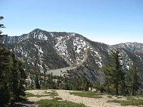
Thunder Mountain in the Sierra Nevada of California is located east of Silver Lake and west of Kirkwood Mountain Resort[3] in the Eldorado National Forest. The mountain has two peaks, the 9,414-foot (2,869 m) main peak[1] and a 9,412-foot (2,869 m) sub-peak west of the main peak.[4] The main summit is the highest point in Amador County.[1] Due to the high elevation, most precipitation that falls on Thunder Mountain consists of snow.[5]
The peak was named by United States Forest Service personnel because "thunderstorms appear to build up in that area."[6]
References
- 1 2 3 4 "Thunder Mountain, California". Peakbagger.com. Retrieved 2009-08-06.
- ↑ "Thunder Mountain". Geographic Names Information System. United States Geological Survey. Retrieved 2009-08-06.
- ↑ Caples Lake quadrangle, California (Map). 1:24000. 7.5 Minute Topographic. USGS. Retrieved 2009-12-09.
- ↑ "Thunder Mountain-West Peak, California". Peakbagger.com. Retrieved 2009-08-06.
- ↑ "Subsection M261Ek - Glaciated Batholith and Volcanic Flows". USDA, Forest Service. Archived from the original on 2007-08-13. Retrieved 2007-12-03.
- ↑ Browning, Peter (1986). Place Names of the Sierra Nevada. Berkeley: Wilderness Press. p. 216. ISBN 0899971199.
External links
- "Thunder Mountain (CA)". SummitPost.org.
This article is issued from Wikipedia - version of the 9/10/2016. The text is available under the Creative Commons Attribution/Share Alike but additional terms may apply for the media files.