Thorigny-sur-Oreuse
| Thorigny-sur-Oreuse | |
|---|---|
|
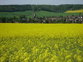
Thorigny-sur-Oreuse in spring colours | |
 Thorigny-sur-Oreuse | |
|
Location within Bourgogne-Franche-Comté region  Thorigny-sur-Oreuse | |
| Coordinates: 48°17′36″N 3°24′09″E / 48.2933°N 3.40250°ECoordinates: 48°17′36″N 3°24′09″E / 48.2933°N 3.40250°E | |
| Country | France |
| Region | Bourgogne-Franche-Comté |
| Department | Yonne |
| Arrondissement | Sens |
| Canton | Sergines |
| Area1 | 49.23 km2 (19.01 sq mi) |
| Population (2006)2 | 1,468 |
| • Density | 30/km2 (77/sq mi) |
| Time zone | CET (UTC+1) |
| • Summer (DST) | CEST (UTC+2) |
| INSEE/Postal code | 89414 / 89260 |
| Elevation | 83–206 m (272–676 ft) |
| Website | http://www.thorigny.net |
|
1 French Land Register data, which excludes lakes, ponds, glaciers > 1 km² (0.386 sq mi or 247 acres) and river estuaries. 2 Population without double counting: residents of multiple communes (e.g., students and military personnel) only counted once. | |
Thorigny-sur-Oreuse is a commune in the Yonne department in Bourgogne-Franche-Comté in north-central France.[1]
History
The history of the village from the pre-historic and Roman periods has been well documented in the book written in 1886 by the abbot Henri Bouvier Histoire de Thorigny-sur-Oreuse.
An effort by the heritage society "Les amis de Thorigny"[2] attempts to bring to light the historical importance of this naturally beautiful ancient village and to protect the important monuments such as the sloping medieval church with still visible military fortifications[2] and which was built on the source of the Oreuse river, the beautiful gardens of the Château du Thorigny which was dismantled during the revolution, the Château de Fleurigny and the Commanderie de Launay.[3]
See also
References
| Wikimedia Commons has media related to Thorigny-sur-Oreuse. |