Arrondissement of Sens
| Sens | |
|---|---|
| Arrondissement of France | |
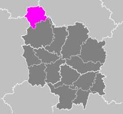 Location of Sens in Bourgogne | |
| Country | France |
| Region | Bourgogne-Franche-Comté |
| Department | Yonne |
| Communes | 106 |
| Prefecture | Sens |
| Area¹ | |
| • Total | 1,704 km2 (658 sq mi) |
| Population (2013) | |
| • Total | 113,091 |
| • Density | 66/km2 (170/sq mi) |
| ¹ French Land Register data, which exclude lakes, ponds, and glaciers larger than 1 km² as well as the estuaries of rivers. | |
The Arrondissement of Sens is an arrondissement of France in the Yonne department in the Bourgogne-Franche-Comté region. It has 106 communes.[1]
Composition
Cantons
The cantons of the arrondissement of Sens are:
- Brienon-sur-Armançon (partly)
- Charny (partly)
- Gâtinais en Bourgogne
- Joigny (partly)
- Pont-sur-Yonne
- Sens-1
- Sens-2
- Thorigny-sur-Oreuse
- Villeneuve-sur-Yonne
Communes
The communes of the arrondissement of Sens, and their INSEE codes, are:[1]
- Arces-Dilo (89014)
- Armeau (89018)
- Bagneaux (89027)
- La Belliole (89036)
- Bœurs-en-Othe (89048)
- Les Bordes (89051)
- Brannay (89054)
- Bussy-le-Repos (89060)
- La Celle-Saint-Cyr (89063)
- Cérilly (89065)
- Cerisiers (89066)
- Champigny (89074)
- La Chapelle-sur-Oreuse (89080)
- Chaumont (89093)
- Chaumot (89094)
- Chéroy (89100)
- Les Clérimois (89111)
- Collemiers (89113)
- Compigny (89115)
- Cornant (89116)
- Coulours (89120)
- Courgenay (89122)
- Courlon-sur-Yonne (89124)
- Courtoin (89126)
- Courtois-sur-Yonne (89127)
- Cudot (89133)
- Cuy (89136)
- Dixmont (89142)
- Dollot (89143)
- Domats (89144)
- Égriselles-le-Bocage (89151)
- Étigny (89160)
- Évry (89162)
- Flacy (89165)
- Foissy-sur-Vanne (89171)
- Fontaine-la-Gaillarde (89172)
- Fouchères (89180)
- Fournaudin (89181)
- Gisy-les-Nobles (89189)
- Gron (89195)
- Jouy (89209)
- Lailly (89214)
- Les Sièges (89395)
- Lixy (89229)
- Maillot (89236)
- Malay-le-Grand (89239)
- Malay-le-Petit (89240)
- Marsangy (89245)
- Michery (89255)
- Molinons (89261)
- Montacher-Villegardin (89264)
- Nailly (89274)
- Noé (89278)
- Pailly (89285)
- Paron (89287)
- Passy (89291)
- Perceneige (89469)
- Piffonds (89298)
- Plessis-Saint-Jean (89302)
- Pont-sur-Vanne (89308)
- Pont-sur-Yonne (89309)
- La Postolle (89310)
- Précy-sur-Vrin (89313)
- Rosoy (89326)
- Rousson (89327)
- Saint-Agnan (89332)
- Saint-Clément (89338)
- Saint-Denis-lès-Sens (89342)
- Saint-Julien-du-Sault (89348)
- Saint-Loup-d'Ordon (89350)
- Saint-Martin-d'Ordon (89353)
- Saint-Martin-du-Tertre (89354)
- Saint-Maurice-aux-Riches-Hommes (89359)
- Saint-Sérotin (89369)
- Saint-Valérien (89370)
- Saligny (89373)
- Savigny-sur-Clairis (89380)
- Sens (89387)
- Sépeaux-Saint-Romain (89388)
- Serbonnes (89390)
- Sergines (89391)
- Soucy (89399)
- Subligny (89404)
- Thorigny-sur-Oreuse (89414)
- Les Vallées-de-la-Vanne (89411)
- Vallery (89428)
- Vaudeurs (89432)
- Vaumort (89434)
- Verlin (89440)
- Vernoy (89442)
- Véron (89443)
- Villeblevin (89449)
- Villebougis (89450)
- Villechétive (89451)
- Villemanoche (89456)
- Villenavotte (89458)
- Villeneuve-l'Archevêque (89461)
- Villeneuve-la-Dondagre (89459)
- Villeneuve-la-Guyard (89460)
- Villeneuve-sur-Yonne (89464)
- Villeperrot (89465)
- Villeroy (89466)
- Villethierry (89467)
- Villiers-Louis (89471)
- Vinneuf (89480)
- Voisines (89483)
History
The arrondissement of Sens was created in 1800. In 1926 it was expanded with part of the former arrondissement of Joigny (the former cantons of Cerisiers, Saint-Julien-du-Sault and Villeneuve-sur-Yonne). In the 1970s the cantons of Sens-Nord-Est, Sens-Ouest and Sens-Sud-Est were created from the former cantons of Sens-Nord and Sens-Sud.
Before the French canton reorganisation which came into effect in March 2015, the cantons of the arrondissement of Sens were:
- Cerisiers
- Chéroy
- Pont-sur-Yonne
- Saint-Julien-du-Sault
- Sens-Nord-Est
- Sens-Ouest
- Sens-Sud-Est
- Sergines
- Villeneuve-l'Archevêque
- Villeneuve-sur-Yonne
References
External links
Coordinates: 48°14′51″N 3°17′16″E / 48.24750°N 3.28778°E