Thestieis
| Thestieis Θεστιείς | |
|---|---|
 | |
 Thestieis | |
|
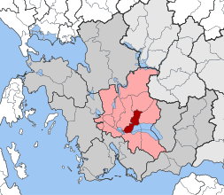
Location within the regional unit  | |
| Coordinates: 38°36′N 21°30′E / 38.600°N 21.500°ECoordinates: 38°36′N 21°30′E / 38.600°N 21.500°E | |
| Country | Greece |
| Administrative region | West Greece |
| Regional unit | Aetolia-Acarnania |
| Municipality | Agrinio |
| • Municipal unit | 75.1 km2 (29.0 sq mi) |
| Population (2011)[1] | |
| • Municipal unit | 6,566 |
| • Municipal unit density | 87/km2 (230/sq mi) |
| Time zone | EET (UTC+2) |
| • Summer (DST) | EEST (UTC+3) |
| Postal code | 300 05 |
| Area code(s) | 26410 |
Thestieis (Greek: Θεστιείς) is a former municipality in Aetolia-Acarnania, West Greece, Greece. Since the 2011 local government reform it is part of the municipality Agrinio, of which it is a municipal unit.[2] The municipal unit has an area of 75.058 km2.[3] The seat of the Thestieis municipal unit is Kainourgio. It is situated at the northwestern shore of Lake Trichonida.
References
- ↑ "Απογραφή Πληθυσμού - Κατοικιών 2011. ΜΟΝΙΜΟΣ Πληθυσμός" (in Greek). Hellenic Statistical Authority.
- ↑ Kallikratis law Greece Ministry of Interior (Greek)
- ↑ "Population & housing census 2001 (incl. area and average elevation)" (PDF) (in Greek). National Statistical Service of Greece.
External links
- Municipality of Thestieis (Greek)
This article is issued from Wikipedia - version of the 11/15/2016. The text is available under the Creative Commons Attribution/Share Alike but additional terms may apply for the media files.