Thayetchaung Township
| Thayetchaung Township | |
|---|---|
| Township | |
 Thayetchaung Township Location in Burma | |
| Coordinates: 13°41′N 98°26′E / 13.683°N 98.433°ECoordinates: 13°41′N 98°26′E / 13.683°N 98.433°E | |
| Country |
|
| Region | Taninthayi Region |
| District | Dawei District |
| Capital | Thayetchaung |
| Time zone | MST (UTC+6.30) |
Thayetchaung Township (Burmese: သရက်ချောင်းမြို့နယ်) is a township of Dawei District in the Taninthayi Division of Burma (Myanmar). The principal town is Thayetchaung.
Subdivisions
Thayetchaung Township is composed of 39 rural tracts, and one urban tract, Thayetchaung. The rural tracts are:[1]
|
|
|
|
Notes
- ↑ "Thayetchaung Township, Tanintharyi, Myanmar", Myanmar Information Management Unit (MIMU), 12 August 2010
External links
- "Thayetchaung Google Satellite Map" Maplandia World Gazetteer
Capital: | |
|
Capital: Dawei | ||
| Dawei District |  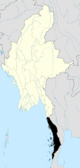 | |
| Kawthaung District |
| |
| Myeik District | ||
| Main cities and towns | ||
This article is issued from Wikipedia - version of the 10/26/2013. The text is available under the Creative Commons Attribution/Share Alike but additional terms may apply for the media files.