Texas State Highway NASA Road 1
| ||||
|---|---|---|---|---|
 | ||||
| Route information | ||||
| Maintained by TxDOT | ||||
| Length: | 7.474 mi[1] (12.028 km) | |||
| Existed: | 1965 – present | |||
| Major junctions | ||||
| West end: |
| |||
| East end: |
| |||
| Highway system | ||||
| ||||

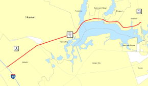
State Highway NASA Road 1 (also NASA Parkway and NASA Road 1[2]) is an east–west state highway that runs from Interstate 45 in Webster to State Highway 146 in Seabrook. The route is a 6-lane to 8-lane divided highway for most of its length. A Portion of the route is a 4-lane controlled access highway that bypasses the central businesses of Webster. The highway is the main route to NASA's Lyndon B. Johnson Space Center. It is one of only two Texas highways with an official designation beginning with a letter; the other is State Highway OSR.
History
The highway was originally designated as Farm to Market Road 528 (FM 528) in 1945,[3] but upon the opening of Johnson Space Center, the portion of FM 528 from I-45 to SH 146 was redesignated as NASA Road 1.[1]
Route description
NASA Road 1 begins at I-45 in Webster and heads towards the northeast through Webster intersecting SH 3 and FM 270. The highway passes along the southern boundary of the Johnson Space Center and provides access to the Space Center. The highway follows the north shore of Clear Lake and ends at SH 146 in Seabrook.[4][5]
NASA 1 Bypass Freeway is a freeway that passes to the south of Webster. It is 2.7 miles (4.3 km) long and has 4 mainlanes. The contract for construction was awarded in 2004 and it opened in December 2008. The freeway consists of two direct access ramps which are convenient for travelers coming to and from Houston. One of these ramps provides southbound travelers from I-45 with direct access to the bypass (flying over I-45 in a three-tier stack configuration), and the other provides travelers with the opportunity to merge onto I-45 northbound without encountering any traffic signals. Motorists coming from Galveston (I-45 northbound) have to encounter a traffic signal at Kobayashi Road before experiencing the uninterrupted flow of the freeway. The freeway bypasses much of the congestion in inner-city Webster, giving easy access to Johnson Space Center.
Major junctions
The entire route is in Harris County.
| Location | mi[4] | km | Destinations | Notes | |
|---|---|---|---|---|---|
| Webster | 0.000 | 0.000 | I-45 exit 25; western terminus. | ||
| 0.9 | 1.4 | ||||
| 1.5 | 2.4 | NASA 1 Bypass | |||
| 1.8 | 2.9 | ||||
| Seabrook | 7.414 | 11.932 | Eastern terminus | ||
| 1.000 mi = 1.609 km; 1.000 km = 0.621 mi | |||||
References
- 1 2 Texas Department of Transportation. "Highway Designation File - State Highway NASA Road No. 1". Retrieved 2008-03-15.
- ↑ (HB1049 78(R)) Texas Legislature Online - 78(R) History for HB 1049
- ↑ Texas Department of Transportation. "Designation File: Farm to Market Road No. 528". Retrieved 2008-02-20.
- 1 2 Google (2012-09-13). "Texas State Highway NASA Road 1" (Map). Google Maps. Google. Retrieved 2012-09-13.
- ↑ Google (2008-02-20). "overview map of NASA Road 1 via NASA Road 1 Bypass" (Map). Google Maps. Google. Retrieved 2008-02-20.
External links
- Houston Freeways, Ch.4: The Spokes Erik Slotboom, September 13, 2005, updated June, 2005.
- NASA 1 bypass Erik Slotboom, May 7, 2005.