Texas State Highway 61
| ||||
|---|---|---|---|---|
 | ||||
| Route information | ||||
| Maintained by TxDOT | ||||
| Length: | 21.426 mi[1] (34.482 km) | |||
| Existed: | by 1926 – present | |||
| Major junctions | ||||
| South end: | Washington Ave. in Anahuac | |||
|
| ||||
| North end: |
| |||
| Location | ||||
| Counties: | Chambers, Liberty | |||
| Highway system | ||||
| ||||

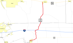
Texas State Highway 61 (SH 61) is a 21.426-mile (34.482 km) state highway in southeast Texas. It connects Anahuac in Chambers County to Devers in Liberty County.[1]
Route description
The southern terminus of SH 61 is in Anahuac, along Washington Avenue; state maintenance begins just south of Stowell Street.[2] The route travels north into Anahuac before turning to the east. It passes the Chambers County Airport before an intersection with SH 65; SH 61 turns to the north, while SH 65 continues east. SH 61 crosses IH 10 near the community of Turtle Bayou, northeast of Lake Anahuac.[3] The route travels north into Liberty County before reaching its northern terminus in Devers at US 90.[1]
History
SH 61 was designated by 1926 along the southern portion of the route previously numbered SH 35A. Its official designation has remained unchanged since the 1939 redescription of the Texas highway system.[1]
Major intersections
| County | Location | mi[4] | km | Destinations | Notes |
|---|---|---|---|---|---|
| Chambers | Anahuac | 0.0 | 0.0 | Washington Avenue | Southern terminus; state maintenance ends |
| 1.1 | 1.8 | ||||
| Four Corners | 3.1 | 5.0 | |||
| | 5.2 | 8.4 | |||
| | 6.9 | 11.1 | I-10 exit 813. | ||
| Hankamer | 9.1 | 14.6 | |||
| Liberty | | 15.5 | 24.9 | ||
| Devers | 21.4 | 34.4 | Northern terminus | ||
| 1.000 mi = 1.609 km; 1.000 km = 0.621 mi | |||||
References
- 1 2 3 4 Transportation Planning and Programming Division (n.d.). "State Highway No. 61". Highway Designation Files. Texas Department of Transportation. Retrieved 2011-01-07.
- ↑ Transportation Planning and Programming Division (2012). Texas County Map Book (PDF) (Map) (2012 ed.). 1:120,000. Texas Department of Transportation. p. 600. OCLC 867856197. Retrieved 2011-01-07.
- ↑ Transportation Planning and Programming Division (2012). Texas County Map Book (PDF) (Map) (2012 ed.). 1:120,000. Texas Department of Transportation. p. 599. OCLC 867856197. Retrieved 2011-01-07.
- ↑ Google (2011-01-07). "Overview map of Texas State Highway 61 Distances Between Interchanges" (Map). Google Maps. Google. Retrieved 2011-01-07.