Texas Recreational Road 2
| ||||
|---|---|---|---|---|
| Route information | ||||
| Maintained by TxDOT | ||||
| Length: | 7.198 mi[1] (11.584 km) | |||
| Existed: | June 1, 1970[1] – present | |||
| Major junctions | ||||
| West end: | Boat-launch ramp near Rough Canyon Colonia | |||
| East end: |
| |||
| Location | ||||
| Counties: | Val Verde | |||
| Highway system | ||||
| ||||

Recreational Road 2 (RE 2) is a Recreational Road located in Val Verde County in the southwestern portion of the U.S. state of Texas. The highway is approximately 7.2 miles (11.6 km) in length, and connects the Rough Canyon Colonia portion of the Amistad National Recreation Area to U.S. Highway 277 (US 227) and US 377. The roadway travels through mainly rural areas. A road first appeared in the location of RE 2 around 1940. RE 2 was officially designated in June 1970, and was just the second Recreational Road formed at the time.
Route description
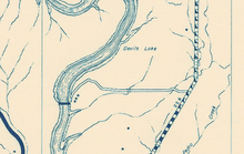
RE 2 begins at the Rough Canyon boat-launch ramp on the Amistad Reservoir in the Rough Canyon Colonia region of the Amistad National Recreation Area. From this terminus, the highway proceeds as a two-lane, paved road, which travels through a small parking lot and turns northeastward. The road continues northeast as it passes the Rough Canyon Marina and the Rough Canyon Colonia camping area on the eastern edge of the park, as well as several houses and independent camp sites. The highway intersects Cam Real Road, which leads to the Devils Shores community and the surrounding area. The route bends eastward, passing the Rough Canyon Inn and a small parking lot and intersecting a small road before it continues into rural areas again. Proceeding along a small ridge, the highway bends northeastward and travels over a small unnamed wash before reaching its eastern terminus with US 277/US 377.[2][3]

The Texas Department of Transportation (TxDOT) publishes yearly reports of the highway's annual average daily traffic (AADT), with counts usually taken near intersections. In 2011, the route's AADT was 310 vehicles, taken from a point to the west of the US 277/US 377 intersection.[4] This count was exactly the same as the one taken in 2010,[5] which in turn was a decrease from the count taken in 2009, when RE 2's AADT count was 440 vehicles.[6] No portion of the highway is listed on the National Highway System,[7] a network of roads important to the country's economy, defense, and mobility.[8]
History
A road first appeared in the location of RE 2 around 1940. This road was an unimproved dirt route with a primitive bridge over a small creek near the middle of it. The road led to a small community made up of three residential buildings.[9] By 1951, the highway's bridge had been converted to a small concrete dip which allowed the creek to flow through it.[10] By 1956, this road had been improved to a graded, drained gravel surface.[11] By 1961, it had been improved to a metal surface, and had been straightened along the eastern portion. Two additional concrete dips had been constructed, over two small creeks connecting to Devils River. In addition, the community which the road served had expanded to five residential buildings and a gate was built at the western end of the highway.[12]
The first serious interest in the road came in mid-1969, when the National Park Service approved a plan to develop the facilities with Amistad. The Rough Canyon and Diablo East portions of the park were given particular focus, since they were the only two that were in existence at the time. Large boat ramps were constructed at both areas, in an attempt to increase tourism.[13]
In early August 1971, several consecutive days of heavy rainfall led to flooding throughout the area. Several highways in the area were damaged, including RE 2. Portions of the highway were completely washed out, which took about two weeks to repair.[14][15]
On April 1, 1970, RE 2 was officially designated by TxDOT.[1] RE 2, along with Recreational Road 255, became the first routes designated as "recreational roads" by the Texas State Highway Department.[16][17] However, both highways still had to be approved by the Highway Department's Administration Circle; RE 255 was approved on April 15, 1970, making it the first official highway.[18] RE 2 was approved by the Administration Circle on June 1, 1970, making it the second route officially designated as a recreational road.[1] Since RE 2's designation, each recreational road has been numbered sequentially.[17] Between 1970 and 1972, the highway was paved, and the concrete dips replaced with drainage pipes. One of the route's bends was straightened, shortening it from 7.4 miles (11.9 km) to about 7.2 miles (11.6 km) in length.[19] The highway has not undergone any major rerouting or redesignation since.[1]
Major intersections
The entire highway is in Val Verde County.
| Location | mi[20] | km | Destinations | Notes | |
|---|---|---|---|---|---|
| Rough Canyon Colonia | 0.000 | 0.000 | Western end of state maintenance | ||
| 1.088 | 1.751 | Southern terminus of CR 219 | |||
| 1.479 | 2.380 | Southern terminus of CR 39 | |||
| | 7.198 | 11.584 | Eastern terminus | ||
| 1.000 mi = 1.609 km; 1.000 km = 0.621 mi | |||||
See also
 Texas portal
 U.S. Roads portal
References
- 1 2 3 4 5 Transportation Planning and Programming Division (n.d.). "Recreational Road No. 2". Highway Designation Files. Texas Department of Transportation. Retrieved April 2, 2013.
- ↑ Google (April 2, 2013). "Overview Map of Texas Recreational Road 2" (Map). Google Maps. Google. Retrieved April 2, 2013.
- ↑ Transportation Planning and Programming Division (2014). Texas County Map Book (PDF) (Map) (2014 ed.). 1:120,000. Texas Department of Transportation. p. 193. Retrieved March 31, 2015.
- ↑ Laredo District Base Sheets (PDF) (Map) (2011 ed.). Cartography by Transportation Planning and Programming Division. Texas Department of Transportation. 2011. Map 3. Retrieved April 2, 2013.
- ↑ Laredo District Base Sheets (PDF) (Map) (2010 ed.). Cartography by Transportation Planning and Programming Division. Texas Department of Transportation. 2010. Map 3. Retrieved April 2, 2013.
- ↑ Laredo District Base Sheets (PDF) (Map) (2009 ed.). Cartography by Transportation Planning and Programming Division. Texas Department of Transportation. 2009. Map 3. Retrieved April 2, 2013.
- ↑ National Highway System: West Texas (PDF) (Map). Cartography by FHWA. Federal Highway Administration. March 2005. Retrieved April 2, 2013.
- ↑ Slater, Rodney E. (Spring 1996). "The National Highway System: A Commitment to America's Future". Public Roads. Washington, DC: Federal Highway Administration. 59 (4). ISSN 0033-3735. Retrieved April 2, 2013.
- ↑ General Highway Map Val Verde County Texas (Map). 1 in=2 mi. Cartography by State-Wide Highway Planning Survey. Texas State Highway Department. February 1, 1940 [from 1936]. OCLC 45871736. Retrieved April 2, 2013.
- ↑ General Highway Map Val Verde County Texas (Map). 1 in=2 mi. Cartography by State-Wide Highway Planning Survey. Texas State Highway Department. January 1, 1951 [from 1947]. OCLC 45871736.
- ↑ Highway Map of Texas (Map) (1956 ed.). 1 in=26 mi. Cartography by H.M. Gousha Company. Shell Oil Company. 1956. § K7. OCLC 176222198.
- ↑ General Highway Map Val Verde County Texas (Map). 1 in=4 mi. Cartography by Planning Survey Division. Texas State Highway Department. January 1, 1961 [from 1958]. OCLC 45871736. Retrieved April 2, 2013.
- ↑ Staff writer (September 7, 1969). "Additional Park Sites Are Planned". Del Rio News-Herald. Del Rio, TX. p. 80. OCLC 427389783. Retrieved April 1, 2015 – via Newspapers.com.

- ↑ Healer, Leo (August 4, 1971). "Outdoors in the Southwest...". Lubbock Avalanche-Journal. Lubbock, TX. p. 44. OCLC 13990546. Retrieved April 2, 2015 – via Newspapers.com.
- ↑ Staff writer (August 18, 1971). "Only Two Val Verde Highways Still Closed". Del Rio News-Herald. Del Rio, TX. p. 4. OCLC 427389783. Retrieved April 2, 2015 – via Newspapers.com.
- ↑ Transportation Planning and Programming Division. "Recreational Road Facts". Texas Department of Transportation. Retrieved April 2, 2013.
- 1 2 Transportation Planning and Programming Division. "Highway Designation Files: Search for 'RE–Recreational Road'". Texas Department of Transportation. Retrieved April 2, 2013.
- ↑ Transportation Planning and Programming Division (n.d.). "Recreational Road No. 255". Highway Designation Files. Texas Department of Transportation. Retrieved April 2, 2013.
- ↑ Rough Canyon Quadrangle (Map). 1:24000. 7.5 Minute Series (Topographic). Cartography by USGS. United States Geological Survey. 1972.
- ↑ Statewide Planning Map (Map). Cartography by Transportation Planning and Programming Division. Texas Department of Transportation. 2013. Retrieved April 2, 2013.