Tepuka Vili Vili
Tepuka Vili Vili or Tepuka Savilivili is an islet of Funafuti, Tuvalu.[1]
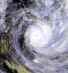
Cyclone Meli
Tepuka Vili Vili is part of the Funafuti Conservation Area, established in 1996 with the aim of preserving the natural fauna and flora of the area.[2]
Tepuka Vili Vili was devastated by Cyclone Keli in 1997, with all its vegetation and most of its sand swept away during the cyclone.[2]
Tepuka Vili Vili is an example of dynamic action of a coral atoll changing with the effect of cyclones and wave action:
| “ | a net loss in area of 22 percent since 1896 is only part of the story. The island has undergone an almost constant reworking of its sedimentary material during the past century. It's grown longer (by 550 feet, or 170 meters) and narrower (by 390 feet, or 120 meters), and its position has rotated clockwise on the reef.[3] | ” |
Te Ava Kum Kum is the passage through the Funafuti atoll in the middle of the western rim, south of Te Ava Tepuka Vili, between the islets of Tepuka Vili Vili to the north and Fualopa immediately south.[4]
References
- ↑ Map of Funafuti. Tuvaluislands.com.
- 1 2 "Kogatapu Funafuti Conservation Area". Tuvaluislands.com. Retrieved 28 Oct 2011.
- ↑ Warne, Kennedy (13 February 2015). "Will Pacific Island Nations Disappear as Seas Rise? Maybe Not - Reef islands can grow and change shape as sediments shift, studies show". National Geographic. Retrieved 14 February 2015.
- ↑ Admiralty Nautical Chart 2983 Tuvalu - Funafuti atoll. United Kingdom Hydrographic Office (UKHO).
| Islands |  | |
|---|---|---|
| Atolls | ||
| Islets of Funafuti | ||
| Islets of Nanumea | ||
| Islets of Nui | ||
| Islets of Nukufetau | ||
| Islets of Vaitupu | ||
Coordinates: 8°28′S 179°05′E / 8.467°S 179.083°E
This article is issued from Wikipedia - version of the 6/18/2016. The text is available under the Creative Commons Attribution/Share Alike but additional terms may apply for the media files.