Nui (atoll)
| Nui | |
|---|---|
| Atoll | |
 Aerial view of Nui | |
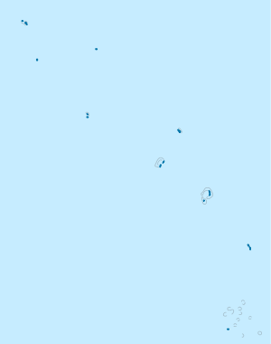 Nui Location in Tuvalu | |
| Coordinates: 07°13′29″S 177°09′37″E / 7.22472°S 177.16028°ECoordinates: 07°13′29″S 177°09′37″E / 7.22472°S 177.16028°E | |
| Country | Tuvalu |
| Area | |
| • Total | 3.37 km2 (1.30 sq mi) |
| Population (2012) | |
| • Total | 542 |
| • Density | 160/km2 (420/sq mi) |
| Demonym(s) | Nuian |
| ISO 3166 code | TV-NUI |
Nui is an atoll and one of nine districts of the Pacific Ocean state of Tuvalu.[1][2] It has a land area of 3.37 km² and a population of 542 (2012 census).[3]
Geography
Nui consists of at least 21 islets. These are:
- Fenua Tapu
- Motupuakaka
- Pakantou
- Piliaieve
- Pongalei
- Talalolae
- Telikiai, also known as Meang
- Tokinivae
- Unimai
- and at least 12 other islands
The biggest, most southern and most eastern island is Fenua Tapu (area 1.38 km²), which is followed by Telikiai (which is the most western islet), Tokinivae, Pongalei, Talalolae, Pakantou, Unimai, Piliaieve and Motupuakaka. Most people live on the western end of Fenua Tapu. In the 2012 census, 321 people live in Alamoni - Maiaki and 221 people live in Manutalake - Meang (Tanrake).[3] The junior school is Vaipuna Primary School.
Languages
The people of Nui speak the Gilbertese language, the language of Kiribati, and Tuvaluan, the official language of Tuvalu.[4] The ancestors of Nui came from both Samoa and the Gilbert Islands in what is now Kiribati. Traditionally Nuian culture is organised in three family circles - Tekaubaonga, Tekaunimala and Tekaunibiti families.[5]
Early history
The island was first sighted by Europeans on 16 January 1568 by Spanish navigator Álvaro de Mendaña, who named it Isla de Jesús (Spanish for "Island of Jesus") because it was discovered on the day following the feast of the Holy Name. There are no less than six accounts of this event, that of Mendaña himself being as follows:
"A little after nine o'clock in the morning, a lad called Trejo, being aloft, first sighted land upon the starboard side to the southwest...When we drew near, we found it so small that it was no more than six leagues in circumference. This island was very full of trees like palms; towards the north it had a reef, which entered the sea a quarter of a league, and towards the south was another smaller reef. On the west side it had a strand lying lengthways, with reefs in different parts. This is on the west side, for we could not go round the east side because of the weather. Taking this island from the sea outwards, it has the shape of two galleys, with a copse in the middle which appears like a fleet of ships"
Mendaña found the island inhabited and five canoes came nearly within bow shot of his ship, when their occupants raised their paddles and turned back with shouts. Mendaña thereupon ordered signals to be made to them with a white cloth to try to get them to return, instead of which they landed and in turn stuck up signals along the shore. At night one of the ships showed a light, it was copied by a fire, and when it was put out the fire extinguished also. Hernán Gallego, Mendaña's pilot, says the natives were "naked and mulattoes" and Pedro Sarmiento de Gamboa, cosmographer in the expedition reported that the island "had a large fishery". As it was late Mendaña decided to defer landing until the morning and kept the ships tacking all night. With the dawn, however, a strong westerly storm blew up, and although they tried all day to regain the island they were at length compelled to give up.[6][7][8][9]
A Dutch expedition (the frigate Maria Reigersberg[10]) found Nui on the morning of June 14, 1825 and named the main island (Fenua Tapu) as Nederlandsch Eiland (Dutch Island).[11]
_p405_Platte_Grond_van_het_Nederlandsch-Eiland.jpg) Dutch map of the island, made in June 1825
Dutch map of the island, made in June 1825_p297_Het_Nederlandsch_Eiland.jpg) View of the main island
View of the main island_p293_Het_Nederlandsch_Eilanden.jpg) View of the atoll
View of the atoll
The population of Nui from 1860–1900 is estimated to be between 250[12] and 300 people.[13] Martin Kleis was the resident trader on Nui in the late 19th Century who sold copra to Henderson and Macfarlane.[14][15]
Thomas Andrew (photographer) visited Nui in about 1885-86.[16][17]
Nui Post Office opened around 1919.[18]
Celebrations are held on Nui on the 16 February - Bogin te Ieka (Day of the Flood) - to commemorate the Tsunami that struck the island on that day in 1882.[5][19]
Cyclone Pam, March 2015
Nui was affected by storm surges caused by Cyclone Pam in early March 2015, which caused damage to houses, crops and infrastructure.[20] On 22 March, 71 families (40 percent of the population) of Nui remained displaced and were living in 3 evacuation centres or with other families.[21] The Situation Report published on 30 March reported that Nui suffered the most damage of the three central islands (Nui, Nukufetau and Vaitupu); with Nui suffering the loss of 90% of the crops.[22] Health assessment teams visited Nui and the other islands affected by Cyclone Pam.[23]
General election, 2015
The Tuvaluan general election, 2015 was held on 31 March.[24][25]
| Party | Candidate | Votes | % | |
|---|---|---|---|---|
| Non-partisan | Pelenike Isaia | 150 | 16.5 | |
| Non-partisan | Leneuoti Matusi | 227 | 25 | |
| Non-partisan | Taom Tanukale | 53 | 5.5 | |
| Non-partisan | Mackenzie Kiritome |
249 | 27 | |
| Non-partisan | Puakena Boreham |
237 | 26 | |
Notable local people
Sir Iakoba Italeli (GCMC) has been the Governor-General of Tuvalu since 16 April 2010 and was a former Minister of Education, Sports and Health, representing Nui in the Parliament.
Alesana Kleis Seluka (MBE, CBE) is medical doctor by profession and Chairman of the Public Service Commission of Tuvalu.[26] He has represented Nui in the parliament. He served as the Minister of Finance and Economic Planning from 1996 until 1999, and Minister of Health from 2001 to 2006.
Isaia Taeia Italeli was the Minister for Natural Resources at the time of his death in 2011.[27]
Pelenike Isaia became the second woman ever to have sat in the Parliament of Tuvalu, she became an MP in the by-election following the death of her husband - Isaia Taeia Italeli - and represented Nui until the Tuvaluan general election, 2015.[28]
References
- ↑ Map of Nui. Tuvaluislands.com.
- ↑ British Admiralty Nautical Chart 766 Ellice Islands (1893 ed.). United Kingdom Hydrographic Office (UKHO). 21 March 1872.
- 1 2 "Population of communities in Tuvalu". Thomas Brinkhoff. 11 April 2012. Retrieved 20 March 2016.
- ↑ "Tuvaluan (Te 'gana Tūvalu)". Omniglot. Retrieved 6 November 2012.
- 1 2 Sotaga Pape, Hugh Laracy (ed.) (1983). "Chapter 10 – Nui". Tuvalu: A History. Institute of Pacific Studies, University of the South Pacific and Government of Tuvalu. pp. 74–75.
- ↑ Maude, H.E. Spanish discoveries in the Central Pacific. A study in identification Journal of the Polynesian Society, Wellington, LXVIII, (1959), p.299,303.
- ↑ Maude, Islands and Men: Studies in Pacific History, Melbourne: Oxford University Press (1986)
- ↑ Keith S. Chambers & Doug Munro, The Mystery of Gran Cocal: European Discovery and Mis-Discovery in Tuvalu, 89(2) (1980) p.170 The Journal of the Polynesian Society, 167-198
- ↑ Laumua Kofe, Palagi and Pastors, Tuvalu: A History, Ch. 15, (U.S.P./Tuvalu)
- ↑ "Dutch warships available but not in active service in August 1834". 3 December 2011. Retrieved 22 March 2016.
- ↑ Pieter Troost: Aanteekeningen gehouden op eene reis om de wereld: met het fregat de Maria Reigersberg en de ... (1829) Digitalisat
- ↑ W.F. Newton, The Early Population of the Ellice Islands, 76(2) (1967) The Journal of the Polynesian Society, 197-204.
- ↑ Richard Bedford, Barrie Macdonald & Doug Monro, Population Estimates for Kiribati and Tuvalu (1980) 89(1) J. of the Polynesian Society 199
- ↑ Sotaga Pape, Hugh Laracy (ed.) (1983). "Chapter 10 – Nui". Tuvalu: A History. Institute of Pacific Studies, University of the South Pacific and Government of Tuvalu. p. 76.
- ↑ Mahaffy, Arthur (1910). "(CO 225/86/26804)". Report by Mr. Arthur Mahaffy on a visit to the Gilbert and Ellice Islands. Great Britain, Colonial Office, High Commission for Western Pacific Islands (London: His Majesty's Stationery Office).
- ↑ Andrew, Thomas (1886). "Mission House Nui. From the album: Views in the Pacific Islands". Collection of Museum of New Zealand (Te Papa). Retrieved 10 April 2014.
- ↑ Andrew, Thomas (1886). "Bread fruit tree Nui. From the album: Views in the Pacific Islands". Collection of Museum of New Zealand (Te Papa). Retrieved 10 April 2014.
- ↑ Premier Postal History. "Post Office List". Premier Postal Auctions. Retrieved 5 July 2013.
- ↑ "Nowhere to run. Tuvaluans consider their future after Tropical Cyclone Pam". Report from International Federation of Red Cross And Red Crescent Societies. 17 April 2015. Retrieved 17 April 2015.
- ↑ "Forgotten paradise under water". United Nations Development Programme. 1 May 2015. Retrieved 8 June 2015.
- ↑ "Tuvalu: Tropical Cyclone Pam Situation Report No. 1 (as of 22 March 2015)". Relief Web. 22 March 2015. Retrieved 25 March 2015.
- ↑ "Tuvalu: Tropical Cyclone Pam Situation Report No. 2 (as of 30 March 2015)". Relief Web. 30 March 2015. Retrieved 30 March 2015.
- ↑ "Tuvalu situation update: Securing health from disastrous impacts of cyclone Pam in Tuvalu". Relief Web/World health Organisation – Western Pacific Region. 3 April 2015. Retrieved 8 June 2015.
- ↑ "Election looks set to return Sopoaga as Tuvalu's PM". Radio New Zealand. 2 April 2015. Retrieved 2 April 2015.
- ↑ "Tuvalu National Election 2015 Results (Nui)". Fenui News. 1 April 2015. Retrieved 1 April 2015.
- ↑ Semi, Diana (6 April 2015). "Nuians were speechless when heard the news of the devastation impacted the island" (PDF). Fenui News. Retrieved 22 April 2014.
- ↑ "State Funeral for the Minister of Natural Resources, Hon Isaia Taeia Italeli" (PDF). Tuvalu Philatelic Bureau Newsletter (TPB: 01/2011). 25 July 2011. Retrieved 20 November 2012.
- ↑ "Palamene o Tuvalu (Parliament of Tuvalu)". Inter-Parliamentary Union. 2010. Retrieved 7 March 2013.
External links
- Map of Nui
- "A Brief History of Tuvalu" containing discussion of history of Nui
| Islands |  | |
|---|---|---|
| Atolls | ||
| Islets of Funafuti | ||
| Islets of Nanumea | ||
| Islets of Nui | ||
| Islets of Nukufetau | ||
| Islets of Vaitupu | ||