Temple, Georgia
| Temple, Georgia | |
|---|---|
| City | |
|
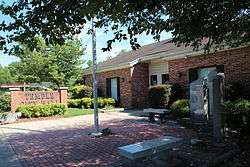
Temple City Hall | |
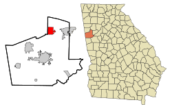 Location in Carroll County and the state of Georgia | |
| Coordinates: 33°44′9″N 85°1′38″W / 33.73583°N 85.02722°WCoordinates: 33°44′9″N 85°1′38″W / 33.73583°N 85.02722°W | |
| Country | United States |
| State | Georgia |
| Counties | Carroll, Haralson |
| Area | |
| • Total | 6.9 sq mi (17.9 km2) |
| • Land | 6.8 sq mi (17.6 km2) |
| • Water | 0.08 sq mi (0.2 km2) |
| Elevation | 1,171 ft (357 m) |
| Population (2010) | |
| • Total | 4,228 |
| • Density | 621/sq mi (239.9/km2) |
| Time zone | Eastern (EST) (UTC-5) |
| • Summer (DST) | EDT (UTC-4) |
| ZIP code | 30179 |
| Area code(s) | 770 |
| FIPS code | 13-75832[1] |
| GNIS feature ID | 0333205[2] |
| Website |
www |
Temple is a city in Carroll and Haralson counties in the U.S. state of Georgia. The population was 4,228 at the 2010 census,[3] up from 2,383 at the 2000 census.
Geography
Temple is located in northeastern Carroll County at 33°44′9″N 85°1′38″W / 33.73583°N 85.02722°W (33.735723, -85.027298).[4] A very small portion of the city extends west into Haralson County. U.S. Route 78 passes just south of the center of town, leading east 6 miles (10 km) to Villa Rica and west 7 miles (11 km) to Bremen. Interstate 20 passes through the southernmost part of the town, with access from Exit 19, and leads east 38 miles (61 km) to Atlanta and west 48 miles (77 km) to Oxford, Alabama. Carrollton, the county seat, is 12 miles (19 km) south via Highway 113.
According to the United States Census Bureau, Temple has a total area of 6.9 square miles (17.9 km2), of which 6.8 square miles (17.6 km2) is land and 0.08 square miles (0.2 km2), or 1.38%, is water.[3]
Demographics
| Historical population | |||
|---|---|---|---|
| Census | Pop. | %± | |
| 1890 | 246 | — | |
| 1900 | 397 | 61.4% | |
| 1910 | 711 | 79.1% | |
| 1920 | 621 | −12.7% | |
| 1930 | 573 | −7.7% | |
| 1940 | 624 | 8.9% | |
| 1950 | 676 | 8.3% | |
| 1960 | 788 | 16.6% | |
| 1970 | 864 | 9.6% | |
| 1980 | 1,520 | 75.9% | |
| 1990 | 1,870 | 23.0% | |
| 2000 | 2,383 | 27.4% | |
| 2010 | 4,228 | 77.4% | |
| Est. 2015 | 4,313 | [5] | 2.0% |
As of the census[1] of 2000, there were 2,383 people, 864 households, and 664 families residing in the city. The population density was 352.3 people per square mile (136.1/km²). There were 956 housing units at an average density of 141.3 per square mile (54.6/km²). The racial makeup of the city was 84.47% White, 13.72% African American, 0.25% Native American, 0.17% Asian, 0.04% Pacific Islander, 0.38% from other races, and 0.97% from two or more races. Hispanic or Latino of any race were 1.80% of the population.
There were 864 households out of which 39.4% had children under the age of 18 living with them, 57.2% were married couples living together, 12.6% had a female householder with no husband present, and 23.1% were non-families. 19.0% of all households were made up of individuals and 5.4% had someone living alone who was 65 years of age or older. The average household size was 2.76 and the average family size was 3.11.
In the city the population was spread out with 28.5% under the age of 18, 10.5% from 18 to 24, 32.8% from 25 to 44, 19.8% from 45 to 64, and 8.4% who were 65 years of age or older. The median age was 31 years. For every 100 females there were 91.7 males. For every 100 females age 18 and over, there were 96.9 males.
The median income for a household in the city was $39,063, and the median income for a family was $40,679. Males had a median income of $34,028 versus $22,963 for females. The per capita income for the city was $15,301. About 5.5% of families and 8.3% of the population were below the poverty line, including 13.4% of those under age 18 and 14.0% of those age 65 or over.
References
- 1 2 "American FactFinder". United States Census Bureau. Retrieved 2008-01-31.
- ↑ "US Board on Geographic Names". United States Geological Survey. 2007-10-25. Retrieved 2008-01-31.
- 1 2 "Geographic Identifiers: 2010 Demographic Profile Data (G001): Temple city, Georgia". U.S. Census Bureau, American Factfinder. Retrieved July 18, 2014.
- ↑ "US Gazetteer files: 2010, 2000, and 1990". United States Census Bureau. 2011-02-12. Retrieved 2011-04-23.
- ↑ "Annual Estimates of the Resident Population for Incorporated Places: April 1, 2010 to July 1, 2015". Retrieved July 2, 2016.
- ↑ "Census of Population and Housing". Census.gov. Retrieved June 4, 2015.
External links
Municipalities and communities of Carroll County, Georgia, United States | ||
|---|---|---|
| Cities |  | |
| Towns | ||
| Unincorporated community | ||
| Footnotes | ‡This populated place also has portions in an adjacent county or counties | |
Municipalities and communities of Haralson County, Georgia, United States | ||
|---|---|---|
| Cities |  | |
| Unincorporated communities | ||
| Footnotes | ‡This populated place also has portions in an adjacent county or counties | |