Tecumseh, Kansas
| Tecumseh | |
|---|---|
| Unincorporated community | |
|
Main part of Tecumseh. Church and Topeka & Shawnee County Public Library bookmobile stop and book drop-off box to the left. United States Postal Service office to the right. | |
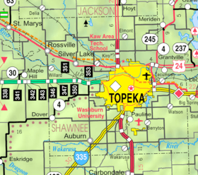 KDOT map of Shawnee County (legend) | |
 Tecumseh  Tecumseh | |
| Coordinates: 39°2′53″N 95°34′45″W / 39.04806°N 95.57917°WCoordinates: 39°2′53″N 95°34′45″W / 39.04806°N 95.57917°W | |
| Country | United States |
| State | Kansas |
| County | Shawnee |
| Township | Tecumseh |
| Elevation[1] | 912 ft (278 m) |
| Time zone | CST (UTC-6) |
| • Summer (DST) | CDT (UTC-5) |
| ZIP code | 66542 |
| Area code | 785 |
| FIPS code | 20-70075 [1] |
| GNIS ID | 478796 [1] |

Tecumseh is an unincorporated community in Shawnee County, Kansas, United States. It is situated along the Kansas River. The community and township are both named for the famous Shawnee chief.[2][3]
History
Tecumseh dates from the 1850s when Thomas Stinson settled in the area and had a townsite platted by September 1, 1854.[2] It was settled by pro-southern partisans in the turbulent days when Kansas was a territory. For a time it served as the pro-southern capital of the territory and prospered, even having a newspaper. The town's post office opened in March 1855.[4] In 1886, the brick courthouse was sold for $500 and removed.[2] Once the northern/southern political issues were settled at the conclusion of the Civil War, the village rapidly declined, and it survived as a mere ghost of itself for the next ninety years.
Construction of the Kansas Power & Light Co. power plant in 1924 and 1925.[2] In 1958, Du Pont established a cellophane plant east of town created a renaissance of sorts.[2] As Topeka grew in the 1950s, Tecumseh again started to grow, this time as a suburb of Topeka. The old townsite grew and numerous suburban housing subdivisions developed in the vicinity.
Geography
Tecumseh is located at 39°02′53″N 95°34′45″W / 39.04806°N 95.57917°W (39.0480558, -95.5791453),[1] in Section 36, Township 11 south, Range 16 east. It is situated south of the Kansas River between Tecumseh Creek to the east and Stinson Creek to the west. Contained entirely within Tecumseh Township, it is about 2 miles east of the Topeka city limits.[5] U.S. Route 40 passes the south side of Tecumseh. A BNSF rail line—running between Lawrence and Topeka—passes north of the town between it and the river.
Demographics
Tecumseh is part of the Topeka, Kansas Metropolitan Statistical Area. Although official populations are not compiled for unincorporated places, the population of the surrounding Tecumseh Township was 7,822 in the 2000 census.
Economy
The community includes a public school (part of USD 450), a church, a post office, a large electrical generating plant and a cellophane factory.[6]
References
- 1 2 3 4 "US Board on Geographic Names". United States Geological Survey. 2007-10-25. Retrieved 2008-01-31.
- 1 2 3 4 5 Bird, Roy D.; Douglass W. Wallace (1976). Robert W. Richmond & Joseph W. Snell, ed. Witness of the Times: A History of Shawnee County. Topeka, Kansas: Shawnee County Historical Society. pp. 351–352. ISBN 0-916934-03-9.
- ↑ Heim, Michael (2007). Exploring Kansas Highways. p. 49.
- ↑ "Kansas Post Offices Database". Kansas State Historical Society. Retrieved 2008-02-09. Containing information taken from Baughman, Robert W. Kansas Post Offices, May 29, 1828–August 3, 1961. Kansas Postal History Society.
- ↑ "KDOT County Maps". 1994. Retrieved 2008-02-09.
- ↑ Japanese firm to invest $30 million in Tecumseh cellophane plant, the last plant of its kind in U.S.; The Topeka Capital Journal; May 18, 2016.
External links
Municipalities and communities of Shawnee County, Kansas, United States | ||
|---|---|---|
| Cities | 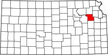 | |
| CDP | ||
| Unincorporated communities | ||
| Ghost town | ||
| Townships | ||
| Footnotes | ‡This populated place also has portions in an adjacent county or counties | |