Tauá
| Tauá | |
|---|---|
| Municipality and city | |
 Municipal location | |
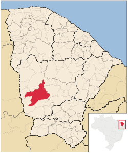
 Tauá Location in Brazil | |
| Coordinates: BR 6°0′10″S 40°17′34″W / 6.00278°S 40.29278°W | |
| Country |
|
| Region | Nordeste |
| State | Ceará |
| Mesoregion | Sertoes Cearenses |
| Area | |
| • Total | 1,551.431 sq mi (4,018.188 km2) |
| Elevation | 1,319 ft (402 m) |
| Population (2010) | |
| • Total | 55,755 |
| • Density | 35.9/sq mi (13.88/km2) |
| Time zone | UTC -3 |
Tauá is a municipality in the state of Ceará in the Northeast region of Brazil. In 2010 it had a total population of 55,755 people.[1] It is one of the largest municipalities in the state, with an area of 4,018.188 square kilometres (1,551.431 sq mi).
History
The toponymy of Tauá refers to an indigenous word meaning "yellow clay and loam" in the Tupi language.[2] Its origins date from at least the early 18th century. On December 14, 1801, Ouvidor Gregório José da Silva went to the small settlement of Tauá to raise the site to a town.[3] On May 3, 1802, it became a formal settlement.[4] On August 17, 1832, it was given freguesia status.[2] On December 2, 1889, the site was renamed São João do Príncipe dos Inhamuns. It received the classification of city on August 2, 1929, returning to its former name.[5]
Geography
The city is located 337 kilometres (209 mi) away from the capital of Ceará State, Fortaleza. The town lies along BR-020, 60.8 kilometres (37.8 mi) by road northeast of Parambu. Districts of the municipality include Marrecas, Barra Nova, Trici, Marruás, Carrapateiras, Inhamuns, and Santa Tereza. The Jaguaribe River's headwaters are located in the Tauá districts of Trici and Carrapateiras.[6] At Tauá, the Jaguaribe is rather narrow, 50–100 metres (160–330 ft) in width, and is sandy. The course of the river between Tauá to the mouth of the Salgado River is approximately 250 kilometres (160 mi).[7]
The biggest natural landmark is the mountain range, Serrote Quinamuiú. It became protected by municipal law in 2005. In 2011, the unauthorized extraction of precious stones, such as amethyst, became a matter of concern to environmentalists and the local government as the use of dynamite caused serious damage to the mountain's physical structure.[8]
Economy
According to the government statistics in 1996, the per capita income in Tauá was far below the minimum established income. Carrapateiras suffers from overgrazing and poor market accessibility.[6] The municipality contains the first solar photovoltaic power plant to generate electricity on a commercial scale in Brazil, MPX Tauá, inaugurated in August 2011. Tauá has three local radio stations, Rádio Difusora dos Inhamuns, Rádio Trici FM, and Cultura dos Inhamuns 960.[9]
Landmarks
The municipality has three paleontological and archeological sites which can be visited, but can only be explored by researchers and professionals with a permit. A donation by Sergeant Major José Rodrigues de Matos enabled the construction of a chapel dedicated to Nossa Senhora do Rosário (Our Lady of the Rosary), located in the municipal cemetery. Igreja de Nossa Senhora do Rosário (Church of Our Lady of the Rosary) was inaugurated on October 17, 1762. Originally constructed with a cylindrical domed roof, it was expanded in 1906. The structure is listed as a protected cultural monument by the Brazilian government. The Igreja de Jesus (Church of Jesus) in the Tauá district of Marrecas was built in the early eighteenth century, around 1717. The first parish priest was Father Fructuoso Ribeiro Dias.[2]
Culture
The feast of Jesus, Mary and Joseph is held every year in April, one of the biggest religious events in the state of Ceará. Our Lady of the Rosary, whose day is celebrated on October 7, is the town's patron saint.[5]
Notable people
- Fausto Barreto - philologist, journalist, teacher and Brazilian politician
- Jovita Feitosa - Feitosa, considered to be a martyr of feminism, was born in Tauá. Though she attempted to fight in the Paraguayan War, she was denied permission to join the battlefront.[10][11]
- Vicente Fialho - Minister of Mines and Energy and mayor of Fortaleza
- Joaquim Pimenta - Lawyer and Minister of Labour
See also
References
- ↑ Censo Populacional 2010 (in Portuguese), Instituto Brasileiro de Geografia e Estatística (IBGE), 29 November 2010
- 1 2 3 "Paróquia Nossa Senhora do Rosário - Tauá" (in Portuguese). Diocese of Crateus. Retrieved 16 October 2012.
- ↑ Santos, Arnaldo; Leitão, Juarez (2002). Verbo cívico: visão histórico-sociológica da Assembléia Legislativa do Ceará. Expert Editora. Retrieved 12 October 2012.
- ↑ Chandler, Billy Jaynes (1972). Latin American Monographs. University of Florida Press, 1957-c1984. p. 37. Retrieved 15 October 2012.
- 1 2 "Historia de Tauá" (in Portuguese). Government of Tauá. Retrieved 12 October 2012.
- 1 2 Gaiser, Thomas (2003). Global Change and Regional Impacts: Water Availability and Vulnerability of Ecosystems and Society in the Semiarid Northeast of Brazil. Springer. pp. 71, 76, 309–. ISBN 978-3-540-43824-3. Retrieved 14 October 2012.
- ↑ Pamphlets, Raymond C. (1902). Pamphlets on Biology: Kofoid collection (Public domain ed.). Proceedings of the United States National Museum. pp. 507–. Retrieved 15 October 2012.
- ↑ "Serrote do Quinamuiú em debate". Diario do Nordeste. March 2, 2011. Retrieved 16 October 2012.
- ↑ "Cultura do Inhamuns 960". RÁDIO CULTURA DOS INHAMUNS. Retrieved 16 October 2012.
- ↑ "Antônia Alves Feitosa, a Jovita Feitosa" (in Portuguese). Federal University of Campina Grande. Retrieved 17 October 2012.
- ↑ Moraes, Sana; Matos, Karina Caroline Oliveira (August 3, 2012). "Jovita Feitosa venceu o preconceito e lutou nas forças armadas" (in Portuguese). Cidade Verde. Retrieved 17 October 2012.
External links
Capital: Fortaleza | |||||||||||||||||||||||||||||||||||||
|  | ||||||||||||||||||||||||||||||||||||
|
| |||||||||||||||||||||||||||||||||||||
| |||||||||||||||||||||||||||||||||||||
| |||||||||||||||||||||||||||||||||||||
| |||||||||||||||||||||||||||||||||||||
| |||||||||||||||||||||||||||||||||||||
Coordinates: 6°00′10″S 40°17′34″W / 6.00278°S 40.2928°W