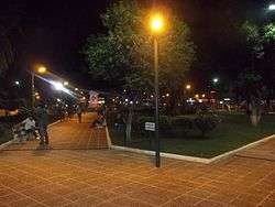
Tartagal, Salta
| Tartagal | ||
|---|---|---|
| City | ||
 | ||
| ||
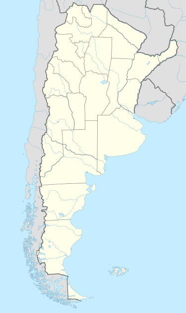 Tartagal Location of Tartagal in Argentina | ||
| Coordinates: 22°30′S 63°50′W / 22.500°S 63.833°WCoordinates: 22°30′S 63°50′W / 22.500°S 63.833°W | ||
| Country | Argentina | |
| Province | Salta | |
| Department | San Martín | |
| Founded | 1924 | |
| Government | ||
| • Mayor | Sergio Napoleón Leavy (Partido Frente para la Victoria) | |
| Area | ||
| • Total | 3,015 km2 (1,164 sq mi) | |
| Elevation | 490 m (1,610 ft) | |
| Population (2012) | ||
| • Total | 69,696 | |
| • Density | 23/km2 (60/sq mi) | |
| Time zone | ART (UTC-3) | |
| CPA base | A4560 | |
| Dialing code | +54 3875 | |
| Climate | Cwa | |
| Website | Tartagal website | |

Tartagal (Spanish pronunciation: [tartaˈɣal]) is a city in the north of the province of Salta, Argentina, 365 km from the provincial capital. It has over 60,000 inhabitants as per the 2001 census [INDEC], and it is the head town of the General José de San Martín Department (with about 3/4 of its population). It is crossed by the river of the same name.
Tartagal is located in an area of major economic importance for the province, within Argentina's second largest natural gas reservoir, and at a crossroads for trade in the Mercosur (being only 55 km from the border with Bolivia and 100 km from Paraguay). The area produces 25% of the oil and about 16% of the natural gas in Argentina.
History
Tartagal derives from the tártago plant (Euphorbia lathyris, a kind of spurge). The area of modern Tartagal appears with this name in legal documents for the first time in 1853. At the time the area belonged to the Tarija Department, Bolivia. The foundation date of the town, however, is acknowledged as June 13, 1924; the municipality was created soon afterwards, and Tartagal attained city status only on September 22, 1949.
The Argentine Army has the 17th Jungle Cazadores Company (Compañía de Cazadores de Monte 17) based at Tartagal.[1]
Petroleum was discovered here at the beginning of the 20th century. Since 1926 the state-owned oil company YPF employed or indirectly supported most of the local population. In 1992 the company was privatized (becoming Repsol-YPF) and 90% of its workers were fired, prompting violent social conflicts and, a few years later, the appearance of piquetero (unemployed workers) movements, similarly to what happened also in other oil-producing areas like Cutral-Co, Neuquén, and in the neighboring General Mosconi.
On November 12, 1966 at a solar eclipe several sounding rockets were launched from Tartagal for solar research.[2]
On February 9, 2009, heavy rains caused the Tartagal River to break its banks and flood much of the city, resulting in 11 casualties.[3]
Climate
| Climate data for Tartagal, Salta (1991–2000, extremes 1970–present) | |||||||||||||
|---|---|---|---|---|---|---|---|---|---|---|---|---|---|
| Month | Jan | Feb | Mar | Apr | May | Jun | Jul | Aug | Sep | Oct | Nov | Dec | Year |
| Record high °C (°F) | 42.2 (108) |
42.6 (108.7) |
39.1 (102.4) |
36.1 (97) |
35.6 (96.1) |
32.8 (91) |
37.7 (99.9) |
41.0 (105.8) |
43.0 (109.4) |
43.8 (110.8) |
44.8 (112.6) |
42.6 (108.7) |
44.8 (112.6) |
| Average high °C (°F) | 31.5 (88.7) |
30.5 (86.9) |
28.7 (83.7) |
25.5 (77.9) |
23.4 (74.1) |
21.7 (71.1) |
21.6 (70.9) |
25.8 (78.4) |
28.8 (83.8) |
30.9 (87.6) |
30.7 (87.3) |
32.6 (90.7) |
27.5 (81.5) |
| Daily mean °C (°F) | 25.4 (77.7) |
24.4 (75.9) |
23.2 (73.8) |
20.4 (68.7) |
18.1 (64.6) |
15.5 (59.9) |
14.6 (58.3) |
17.8 (64) |
21.0 (69.8) |
23.7 (74.7) |
24.1 (75.4) |
26.0 (78.8) |
21.0 (69.8) |
| Average low °C (°F) | 20.5 (68.9) |
19.6 (67.3) |
19.6 (67.3) |
16.7 (62.1) |
13.6 (56.5) |
11.1 (52) |
8.6 (47.5) |
10.1 (50.2) |
13.7 (56.7) |
17.2 (63) |
18.0 (64.4) |
20.1 (68.2) |
15.6 (60.1) |
| Record low °C (°F) | 9.7 (49.5) |
11.2 (52.2) |
8.0 (46.4) |
4.6 (40.3) |
2.0 (35.6) |
−2.6 (27.3) |
−5.9 (21.4) |
−5.4 (22.3) |
0.1 (32.2) |
2.4 (36.3) |
5.4 (41.7) |
10.2 (50.4) |
−5.9 (21.4) |
| Average precipitation mm (inches) | 182.8 (7.197) |
179.5 (7.067) |
191.5 (7.539) |
44.8 (1.764) |
31.6 (1.244) |
5.3 (0.209) |
3.5 (0.138) |
5.7 (0.224) |
31.3 (1.232) |
46.2 (1.819) |
130.4 (5.134) |
117.8 (4.638) |
970.4 (38.205) |
| Average relative humidity (%) | 74.3 | 77.7 | 82.0 | 81.9 | 82.0 | 77.8 | 67.4 | 58.2 | 52.3 | 57.7 | 66.6 | 67.9 | 71.1 |
| Source #1: Portal Informativo de Salta[4] | |||||||||||||
| Source #2: Oficina de Riesgo Agropecuario (record highs and lows)[5] | |||||||||||||
References
- ↑ Argentine Army official website - Structure (search "Infanteria") (Spanish)
- ↑ http://www.astronautix.com/sites/tartagal.htm
- ↑ BBC news
- ↑ "Clima de la Provincia de Salta" (in Spanish). Government of Salta. Retrieved June 22, 2015.
- ↑ "Tartagal, Salta". Estadísticas meteorológicas decadiales (in Spanish). Oficina de Riesgo Agropecuario. Retrieved June 22, 2015.
Sources
External links
- (Spanish)Municipality of Tartagal - Official website.
- Municipal information: Municipal Affairs Federal Institute (IFAM), Municipal Affairs Secretariat, Ministry of Interior, Argentina. (Spanish)