Talata Ampano
| Talata Ampano | |
|---|---|
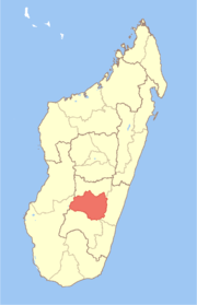
 Talata Ampano Location in Madagascar | |
| Coordinates: 21°33′S 47°2′E / 21.550°S 47.033°E | |
| Country |
|
| Region | Haute Matsiatra |
| District | Fianarantsoa II |
| Elevation[1] | 1,165 m (3,822 ft) |
| Population (2001)[2] | |
| • Total | 15,000 |
| Time zone | EAT (UTC3) |
Talata Ampano is a town and commune in Madagascar. It belongs to the district of Fianarantsoa II, which is a part of Haute Matsiatra Region. The population of the commune was estimated to be approximately 15,000 in 2001 commune census.[2]
Primary and junior level secondary education are available in town. The majority 86% of the population of the commune are farmers, while an additional 5% receives their livelihood from raising livestock. The most important crop is rice, while other important products are vegetables, cassava, sweet potatoes and tomato. Industry and services provide employment for 6% and 2% of the population, respectively. Additionally fishing employs 1% of the population.[2]
References and notes
- ↑ Estimated based on DEM data from Shuttle Radar Topography Mission
- 1 2 3 "ILO census data". Cornell University. 2002. Retrieved 2008-05-01.
Coordinates: 21°33′S 47°2′E / 21.550°S 47.033°E