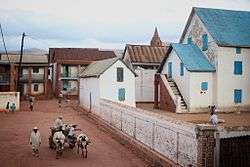
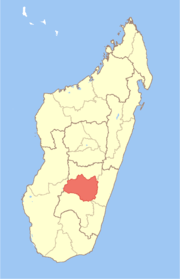
Soatanana
| Soatanana | |
|---|---|
 | |
 Soatanana Location in Madagascar | |
| Coordinates: 21°23′S 46°55′E / 21.383°S 46.917°E | |
| Country |
|
| Region | Haute Matsiatra |
| District | Fianarantsoa II |
| Elevation[1] | 1,141 m (3,743 ft) |
| Population (2001)[2] | |
| • Total | 10,000 |
| Time zone | EAT (UTC3) |
Soatanana is a town and commune in Madagascar. It belongs to the district of Fianarantsoa II, which is a part of Haute Matsiatra Region. The population of the commune was estimated to be approximately 10,000 in 2001 commune census.[2]
In addition to primary schooling the town offers secondary education at both junior and senior levels. The majority 95% of the population of the commune are farmers. The most important crops are rice and bambara groundnut, while other important agricultural products are maize, cassava and potatoes. Services provide employment for 5% of the population.[2]
References and notes
- ↑ Estimated based on DEM data from Shuttle Radar Topography Mission
- 1 2 3 "ILO census data". Cornell University. 2002. Retrieved 2008-05-01.
| Wikimedia Commons has media related to Soatanana. |
Coordinates: 21°23′S 46°55′E / 21.383°S 46.917°E
This article is issued from Wikipedia - version of the 1/24/2015. The text is available under the Creative Commons Attribution/Share Alike but additional terms may apply for the media files.