Taagepera Castle


The Taagepera Castle (German name: Wagenküll) is a mansion in Taagepera village, Helme Parish, Valga County, Estonia.
History
The mansion was first mentioned in the 16th century.
During the Polish rule and Swedish rule of Estonia, the mansion belonged to the Rehbinder family. In 1674, the mansion was sold to the Swedish major Otto von Stackelberg.[1][2]
In 1819, the almost bankrupt mansion was sold to Bernhard Heinrich von Stryk (1746-1829), who married Anna Elisabeth von Oetting (1763-1825) in 1782. The last owner of the mansion was Bernhard Heinrich von Stryk's great-grandson Hugo von Stryk, who lost the mansion in the 1919 land reform.
Mansion complex
Mansion house

The current mansion house was designed by the Estonian architect Otto Wildau in the early 20th century. The western corner of the house includes a 40-metre tall tower. Because of the large size of the mansion house, it is commonly called a castle instead of a mansion house.
After the Estonian War of Independence in 1919, the mansion house was converted into a sanatorium. In the late 1930s, a new sanatorium house was built, designed by the architect Alar Kotli. The mansion house served as a sanatorium until 2000. From 2002, the mansion house serves as a hotel.
Graveyard
In the late 19th century, a family graveyard was constructed near the mansion house. Among those buried there are:
- Katharina Mathilde von Stryk (née Rogge), born 15 July 1815 - died 13 April 1892
- Bernhard Heinrich Konstantin von Stryk, born 29 July 1827 - died 5 January 1912
Stamps
In 1933, the Eesti Post designed a series of four stamps with an anti-tuberculosis thema, of which the blue/red 10 cent stamp and the dark blue/red 20-cent stamp depict the Taagepera mansion house (at that time a sanatorium). A new stamp depicting the Taagepera mansion house was designed in 2006.
See also
Gallery
 Exterior view.
 Lobby.
 Lobby.
 Lobby.
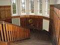 Stairway to the second floor.
 Billiards room on the second floor.
 Jahisaal.
 Jahisaal.
 Jahisaal.
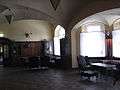 Jahisaal.
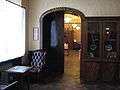 Jahisaal.
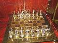 Jahisaal - a chess board in the hall.
 Anna Sophie restaurant.
 Anna Sophie restaurant.
 Anna Sophie restaurant.
 Anna Sophie restaurant - castle cat.
 Hugo Saal.
 Hugo Saal.
 Rüütli Saal.
 Rüütli Saal.
 Stairway in the tower.
 Observation room in the tower.
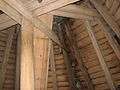 Stairway from the second-last floor to the last floor in the tower.
 Last floor in the tower.
 View from the last floor in the tower.
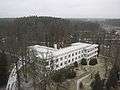 View from the last floor in the tower.
 View from the last floor in the tower.
 View from the last floor in the tower.
References
- ↑ Genealogisches Handbuch der batlischen Ritterschaften, Estland, Tei 2.2, Görlitz 1930, pp. 292-
- ↑ Heinrich von Hagemeister: Materialien zu einer Geschichte der Langüter Livlands T. 1-2, Riga 1836/1837, pp. 366-367
External links
| Wikimedia Commons has media related to Taagepera Castle. |
| Harju County | |
|---|---|
| Hiiu County | |
| Ida-Viru County | |
| Järva County | |
| Jõgeva County | |
| Lääne County | |
| Lääne-Viru County | |
| Pärnu County | |
| Põlva County | |
| Rapla County | |
| Saare County | |
| Tartu County | |
| Valga County | |
| Viljandi County | |
| Võru County | |
Coordinates: 57°59′35″N 25°39′58″E / 57.99306°N 25.66611°E