Sykesville, Pennsylvania
| Sykesville, Pennsylvania | |
|---|---|
| Borough | |
 Sykesville, Pennsylvania | |
| Coordinates: 41°02′58″N 78°49′12″W / 41.04944°N 78.82000°WCoordinates: 41°02′58″N 78°49′12″W / 41.04944°N 78.82000°W | |
| Country | United States |
| State | Pennsylvania |
| County | Jefferson |
| Settled | 1859 |
| Incorporated | 1907 |
| Government | |
| • Type | Borough Council |
| Area | |
| • Total | 1.6 sq mi (4 km2) |
| Elevation | 1,352 ft (412 m) |
| Population (2000) | |
| • Total | 1,246 |
| • Density | 784.7/sq mi (303.0/km2) |
| Time zone | Eastern (EST) (UTC-5) |
| • Summer (DST) | EDT (UTC-4) |
| Zip code | 15865 |
| Area code(s) | 814 |
Sykesville is a borough in Jefferson County, Pennsylvania, United States. The population was 1,246 at the 2000 census. The borough was named for Jacob B. Sykes, an early resident.[1]
Sykesville is the birthplace of Olga Madar (1915–1996), first woman to be a vice-president in the United Auto Workers (1970) and founder of the Coalition of Labor Union Women in 1974.
Geography
Sykesville is located at 41°2′58″N 78°49′12″W / 41.04944°N 78.82000°W (41.049543, -78.820134).[2]
According to the United States Census Bureau, the borough has a total area of 1.6 square miles (4.1 km2), all of it land.
The borough is bisected by US 119.
Demographics
| Historical population | |||
|---|---|---|---|
| Census | Pop. | %± | |
| 1910 | 1,756 | — | |
| 1920 | 2,507 | 42.8% | |
| 1930 | 2,103 | −16.1% | |
| 1940 | 2,044 | −2.8% | |
| 1950 | 1,652 | −19.2% | |
| 1960 | 1,479 | −10.5% | |
| 1970 | 1,311 | −11.4% | |
| 1980 | 1,537 | 17.2% | |
| 1990 | 1,387 | −9.8% | |
| 2000 | 1,246 | −10.2% | |
| 2010 | 1,157 | −7.1% | |
| Est. 2015 | 1,135 | [3] | −1.9% |
| Sources:[4][5][6] | |||
As of the census[5] of 2000, there were 1,246 people, 548 households, and 340 families residing in the borough. The population density was 784.7 people per square mile (302.6/km²). There were 604 housing units at an average density of 380.4 per square mile (146.7/km²). The racial makeup of the borough was 99.44% White, 0.24% African American, 0.16% Native American, and 0.16% from two or more races. Hispanic or Latino of any race were 0.24% of the population.
There were 548 households, out of which 29.4% had children under the age of 18 living with them, 47.1% were married couples living together, 10.8% had a female householder with no husband present, and 37.8% were non-families. 33.9% of all households were made up of individuals, and 17.9% had someone living alone who was 65 years of age or older. The average household size was 2.27 and the average family size was 2.92.
In the borough the population was spread out, with 24.2% under the age of 18, 7.1% from 18 to 24, 27.4% from 25 to 44, 20.7% from 45 to 64, and 20.6% who were 65 years of age or older. The median age was 40 years. For every 100 females there were 94.1 males. For every 100 females age 18 and over, there were 92.9 males.
The median income for a household in the borough was $26,719, and the median income for a family was $34,375. Males had a median income of $30,597 versus $19,773 for females. The per capita income for the borough was $14,398. About 13.1% of families and 17.1% of the population were below the poverty line, including 23.4% of those under age 18 and 11.0% of those age 65 or over.
References
- ↑ McKnight, William James (1917). Historical. J.H. Beers. p. 490.
- ↑ "US Gazetteer files: 2010, 2000, and 1990". United States Census Bureau. 2011-02-12. Retrieved 2011-04-23.
- ↑ "Annual Estimates of the Resident Population for Incorporated Places: April 1, 2010 to July 1, 2015". Retrieved July 2, 2016.
- ↑ "Census of Population and Housing". U.S. Census Bureau. Retrieved 11 December 2013.
- 1 2 "American FactFinder". United States Census Bureau. Retrieved 2008-01-31.
- ↑ "Incorporated Places and Minor Civil Divisions Datasets: Subcounty Resident Population Estimates: April 1, 2010 to July 1, 2012". Population Estimates. U.S. Census Bureau. Retrieved 11 December 2013.
Municipalities and communities of Jefferson County, Pennsylvania, United States | ||
|---|---|---|
| Boroughs | 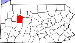 | |
| Townships | ||
| CDP | ||
| Unincorporated communities |
| |
| Footnotes | ‡This populated place also has portions in an adjacent county or counties | |