Susan River (California)
| Susan River | |
| stream | |
 | |
| Country | United States |
|---|---|
| State | California |
| Region | Lassen County |
| Tributaries | |
| - left | Piute Creek, Willow Creek |
| Cities | Susanville, Johnstonville, Litchfield |
| Source | Caribou Lake |
| - location | 11 miles west of Norvell in the Lassen National Forest, Sierra Nevada, California |
| - elevation | 6,571 ft (2,003 m) |
| - coordinates | 40°30′10″N 121°09′51″W / 40.50278°N 121.16417°W [1] |
| Mouth | Honey Lake |
| - elevation | 3,993 ft (1,217 m) [1] |
| - coordinates | 40°20′11″N 120°15′27″W / 40.33639°N 120.25750°WCoordinates: 40°20′11″N 120°15′27″W / 40.33639°N 120.25750°W [1] |
| Length | 67 mi (108 km) |
| Basin | 1,170 sq mi (3,030 km2) [2] |
| Discharge | for Susanville, 20 mi (32 km) from the mouth |
| - average | 88 cu ft/s (2 m3/s) |
| - max | 5,850 cu ft/s (166 m3/s) |
| - min | 0.6 cu ft/s (0 m3/s) |
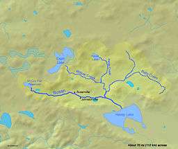 | |
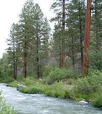
The Susan River is a northeastern California river of approximately 67 miles (108 km) length[3] that drains from an arid plateau of volcanic highlands along the Great Basin Divide to intermittent Honey Lake. The river flows from eastern Lassen County from east of Lassen Volcanic National Park generally east past Susanville and emerging into a ranching valley to enter the north end of Honey Lake. Along with Fredonyer Pass, the Susan River is the northern boundary of the Sierra Nevada.[4]
History
Susan River and the town of Susanville was named for Susan Roop, daughter of early settler Issac Roop, in 1857.[1][5]
Watershed
Susan River begins at Caribou Lake at elevation 6,571 feet (2,003 m),[3] which is dammed by Caribou Lake 234 Dam. It flows eastward, curving southeasterly as it enters the Great Basin where it is joined on the left by Bridge Creek and dammed to form McCoy Flat Reservoir approximately 11 miles northwest of Susanville. It next receives in order from the right (heading downstream) Crazy Harry Gulch, Willard Creek, and Williams Creek before entering Susanville, where it receives Piute Creek from the left. Below Susanville it receives from the left Gold Run Creek, Lassen Creek and Sand Slough, the latter at Johnstonville. At Johnstonville the Lake Leavitt Inlet Canal diverts Susan River flows south to Lake Leavitt. After being joined by Willow Creek from the left, the Susan River passes below Litchfield and is extensively modified by a complicated system of canals and levees for irrigation of the surrounding ranching areas. Next the river reaches the Honey Lake State Wildlife Area and finally Honey Lake itself at elevation 3,993 feet (1,217 m).
References
- 1 2 3 4 U.S. Geological Survey Geographic Names Information System: Susan River
- ↑ http://webcache.googleusercontent.com/search?q=cache:z5_bbV52_O0J:honeylakevalleyrcd.us/wp-content/uploads/2012/02/SRWMS-BBQ-Powerpoint-Presentation-6-11-12.pptx+&cd=1&hl=en&ct=clnk&gl=us
- 1 2 U.S. Geological Survey. National Hydrography Dataset high-resolution flowline data. The National Map, accessed March 17, 2011
- ↑ "Subsection M261Eb: Fredonyer Butte – Grizzly Peak". Archived from the original on 2010-12-05. Retrieved 2014-02-22.
- ↑ William Bright, Erwin Gustav Gudde (1998). 500 California place names: their origin and meaning. University of California Press. p. 147. ISBN 978-0-520-21271-8. Retrieved 2011-12-29.