Sumner and New Lots Avenues Lines
| B15 | |||
|---|---|---|---|
|
Sumner Avenue Line New Lots Avenue Line Brooklyn−JFK Airport | |||
|
| |||
| Overview | |||
| System | MTA Regional Bus Operations | ||
| Operator | New York City Transit Authority | ||
| Garage | East New York Depot | ||
| Route | |||
| Locale | Brooklyn | ||
| Start | Bedford–Stuyvesant – Woodhull Medical Center | ||
| Via | Marcus Garvey Blvd (southbound) / Lewis Avenue (northbound), East 98th Street, New Lots Avenue, Linden Boulevard, Conduit Avenue[1] | ||
| End | JFK Airport, Queens – Terminal 5 | ||
| Service | |||
| Operates | All times except late nights[1] | ||
| Daily ridership | 7,265,055 (2014)[2] | ||
| Fare | $2.75 (MetroCard or coins) | ||
| Cash | Coins only (exact change required) | ||
| Transfers | Yes | ||
| Timetable | B15 | ||
| |||
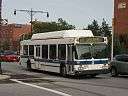
The Sumner Avenue Line and New Lots Avenue Line were two streetcar lines in Brooklyn, New York City, running mainly along Marcus Garvey Boulevard (formerly Sumner Avenue), East 98th Street, and New Lots Avenue between northern Bedford–Stuyvesant and New Lots. Originally streetcar lines, the two lines were combined as a bus route in 1947. That bus route became the present B15 Marcus Garvey Boulevard/New Lots Avenue service, operated by MTA New York City Bus' East New York Depot in East New York. The B15 continues east from New Lots to John F. Kennedy International Airport in Queens.
Route description
The B15 bus route runs between the Woodhull Medical and Mental Health Center and Flushing Avenue (J M) subway station in Bedford–Stuyvesant, and John F. Kennedy International Airport's Terminal 5 in Queens. Alternate buses during rush hours and weekends short turn at Drew Street/Elderts Lane on Linden Boulevard in Spring Creek, at the border with Lindenwood, Queens.[1][3][4]
The B15 bus route heads south through Bedford–Stuyvesant along Marcus Garvey Boulevard (southbound) and Lewis Avenue (northbound). After crossing Fulton Street, buses use a number of streets through Crown Heights and Ocean Hill, eventually turning south on Ralph Avenue and southeast on East 98th Street. In Brownsville and East New York, buses head east on Hegeman Avenue and New Lots Avenue, jogging south to Linden Boulevard and merging onto Conduit Avenue after entering Queens. B15 buses then serve several areas of JFK Airport and end at Terminal 5. Between the Brooklyn-Queens border and JFK Airport, B15 buses run non-stop.[1][3]
Between the 1990s and September 2013, the short-turn B15 Spring Creek terminus was a separate branch, directly serving the Brooklyn General Mail Facility via a turnaround loop at the north end of the facility south of Linden Boulevard. The JFK and Postal Facility branches were combined during midday and overnight hours.[4][5] The loop is still served by terminating B14 and B20 buses, and through B13 service to Wyckoff Heights Medical Center in Bushwick or the Gateway Center in the southern portion of Spring Creek.[3][4]
Originally named after abolitionist Charles Sumner, Sumner Avenue was renamed Marcus Garvey Avenue in 1987, and later Marcus Garvey Boulevard after Pan-Africanism proponent Marcus Garvey.[6][7][8]
History
Sumner Avenue Line
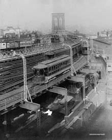
The Yates Avenue and Flatbush Railroad was organized in 1881 to build a branch of the Broadway Railroad, beginning at Broadway and Yates Avenue (present-day Marcus Garvey Boulevard) in Bedford–Stuyvesant, continuing south on Yates to Fulton Street, then east on Fulton, where it ran over the Brooklyn City Rail Road's Fulton Street Line to Troy Avenue, and continued south on Troy to end at Bergen Street.[9] The Broadway Railroad leased the line on December 31, 1881[10] The Brooklyn, Queens County and Suburban Railroad, owned by the Long Island Traction Company (later the Brooklyn Rapid Transit Company or BRT), leased the Broadway Railroad in early 1894, and the line was electrified in late October.[11] After the Nassau Electric Railroad, which owned the Bergen Street Line, was leased to the Brooklyn Heights Railroad (another BRT property) in 1899, Sumner Avenue cars were extended south/east along the Bergen Street, Saint Johns Place, and Ralph Avenue lines to Brownsville and west along the Bergen Street Line to Hamilton Ferry in Red Hook. The BRT would become the Brooklyn–Manhattan Transit Corporation (BMT) in 1923.[12]
Conversion to bus service
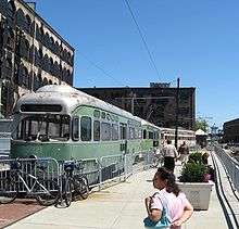
Beginning in the 1920s many streetcar lines in Brooklyn and the rest of the city began to be replaced by buses, particularly after the unification of city's three primary transit companies (including the BMT) under municipal operations in June 1940.[13][14] The New Lots Avenue Line was converted to buses in mid-1941, running from the Canarsie Depot at Rockaway Avenue and Hegeman Avenue continuing east along Hegeman Avenue and Linden Boulevard to Atkins Avenue/Berriman Street in East New York.[13][15][16] The service was assigned the B10 designation.[13][15][17] On July 8, 1947, the B10 was extended to replace Sumner Avenue trolley service. The Sumner route was cut back from Williamsburg Bridge Plaza to its current terminal at Broadway and Sumner Avenue with direct Bedford–Stuyvesant-Red Hook service unreplaced.[15][18] Sumner trolley service was fully eliminated in 1949.[15]
On September 29, 1963, several Brooklyn streets including Sumner Avenue were turned into one-way streets; Sumner Avenue would become southbound only. Northbound B10 buses were rerouted onto Lewis Avenue at this time.[19] By this time, the B10 had been extended east along Linden Boulevard to Drew Street/Elderts Lane in New Lots/Spring Creek, near the Brooklyn-Queens border.[17][19] This extension had been proposed around 1960 to serve the Cypress Hills and Louis Heaton Pink public housing complexes in New Lots.[20] The bus would serve Brooklyn General Mail Facility in Spring Creek when it opened in 1991.[21][22] In 1993, the route was extended to its current terminal at John F. Kennedy International Airport's Terminal 4 in Jamaica, Queens. When the route was extended to Kennedy Airport it was redesignated as the B15 (the previous designation for a route between City Hall and Downtown Brooklyn)[17][23] to avoid confusion with the Q10, an existing route serving the airport, at the time operated by Green Bus Lines (now part of MTA Bus Company).
On April 11, 2004, 24-hour service was added to the B15 between Brooklyn and JFK Airport. At the same time, service to all JFK terminals except Terminal 4 was replaced by AirTrain JFK.[24][25]
On October 12, 2009, buses on the B15 were equipped with luggage racks, as part of a ten-bus pilot program on airport bus services to improve passenger flow.[26][27][28]
On May 30, 2012, due to construction at Terminal 4, the B15 started terminating at a new stop at Terminal 5, near the former Terminal 6.[25][29]
On September 8, 2013, B15 buses stopped directly serving the Brooklyn General Mail Facility loop due to low ridership.[4][5]
References
- 1 2 3 4 B15 bus schedule MTA Regional Bus Operations.
- ↑ "Facts and Figures". mta.info. 2011-08-28. Retrieved 2016-01-19.
- 1 2 3 "Brooklyn Bus Map" (PDF). web.mta.info. Metropolitan Transportation Authority.
- 1 2 3 4 "Transit & Bus Committee Meeting April 2013" (PDF). Metropolitan Transportation Authority. April 2013. Archived from the original (PDF) on 2013-10-04. Retrieved 24 December 2015.
- 1 2 McKenzie, Trista (September 26, 2013). "NYC Traffic Report for Thursday, September 26: UN General Assembly Delays". allmediany.com. Retrieved 29 March 2016.
- ↑ "New Name: Avenue Becomes a Boulevard". The New York Times. October 22, 1987. Retrieved 29 March 2016.
- ↑ "Bedford Stuyvesant/Expanded Stuyvesant Heights Historic District: Designation Report" (PDF). nyc.gov. New York City Landmarks Preservation Commission. April 16, 2013. Retrieved 4 July 2016.
- ↑ Leonard Benardo; Jennifer Weiss (1 July 2006). Brooklyn by Name: How the Neighborhoods, Streets, Parks, Bridges, and More Got Their Names. New York University Press. p. 91. ISBN 978-0-8147-9945-1. Retrieved 4 July 2016.
- ↑ Brooklyn Daily Eagle, A New Street Railroad, March 13, 1881, page 4
- ↑ Brooklyn Daily Eagle, Railroad Bills, March 8, 1883, page 4
- ↑ Brooklyn Daily Eagle, Real Estate Market, October 24, 1894, page 14
- ↑ "Municipal Operation of Williamsburg Bridge Trolley Cars Began 80 Years Ago". New York Division Bulletin. Electric Railroaders Association. 46 (12): 1, 4. December 2003. Retrieved 21 January 2016.
- 1 2 3 Sparberg, Andrew J. (1 October 2014). From a Nickel to a Token: The Journey from Board of Transportation to MTA. Fordham University Press. ISBN 978-0-8232-6190-1.
- ↑ Seyfried, Vincent F. (1961). "Full text of "Story of the Long Island Electric Railway and the Jamaica Central Railways, 1894-1933 /"". archive.org. F. E. Reifschneider. Retrieved 20 December 2015.
- 1 2 3 4 "Public Notices". Brooklyn Daily Eagle. August 11, 1949. p. 19. Retrieved 29 March 2016 – via Newspapers.com.
- ↑ "Notice of Public Hearing: Franchise Matters" (PDF). Brooklyn Daily Eagle. Fultonhistory.com. July 15, 1941. p. 16. Retrieved 29 March 2016.
- 1 2 3 "1976 Brooklyn Bus Map". wardmaps.com. New York City Transit Authority. 1976. Retrieved 28 March 2016.
- ↑ New York Board of Transportation, Report for the Three and One-half Years Ending June 30, 1949
- 1 2 "600-Block Area In Brooklyn To Become Major One-Way Streets" (PDF). Brooklyn Daily Eagle. Fultonhistory.com. September 25, 1963. p. 3. Retrieved 29 March 2016.
- ↑ Fitzgerald, Owen (July 25, 1960). "The Voice of Brooklyn" (PDF). New York World-Telegram. Fultonhistory.com. p. B2. Retrieved 29 March 2016.
- ↑ AKRF, Inc., Eng-Wong Taub & Associates, Langan Engineering and Environmental Services, Inc. (February 4, 2009). "FINAL ENVIRONMENTAL IMPACT STATEMENT for GATEWAY ESTATES II". nyc.gov. New York City Department of Housing Preservation and Development. Retrieved November 16, 2015.
- ↑ "Brooklyn P&DC, Brooklyn, NY Area Mail Processing (AMP) Public Meeting: November 28, 2011" (PDF). United States Postal Service. November 28, 2011. Retrieved November 18, 2015.
- ↑ Heller Anderson, Susan; Dunlap, David W. (June 25, 1985). "NEW YORK DAY BY DAY; . . . Bridge Experiment". The New York Times. Retrieved 30 December 2015.
- ↑ "Bus Service Advisories: Queens". Metropolitan Transportation Authority. December 2004. Archived from the original on 2004-12-05. Retrieved 20 February 2016.
- 1 2 "Transit Committee Meeting June 2012" (PDF). Metropolitan Transportation Authority. June 2012. Archived from the original (PDF) on 2012-08-13. Retrieved 9 March 2016.
- ↑ Donohue, Pete (October 12, 2009). "MTA to give buses to LaGuardia Airports and John F. Kennedy Airport luggage racks". Daily News (New York). Retrieved 26 December 2015.
- ↑ Hirshon, Nicholas (October 13, 2009). "Travelers' delight: Luggage racks on airport bus routes off to a flying start". Daily News (New York). Retrieved 26 December 2015.
- ↑ Grynbaum, Michael M. (October 12, 2009). "Bringing Storage, and Comfort, to a La Guardia-Bound Bus". The New York Times. Retrieved 27 December 2015.
- ↑ "mta.info | Planned Service Notices: JFK Airport Terminal 4 Bus Stop Relocation". 2012-05-31. Archived from the original on May 31, 2012. Retrieved 2015-12-30.
 | ||