Red Hook, Brooklyn
Coordinates: 40°40′35″N 74°00′41″W / 40.676520°N 74.011373°W
Red Hook is a neighborhood in the New York City borough of Brooklyn, New York. The neighborhood is part of Brooklyn Community Board 6.
History
Colonization


Red Hook has been part of the Town of Brooklyn since it was organized in the 1600s.[1] It is named for the red clay soil and the point of land projecting into the Upper New York Bay. The village was settled by Dutch colonists of New Amsterdam in 1636, and named Roode Hoek. In Dutch "Hoek" means "point" or "corner" and not the English hook (i.e., not something curved or bent).[2] The actual "hoek" of Red Hook was a point on an island that stuck out into Upper New York Bay at today's Dikeman Street west of Ferris Street. From the 1880s to the present time, people who live in the eastern area of Red Hook have referred to their neighborhood as "The Point". Today, the area is home to about 11,000 people.
Rapelye Street in Red Hook commemorates the beginnings of one of New Amsterdam's earliest families, the Rapelje clan, descended from the first European child born in the new Dutch settlement in the New World, Sarah Rapelje. She was born near Wallabout Bay, which later became the site of the New York (Brooklyn) Naval Shipyard.[1][3] A couple of decades after the birth of his daughter Sarah, Joris Jansen Rapelje removed to Brooklyn, where he was one of the Council of twelve men, and where he was soon joined by son-in-law Hans Hansen Bergen. Rapelye Street in Red Hook is named for Rapelje and his descendants, who lived in Brooklyn for centuries.[4][5]
American Revolution
During the Battle of Brooklyn (also known as the Battle of Long Island), a fort was constructed on the "hoek" called "Fort Defiance". It is shown on a map called "a Map of the Environs of Brooklyn" drawn in 1780 by a loyalist engineer named George S. Sproule. The Sproule map shows that Fort Defiance complex actually consisted of three redoubts on a small island connected by trenches, with an earthwork on the island’s south side to defend against a landing. The entire earthwork was about 1,600 feet long and covered the entire island. The three redoubts covered an area about 400 feet by 800 feet. The two principal earthworks were about 150 feet by 175 feet, and the tertiary one was about 75 feet by 100 feet. The Sproule and Ratzer maps show that Red Hook was a low-lying area full of tidal mill ponds created by the Dutch.
General Israel Putnam came to New York on April 4, 1776, to assess the state of its defenses and strengthen them.[6] Among the works initiated were forts on Governor's Island and Red Hook, facing the bay. On April 10, one thousand Continentals took possession of both points and began constructing Fort Defiance which mounted one three pounder cannon and four eighteen pounders. The cannons were to be fired over the tops of the fort's walls. In May, Washington described it as "small but exceedingly strong". On July 5, General Nathanael Greene called it "a post of vast importance" and, three days later, Col. Varnum's regiment joined its garrison. On July 12, the British frigates Rose and Phoenix and the schooner Tyrol ran the gauntlet past Defiance and the stronger Governor's Island works without firing a shot, and got all the way to Tappan Zee, the widest part of the Hudson River. They stayed there for over a month, beating off harassing attacks, and finally returned to Staten Island on August 18.[1] It appeared that gunfire from Fort Defiance did damage to the British ships.

Samuel Shaw wrote to his parents on July 15:
| “ | General Howe has arrived with the army from Halifax, which is encamped on Staten Island. On Friday, two ships and three tenders, taking advantage of a brisk gale and strong current, ran by our batteries, up the North River where they at present remain. By deserters we learn that they sustained considerable damage, being hulled in many places, and very much hurt in their rigging. So great was their hurry, that they would not stay to return our salute, though it was given with much cordiality and warmth; which they seemed very sensible of, notwithstanding their distance, which was nearly two miles. | ” |
Almost the entire New York metropolitan area was under British military occupation from the end of 1776 until November 23, 1783, when they evacuated the city.
Later years and recent history

In 1839, the City of Brooklyn published a plan to create streets, which included filling in all of the ponds and other low-lying areas.
In the 1840s, entrepreneurs began to build ports as the "offloading end" of the Erie Canal.[1] These included the Atlantic, Erie and Brooklyn Basins. By the 1920s, they made Red Hook the busiest freight port in the world, but this ended in the 1960s with the advent of containerization. In the 1930s, the area was poor, and the site of the current Red Hook Houses was the site of a shack city for the homeless, called a "Hooverville".
From the 1920s on, a lot of poor and unemployed Norwegians, mostly former sailors, were living in the area in what they called Ørkenen Sur ("The Bitter Desert") around places like Hamilton Avenue and Gospel Hill.[7] In 2015 NRK made a documentary about it in Norwegian.[8] There is also an old documentary film about this.[9]
In 1990 Life magazine named Red Hook as one of the "worst" neighborhoods in the United States and as "the crack capital of America."[10] The principal of P.S. 15 in Red Hook was killed in 1992, in the crossfire of a drug-related shooting while looking for a pupil who had left his school. The school was later renamed the Patrick Daly School after that principal, who was beloved within that school.[11]
In 2010, Red Hook's first community newspaper, The Red Hook Star-Revue, began publication.
In 2012, Red Hook was heavily damaged by Hurricane Sandy.[12]
The Mary A. Whalen (tanker) and Lehigh Valley Railroad Barge No. 79 are listed on the National Register of Historic Places.[13][14]
Location

Red Hook is a peninsula between Buttermilk Channel, Gowanus Bay and Gowanus Canal at the southern edge of Downtown Brooklyn. Red Hook is in the area known as South Brooklyn, which, contrary to its name, is actually in western Brooklyn. This name is derived from the original City of Brooklyn which ended at Atlantic Street, now Atlantic Avenue. By the 1950s, anything south of Atlantic Avenue was considered South Brooklyn; thus, the names "Red Hook" and "South Brooklyn" were applied also to today's Carroll Gardens, Cobble Hill, Columbia Heights, and Gowanus neighborhoods. Portions of Carroll Gardens and Cobble Hill were granted landmark status in the 1970s and were carved out of Red Hook.
Red Hook is the only part of New York City that has a fully frontal view of the Statue of Liberty, which was oriented to face France, the country which donated the statue to the United States following the country's centennial.
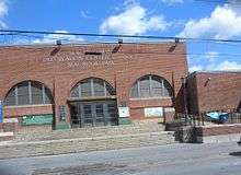
Red Hook is the site of the NYCHA Red Hook Houses, the largest public housing development in Brooklyn, which accommodates roughly 6,000 residents.[15] Red Hook also contains several parks.
IKEA
Red Hook has a large IKEA store (346,000 square feet (32,100 m2)) that opened on June 18, 2008 near the Gowanus Expressway.[16] The building of IKEA was controversial, because it replaced a 19th-century dry dock at 40°40′19.2″N 74°0′47.5″W / 40.672000°N 74.013194°W, which was still in use. Residents cited concerns including traffic congestion, a decrease in property values and destruction of this transit-oriented neighborhood and historically significant buildings in the area.[17]
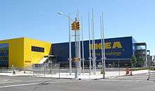
Brooklyn artist Greg Lindquist exhibited a group of paintings in February 2008 in New York City that depicted the IKEA site in process, juxtaposing the maritime decay with the new construction.
A report by the New York City Economic Development Corporation announced the findings and recommendations of its Maritime Support Services Location Study. The study found that New York City needs eight more dry docks. According to the report, it will cost $1 billion to replace the one IKEA is using as a parking lot.[18] No schedule for replacement was announced. In addition, IKEA and its contractor demolished Civil War era buildings and exposed the community to asbestos. IKEA's contractor was found to be in "violation for not having filed asbestos work, failing to monitor the air, not posting any warnings, failure to construct decontamination protections before disturbing the asbestos-containing materials, and doing nothing to protect and decontaminate the material, as well as the workers and building waste."[19]
A once free ferry service for shoppers from Manhattan proved more popular than expected.[20] IKEA charges a fare for the ferry but reimburses the fare at checkout to deter would-be commuters from using the ferry for non-shopping purposes.

Park
A 58.503-acre (236,750 m2) public park is located in southern Red Hook. It contains a paved path, benches, a flagpole with a yardarm, a drinking fountain, handball courts, softball fields, a soccer and football field, a track and field, picnic tables, the adjacent Sol Goldman Pool, and new trees and plantings. The park is maintained and operated by the New York City Department of Parks and Recreation, and is bordered by Otsego, Bay, Hicks, Lorraine, Court, and Halleck Streets.[21]
Transportation
Water
New York City has expanded its water ferry service, operated by New York Water Taxi. This service normally runs between IKEA and Pier 11 in Lower Manhattan, but has added a new stop at Van Brunt Street to support local businesses hurt by Hurricane Sandy. The free ferry runs between 10am and 9pm.[22] Originally, when this free service was first introduced, it proved to be popular with local residents, causing changes in the operating policy to favor IKEA shoppers. Under the current schedule, the ferry runs from Monday to Friday, every 40 minutes from 2pm, $5 for one way. On Saturday and Sunday, it runs free of charge, every 20 minutes from 11am.[23]
In the spring of 2006, the new Carnival Cruise Lines terminal, the Brooklyn Cruise Terminal, opened at Pier 12 at Pioneer Street, bringing additional tourists.
The Red Hook Container Terminal is one of four such facilities in the Port of New York and New Jersey and is the only maritime facility in Brooklyn to handle container ships.[24][25]
The transatlantic liner RMS Queen Mary 2 docks in Red Hook.
Public transport

Subway service in the area is sparse. The closest subway stops are along the IND Culver Line (F G trains), at either Carroll Street or Smith–Ninth Streets stations.
New York City Bus service is also sparse, but popular. The B61 bus route provides service from Hamilton Avenue, through Erie Basin/IKEA Plaza, to Van Brunt St and then northward, through the Columbia Street Waterfront District and terminates in Downtown Brooklyn. It also connects with the Culver Line's Smith–Ninth Streets station. The B57 bus connects Red Hook with Downtown Brooklyn and Maspeth, Queens.
IKEA provides a complimentary shuttle that runs to Smith–Ninth Streets, Fourth Avenue / Ninth Street, and Court Street – Borough Hall subway stations from 3 to 9 p.m. daily, Monday through Friday every half hour, and Saturday and Sunday from 11 a.m. to 9 p.m. every 20 minutes. Non-shoppers also use this service.[23]
Red Hook is expected to be served by the Citywide Ferry Service[26] starting in 2017.[27][28]
Planned streetcars

Though electric trolleys have not run in Brooklyn since 1956,[29] activists led by the Brooklyn Historic Railway Association (BHRA) have been trying to revive streetcars in Red Hook since 1989.[30] With permission from New York City’s government to develop a streetcar line running from Beard Street to Borough Hall, in the 1990s BHRA president Robert Diamond collected disused PCC streetcars that had been used in Boston and Buffalo for potential use on the new line.[29] By 1999, Diamond had begun laying new track for the project, but in 2003 transportation officials elected to revoke Diamond’s rights to the route’s right of way, instead intending to sell them to the highest bidder in the event that the project ever moved forward. Diamond’s efforts to secure independent funding were not successful.[31]
In 2005, Rep. Nydia Velázquez acquired a $300,000 federal grant for a 6-month streetcar study.[30] Though BHRA had estimated $10–$15 million would be required to complete the project, the New York City Department of Transportation (NYCDOT) streetcar feasibility study (completed in April 2011) concluded that the 6.8 mile line would cost $176 million in capital funding, plus an additional $6.2 to $7.2 million in annual operating funds. A significant portion of the capital cost would be required to make modifications to Red Hook’s narrow streets in order to allow streetcars to make right turns.[32]
Despite finding that Red Hook was underserved by transit, the study concluded that due to a number of factors, a streetcar line would not be an appropriate transit solution for the neighborhood. Because 81.5 percent of Red Hook residents did not own a car and therefore were already dependent on transit, the study estimated that a streetcar would generate only 1,822 daily riders. The study also found that a streetcar would not be a significant upgrade over existing buses in terms of travel times and reliability, and would not likely spur significant economic development unless combined with zoning changes from the New York City Department of City Planning (DCP). Since DCP had designated Red Hook as a “working waterfront,” no such zoning changes appeared to be forthcoming.[33]
As of June 2013, Diamond had partnered with John Quadrozzi of Gowanus Bay Terminal (a concrete firm), and the Gowanus Canal Community Development Corporation in an effort to revive the project, which he now envisions running partly underground through a 19th-century Long Island Railroad tunnel. Diamond is pursuing federal funding in order to pay for the project, which he estimates would cost $50 million.[34]
Vehicular
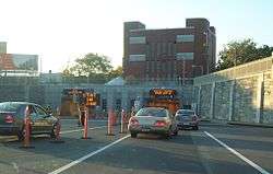
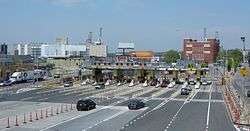
Red Hook is connected to Manhattan by the vehicular Brooklyn-Battery Tunnel, whose toll plaza and approaches separate it from Carroll Gardens and Columbia Street to the north.
The Gowanus Expressway (I-278) also runs through the neighborhood.
Events
- The Red Hook Waterfront Arts Festival[35] is an annual summer kick-off held in Louis J. Valentino, Jr. Park & Pier featuring dance, music, and spoken-word poetry. Dance Theatre Etcetera, the producers of the event, concentrate local resources for residents and bring in community partners with activities for the whole family.
- Sunday's at Sunny's is a reading series held the first Sunday of every month, co-sponsored by Sunny's Bar and the independent bookstore Bookcourt, and co-ordinated by writer Gabriel Cohen. This popular event celebrated its seventh anniversary June 7, 2009.
- Red Hook Crit[36] is an annual, unsanctioned bicycle race held on a springtime night on track bikes. It began as an underground event but has grown to become "what is possibly the country's coolest bike race."[37]
- The Brooklyn Street Circuit is located in Red Hook and will host the New York ePrix.[38]
Notable residents
- Carmelo Anthony (born 1984), basketball player[39]
- Al Capone (1899-1947), gangster[10]
- Joe Gallo (1929-1972), who was commemorated in Bob Dylan's song "Joey" from the album Desire.[40]
- Stephen Kunken (born c. 1971), actor
- H. P. Lovecraft (1890-1937), author[41]
- James McBride, writer[42]
- Norman Mailer, novelist
- Sarah Rapelje, for whose family Brooklyn's Rapelye Street is named[5][43]
- Hell Razah, rapper, member of hip-hop group Sunz of Man
- Matty Rich, director of movies Straight Out of Brooklyn and The Inkwell
- Shabazz the Disciple, rapper, member of hip-hop group Sunz of Man
- Michael Shannon, actor
- Peter Steele (1962-2010), member of Type O Negative
- Taz (whose real name is Peter Senerchia), former professional wrestler and current color commentator
- Eli Wallach (1915-2014), actor[44]
- Michelle Williams, actress
- Dustin Yellin, artist
In popular culture
- Red Hook was the setting for the H. P. Lovecraft 1927 story "The Horror at Red Hook".[45]
- In Thomas Wolfe's short story "Only the Dead Know Brooklyn", the narrator, Wolfe himself, rides the subway at night and is warned by someone he meets to not walk around in Red Hook. It is written in transliterated circa 1936 Brooklynese.
- The 1954 film On the Waterfront is set in Red Hook, though it was filmed in Hoboken, New Jersey.
- The area was used as the setting for Arthur Miller's 1955 play A View from the Bridge.[46]
- Red Hook is the setting for the 1961 book Memos from Purgatory by Harlan Ellison.
- Red Hook is the birthplace of gangster Joe Gallo, which was commemorated in Bob Dylan's song "Joey" from the album Desire.
- In the 1988 film Spike of Bensonhurst, the protagonist moves from Bensonhurst to Red Hook after being chased out of his old neighborhood by the mafia.[47]
- Red Hook was the setting for the 1964 novel Last Exit to Brooklyn by Hubert Selby Jr. and the 1989 film of the same name.[48]
- Red Hook appears in Bill Murray's 1990 movie Quick Change as the neighborhood in which the robbers get lost and witness two men on bikes apparently having some sort of chivalric fight over honor with garden tools.
- The 1991 independent and award-winning film Straight Out of Brooklyn is set in the Red Hook Housing Projects.
- In the 1997 film Cop Land, after a white NYPD officer kills two African American motorists who he thought were firing on him, the other officers back him up referring to his past heroic action in Red Hook.
- Red Hook figures prominently in Gabriel Cohen's 2001 crime novel Red Hook, nominated for the Edgar award for Best First Novel.
- Red Hook is the setting of Reggie Nadelson's 2005 crime novel, also called Red Hook.
- Red Hook is featured in Lil Kim's music video for the song "Lighters Up", which plays homage to Lil Kim's hometown of Brooklyn.
- Pier 41 at 204 Van Dyke Street was used as the setting of a bar scene in the 2005 Will Smith film Hitch.[49]
- A neighborhood based on Red Hook appears in the 2008 video game Grand Theft Auto IV, under the name "East Hook".
- The 2008 independent documentary film A Hole in a Fence by D.W. Young chronicles the changing fortunes of Red Hook.
- In Cassandra Clare's 2009 book City of Ashes', the main characters drive to this beach as a way to get to Valentine's ship.
- The cast of The Real World: Brooklyn, part of MTV's reality television series The Real World, resided at Pier 41 in 2009.[49]
- Red Hook is the first dance battle that takes place in the 2010 film Step Up 3D, in the lead up to the World Jam Competition.
- The protagonist of the 2011 film The Adjustment Bureau grew up in Red Hook.
- It is mentioned in Red Hook Summer, a 2012 American film directed by Spike Lee.
- Red Hook is the setting for "Visitation Street", a 2013 novel by Ivy Pochoda.
- Red Hook is the birthplace and sometimes current residence of Steve Rogers, also known as Captain America.
- Professional wrestler Taz is said to be from the "Red Hook section of Brooklyn, New York".
- "The Red Hook" is the name of a cocktail created at Milk & Honey.[50]
- Red Hook is featured prominently in the FX TV series The Strain.
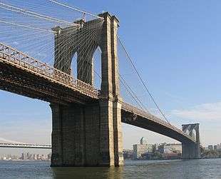
- Red Hook is the setting of the Type O Negative song "In Praise Of Bacchus" off of the album October Rust, as evidenced by the lyric, "The street lamps light a wet old Red Hook road". The song also references the Brooklyn Bridge and Pier 6.
References
- 1 2 3 4 Henry R. Stiles (1869): A History of the City of Brooklyn, Vol. II, available at books.google.com, 500 pages
- ↑ Red Hook History, Waterfront Museum. Accessed September 4, 2016. "The Dutch established the village of Red Hook (Roode Hoek) in 1636. Red Hook was one of the earliest areas in Brooklyn to be settled. The area was named for its red clay soil and the hook shape of its peninsular corner of Brooklyn that projects into the East River."
- ↑ Wick, Steve (March 28, 2009). "14 Generations: New Yorkers Since 1624, the Rapeljes Are On a Mission to Keep Their History Alive". Newsday.
- ↑ Urban Environmentalist: The Hidden History of the Rapaljes, gowanuslounge.com
- 1 2 Benardo, Leonard; Weiss, Jennifer (2006). Brooklyn by Name: How the Neighborhoods, Streets, Parks, Bridges, and More Got Their Names. New York: New York University Press. pp. 59, 60, 69. ISBN 0-8147-9946-9. Retrieved 13 November 2011.
- ↑ Robert B. Roberts (1980): New York's forts in the Revolution, Fairleigh Dickinson University Press, 521 pages
- ↑
- ↑ https://www.nrk.no/video/PS*244112
- ↑ "THE BITTER DESERT | ThelmaxFilm". Thelmax.no. Retrieved 2016-10-04.
- 1 2 "About Red Hook". Red Hook Justice at PBS. Retrieved on November 20, 2008.
- ↑ Rogan, Helen (August 7, 2000). "Red Hook Catches the Wave". New York. Retrieved 2010-09-01.
- ↑ Orchant, Rebecca (November 9, 2012). "Brooklyn's Court Street Grocers On Hurricane Sandy's Aftermath In Red Hook". Huffington Post. Retrieved November 9, 2012.
- ↑ "National Register of Historic Places Listings". Weekly List of Actions Taken on Properties: 10/01/12 through 10/05/12. National Park Service. 2012-10-12.
- ↑ "National Register of Historic Places Listings". Weekly List of Actions Taken on Properties: 6/01/15 through 6/05/15. National Park Service. 2015-06-12.
- ↑ "Redirect". Retrieved 29 September 2014.
- ↑ Carter, Nicole (June 17, 2008). "9 questions for the Brooklyn IKEA store manager". Daily News. New York. Retrieved 2010-09-01.
- ↑ "TEN (10) REASONS TO OPPOSE IKEA-RED HOOK"; bigcityboxes.com; May 2005
- ↑ Calder, Rich (June 23, 2008). "IKEA Berth Pangs; City Dock Deal a $1B Blunder". New York Post. Retrieved 2010-09-01.
- ↑ Wisloski, Jess (January 29, 2005). "IKEA hit with asbestos fines". The Brooklyn Paper. Retrieved 2010-09-01.
- ↑ Calder, Rich (July 17, 2008). "Hook Rocks IKEA Boat". New York Post. Retrieved 2010-09-01.
- ↑ History of Redhook, from the New York City Department of Parks and Recreation
- ↑ "Ferry Tour NYC - New York Water Taxi - Ikea Ferry Shuttle". Retrieved 29 September 2014.
- 1 2 "IKEA Brooklyn: Get directions". Retrieved 29 September 2014.
- ↑ "Press Release Archives #157 CITY PURCHASES NEW CONTAINER CRANES FOR BROOKLYN'S RED HOOK CONTAINER TERMINAL". Retrieved 29 September 2014.
- ↑ http://www.asiterminals.com/
- ↑ DNAinfoNewYork. "Proposed Routes for NYC's Expanded Ferry Service". Scribd. Retrieved September 22, 2016.
- ↑ "Citywide Ferry Service to Launch in June 2017, Official Says". DNAinfo New York. 2016-03-03. Retrieved 2016-09-22.
- ↑ "New York City's Ferry Service Set to Launch in 2017". NBC New York. Retrieved 9 May 2016.
- 1 2 "De Blasio gives Diamond hope for Red Hook trolley plan". Retrieved 29 September 2014.
- 1 2 Calder, Rich. "Trolley good news for Red Hook rail plan". New York Post.
- ↑ "RED HOOK TROLLEY REVIVAL - Forgotten New York". Forgotten-ny.com. 2012-03-13. Retrieved 2016-10-04.
- ↑ http://www.nyc.gov/html/dot/downloads/pdf/201108_redhook_sc_final_report.pdf
- ↑ http://www.nyc.gov/html/dot/downloads/pdf/201108_redhook_sc_final_report.pdf
- ↑ "Train buff's dreams streetcar desire will become reality". The Brooklyn Paper. Retrieved 29 September 2014.
- ↑ Red Hook Waterfront Arts Festival
- ↑ Red Hook Crit
- ↑ Landau, Ian. "At the Red Hook Crit, It's Anyone's Race". Bicycling Magazine. Retrieved 3 September 2011.
- ↑ http://www.nytimes.com/2016/09/22/sports/autoracing/formula-e-racing-brooklyn-new-york.html?_r=0
- ↑ Taylor, Nate. "Excited for Return to Brooklyn, Anthony Gets the Ending Wrong", The New York Times, November 26, 2012. Accessed September 4, 2016. "On Monday, two miles from where he grew up in the apartments known as the Red Hook Houses, Anthony was on the floor of the new Barclays Center, still dribbling, and scoring, as he tried to lead the Knicks over the Nets in the official christening of their New York-Brooklyn rivalry."
- ↑ McShane, Larry. "Tribute for dead mobster, Crazy Joe Gallo", New York Daily News, March 31, 2012. Accessed September 4, 2016. "Bob Dylan immortalized Gallo in his 1975 song 'Joey,' offering a version of the Umberto killing where the doomed mobster 'pushed the table over to protect his family/Then he staggered out into the streets of Little Italy.' Nash says Gallo's reputation as the Robin Hood of Red Hook isn't quite accurate."
- ↑ "Howard Phillips Lovecraft: The Life of a Gentleman of Providence". Hplovecraft.com. Retrieved 2016-10-04.
- ↑ Weichselbaum, Simone (13 August 2012). "'Red Hook Summer' writer James McBride wants America 'shaken awake' to life in public housing". "Daily News". Retrieved 29 September 2015.
- ↑ The New American Cyclopedia, George Ripley, D. Appleton & Co., New York, 1858
- ↑ Berkvist, Robert. "Eli Wallach, Multifaceted Actor on Stage and Screen, Dies at 98", The New York Times, June 25, 2014. Accessed September 4, 2016. "Eli Wallach was born in Red Hook, Brooklyn, on Dec. 7, 1915, the son of Abraham Wallach, who owned a candy store in the neighborhood, and the former Bertha Schorr."
- ↑ Emrys, Ruthanna; and Pillsworth, Anne M. "Lovecraft’s Most Bigoted Story, No Really: 'The Horror at Red Hook'", Tor.com, March 3, 2015. Accessed September 4, 2016. "Dublin-born Thomas Malone is a writer playing at detective work in New York when a nasty case in the Brooklyn neighborhood of Red Hook earns him a rest cure in bucolic Pascoag, Rhode Island."
- ↑ Staff. "On This Day in History, February 10: Death of a Playwright", Brooklyn Daily Eagle. Accessed September 4, 2016. "Miller’s experience in Red Hook gave him the background for A View From the Bridge and the young lawyer furnished part of the characterization of Alfieri."
- ↑ Yagoda, Ben. "Shades Of Moonstruck", The Philadelphia Inquirer, December 9, 1988. Accessed September 4, 2016. "Spike gets involved with the beleaguered local mob boss (a very appealing performance by Ernest Borgnine), gets the big guy's daughter (Maria Patillo) pregnant, gets banished from his home neighborhood of Bensonhurst, moves in with a Puerto Rican family in Red Hook, throws all the drug pushers out of that neighborhood, gets let back in his own neighborhood, messes up again, finally wins a fight, then suffers a final reversal."
- ↑ DePalma, Anthony. "Hubert Selby Jr. Dies at 75; Wrote Last Exit to Brooklyn", The New York Times, April 27, 2004. Accessed September 4, 2016. "And when Last Exit, which consists of 'Tralala' and five other loosely connected stories, was published in England in 1966, a jury found it to be obscene and fined its publisher. The novel describes the seedy underbelly of the Red Hook waterfront neighborhood in the Brooklyn of the 1950's, which is depicted as a wasteland prowled by gangs, whores and transvestites."
- 1 2 Martin, Michael "Real World Brooklyn Docks at Pier 41 in Red Hook", mm-agency.com; July 21, 2008]
- ↑ Roddy Rickhouse; "Frontier Mixology: Bar Review & Cocktail Two-fer, Red Hook’s Fort Defiance"; frontpsych.com; May 20, 2011
External links
| Wikimedia Commons has media related to Red Hook, Brooklyn. |
-
 Gowanus and Red Hook travel guide from Wikivoyage
 - Red Hook Star-Revue local newspaper distributed in Red Hook and the adjacent Columbia Waterfront District and Carroll Gardens.