Sturgeon River (Alberta)
| Sturgeon River | |
|---|---|
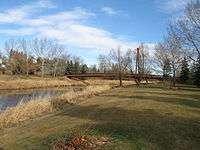
 Sturgeon River in St. Albert | |
| Country | Canada |
| Basin | |
| Main source |
Hoople Lake, Alberta 840 m (2,760 ft) |
| River mouth |
North Saskatchewan River 600 m (2,000 ft) 53°46′05″N 113°10′15″W / 53.76806°N 113.17083°WCoordinates: 53°46′05″N 113°10′15″W / 53.76806°N 113.17083°W |
| Physical characteristics | |
| Length | 260 km (160 mi) |
| Discharge |
|
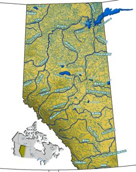
The Sturgeon River is a 260 km long river located in central Alberta, Canada. It is a major tributary of the North Saskatchewan River. The stream crosses Sturgeon County, which was named for this river.
At the Villeneuve station, Sturgeon River has a discharge of 0.4 to 3 m³/s.[1]
Fish species which may be found in the river include: walleye, pike, perch, burbot, goldeye, sturgeon, whitefish, and sauger.
Course
The Sturgeon River originates about 90km west of Edmonton just west of Isle Lake. It flows east toward Edmonton and about 15 km northwest of Edmonton (near St. Albert) turns northeast. About 38 km north-northeast of Edmonton (near Gibbons) it turns to the southeast. It enters the North Saskatchewan River at a point about 35 km northeast of Edmonton and about 8 km northeast of Fort Saskatchewan.
Tributaries
- Riviere Qui Barre
- Atim Creek
- Little Egg Creek
Numerous lakes are found in the upper watershed, including Isle Lake, Lac Ste. Anne, Birch Lake, Sandy Lake, Deadman Lake, Matchayaw Lake, Gladu Lake, Atim Lake and Big Lake.
See also
References
- ↑ Sturgeon River near Villeneuve from Alberta Environment River Basins in Alberta