Stowey

Coordinates: 51°20′05″N 2°34′46″W / 51.3346°N 2.5794°W
Stowey is a small village within the Chew Valley in Somerset, England. It lies south of Chew Valley Lake and north of the Mendip Hills, approximately 10 miles (16 km) south of Bristol on the A368 road Weston-super-Mare to Bath. Stowey and its neighbouring and larger village, Bishop Sutton, form the civil parish of Stowey Sutton.
History
There is some evidence of a possible wooden enclosure from the Iron Age known as Stowey Castle.[1][2] There is also some evidence of an ochre crushing mill used for making pigment for marking sheep.[3]
The parish was part of the hundred of Chew.[4]
The early Lords of the Manor were the FitzRichard family. In the early 17th century it was held by the Jones family, who held it until 1840 when it was sold to Sir Edward Strachey.[5]
Government
Stowey and Bishop Sutton make up the Stowey Sutton Parish Council, which has some responsibility for local issues, and is part of the Chew Valley South Ward, which is represented by one councillor on the Bath and North East Somerset Unitary Authority which has wider responsibilities for services such as education, refuse, tourism etc. The village is a part of the North East Somerset constituency and part of the South West England constituency of the European Parliament.
Geography
Along with the rest of South West England, Stowey has a temperate climate which is generally wetter and milder than the rest of England. The annual mean temperature is about 10 °C (50 °F) with seasonal and diurnal variations, but due to the modifying effect of the sea, the range is less than in most other parts of the United Kingdom. January is the coldest month with mean minimum temperatures between 1 and 2 °C (34 and 36 °F). July and August are the warmest months in the region with mean daily maxima around 21 °C (70 °F). In general, December is the dullest month and June the sunniest. The south west of England enjoys a favoured location, particularly in summer, when the Azores High extends its influence north-eastwards towards the UK.[6]
Cloud often forms inland, especially near hills, and reduces exposure to sunshine. The average annual sunshine totals around 1600 hours. Rainfall tends to be associated with Atlantic depressions or with convection. In summer, convection caused by solar surface heating sometimes forms shower clouds and a large proportion of the annual precipitation falls from showers and thunderstorms at this time of year. Average rainfall is around 800–900 mm (31–35 in). About 8–15 days of snowfall is typical. November to March have the highest mean wind speeds, with June to August having the lightest. The predominant wind direction is from the south west.[6]
There are several sites of Nature Conservation Interest and Special Scientific Interest in and around the village.
Folly Farm
Near to the village is Folly Farm, a 17th-century farm with traditionally managed, unimproved, neutral grassland, flowery meadows and woodlands with splendid views, run by Avon Wildlife Trust. Folly Farm includes two SSSIs — the meadows (19.36 hectares) and Dowlings Wood (9 hectares).[7]
Demographics
According to the 2001 Census, the Chew Valley South Ward (which includes Bishop Sutton and Stowey), had 1,222 residents, living in 476 households, with an average age of 40.3 years. Of these 76% of residents describing their health as 'good', 25% of 16- to 74-year-olds had no qualifications; and the area had an unemployment rate of 1.9% of all economically active people aged 16–74. In the Index of Multiple Deprivation 2004, it was ranked at 28,854 out of 32,482 wards in England, where 1 was the most deprived LSOA and 32,482 the least deprived.[8]
Landmarks
Sutton Court
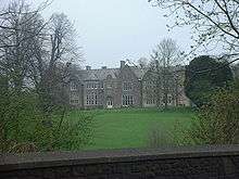
Sutton Court, also known as Stowey Court, is a large house built on the site of a 14th-century castle, with sections built in the 15th and 16th century. About 1558 (former date on a fireplace) Bess of Hardwick and her second husband, Sir William St. Loe, added a north-east wing with a parlour and chapel, which includes Tudor buttresses.[9] The house was then left to her son Charles Cavendish, but later the property passed to the Strachey family.[3] From about 1650–1700 it was the seat of Richard Jones and his son Sir William Jones, the Attorney General of England.[10] Around 1800 it was the seat of the Strachey family including Richard Strachey and his brother John Strachey. Much of the house was remodelled in 1858 by Thomas Henry Wyatt.[9] Life at Sutton Court was described by John St. Loe Strachey in his autobiographical book The Adventure of Living in 1922.[11] It is a Grade II* listed building.[12] A curtain wall to the north of Sutton Court with a gazebo is also listed.[13] The Lodge is also Grade II listed.[14]
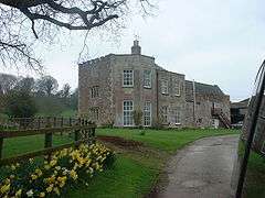
Stowey House
Another significant building in the village is Stowey House to the north-west of the church, which includes original 17th-century gables, but was considerably extended in Georgian times.[3] It is a Grade II listed building.[15]
Church
The Church of St Nicholas and St Mary is a Church of England parish church, which dates back to the 15th century, when it was a chapelry of Chew Magna,[5] includes wall paintings by Henry Strachey from 1915.[9] It is a Grade II listed building.[16]
"Stowey" is the name of a hymn tune which was adapted by Ralph Vaughan Williams for "When a Knight Won His Spurs."
References
- ↑ "Stowey Castle, Stowey Sutton". Gatehouse gazetteer of the medieval fortifications and castles of England and Wales. Retrieved 25 April 2006.
- ↑ "Area 2 Chew Valley". Rural Landscapes. Bath and North East Somerset Council. Retrieved 1 January 2011.
- 1 2 3 Mason, Edmund J. & Mason, Doreen (1982). Avon Villages. Robert Hale Ltd. ISBN 0-7091-9585-0.
- ↑ "Somerset Hundreds". GENUKI. Retrieved 8 October 2011.
- 1 2 Robinson, W.J. (1915). West Country Churches. Bristol: Bristol Times and Mirror Ltd. pp. 206–210.
- 1 2 "South West England: climate". Met Office. Retrieved 14 March 2010.
- ↑ "Folly Farm SSSI". Natural England. Retrieved 1 January 2011.
- ↑ "Neighbourhood Statistics LSOA Bath and North East Somerset 021C Chew Valley South". Office for National Statistics 2001 Census. Retrieved 25 April 2006.
- 1 2 3 Pevsner, Nikolaus (2000). The Buildings of England: North Somerset and Bristol. Penguin Books. ISBN 0-14-071013-2.
- ↑ Cruickshanks (1986). The House of Commons 1690–1715 5-Volume Set p. 527. Cambridge University Press. ISBN 0-521-77221-4.
- ↑ St. Loe Strachey, John (1922). The Adventure of Living A Subjective Autobiography (1860–1922). ISBN 1-4043-5656-8. Retrieved 21 May 2006.
- ↑ "Sutton Court". Images of England. Retrieved 9 May 2006.
- ↑ "Curtain wall to north of Sutton Court with gazebo". Images of England. Retrieved 9 May 2006.
- ↑ "Sutton Court Lodge". Images of England. Retrieved 9 May 2006.
- ↑ "Stowey House". Images of England. Retrieved 9 May 2006.
- ↑ "Church of St Nicholas and St Mary". Images of England. Retrieved 9 May 2006.
External links
![]() Media related to Stowey at Wikimedia Commons
Media related to Stowey at Wikimedia Commons