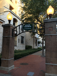
State Thomas, Dallas
| State Thomas Historic District | |
|---|---|
 | |
| Location | Dallas, Texas |
| Coordinates | 32°47′42″N 96°48′0″W / 32.79500°N 96.80000°WCoordinates: 32°47′42″N 96°48′0″W / 32.79500°N 96.80000°W |
| Architectural style(s) | Italianate, Queen Anne and Vernacular styles[1] |
 Location of State Thomas Historic District in Texas | |
State Thomas is a Dallas Landmark District in the Uptown area of Dallas, Texas (USA). It borders downtown to the south at Woodall Rodgers Freeway, Bryan Place to the east at US 75 (Central Expressway), and LoMac to the north and west.
The State Thomas neighborhood contains the largest collection of Victorian-era homes remaining in Dallas.[1] The establishment of the region as a Special Purpose District in 1986 helped make it one of the first new urbanist regions in the city.
Griggs Park
Griggs Park sits on the northeastern edge of State Thomas, where the neighborhood borders Woodall Rodgers Freeway. The pet-friendly park spans 8 acres and features walking paths, benches, groves of trees, and views of both the downtown and uptown Dallas skylines.[2] The park also features a memorial to the park's namesake, the Rev. A.R. Griggs, a 19th Century Baptist preacher and leader in the historic State Thomas and Freedman’s community.[3]
Gallery
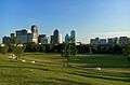 Downtown Dallas skyline as viewed from Griggs Park
References
- 1 2 "City of Dallas, Texas - Landmark Districts". Dallascityhall.com. Retrieved 2011-03-16.
- ↑ http://www.uptowndallas.net/get-involved/griggs-park
- ↑ https://tshaonline.org/handbook/online/articles/fgrax