Stacks Bluff
| Stacks Bluff | |
|---|---|
|
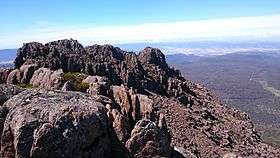
Stacks Bluff from summit cairn | |
| Highest point | |
| Elevation | 1,527 m (5,010 ft) [1][2] |
| Isolation | 10.41 km (6.47 mi) [2] |
| Listing | 9th highest mountain in Tasmania[2] |
| Coordinates | 41°37′12″S 147°40′48″E / 41.62000°S 147.68000°ECoordinates: 41°37′12″S 147°40′48″E / 41.62000°S 147.68000°E [3] |
| Geography | |
 Stacks Bluff Location in Tasmania | |
| Location | Northeast Tasmania, Australia |
| Parent range | Ben Lomond |
| Geology | |
| Age of rock | Jurassic |
| Climbing | |
| First ascent |
Plangermaireener (circa?); Aboriginal
John Batman (1820s); European |
The Stacks Bluff is a peak in northeast Tasmania, Australia. The mountain is situated on the Ben Lomond plateau.
At 1,527 metres (5,010 ft) above sea level, it is the ninth highest mountain in Tasmania,[2] and is a feature visible throughout the Tasmanian Midlands - prominent due to its extensive promontory cliff-line and exposed dolerite columns.
Aboriginal History of Stacks Bluff
The mountain was originally occupied by Tasmanian Aboriginal people of the Ben Lomond Nation, who habituated the plateau in summer and left evidence of campsites and artifacts at Lake Youl (Palawa: meenemata) 2-kilometre (1.2 mi) north of the summit block of Stacks Bluff.[4][4][5] The clans of the Ben Lomond Nation who occupied this area were the Plangermaireener and Plindermairhemener, who regularly traversed the river valleys and marshes below Stacks Bluff.
The aboriginal names for Stacks Bluff and surrounds are uncertain but modern etymological research has determined this toponymy:
- parndokeenne (parn.doke.en.ne) - Stacks Bluff, subsequently adapted for the clan country north of Campbell Town - literally 'the lands under Stacks Bluff'
- loonder - contraction of name for the South Esk Valley under the peak - likely to translate as 'plains'
- tritterrer (trit.ter.rer)- alternate name for the peak - ter translates as 'bluff'
- troune - name for 'Ben Lomond country' ; literally 'long grass'[6] -
- tudema tura - name recorded by John Glover for Ben Lomond southern massif
- meenamata - mena/miena = lake or lagoon - probably referring to Lake Youl - the plateau's largest water feature, with evidence of artefact deposits
- kullewareper (kul.le.ware.per) - the Ben Lomond Rivulet, under Stacks Bluff[7][8]
Both the ethnographic record and archeological evidence describes their habitation and visitation of the country surrounding the peak.[4][8] John Batman, whilst prosecuting his commission to round up the Ben Lomond clans in a 'roving party', wrote in his diary in 1830:
"Made round to the stacks of the mountain (i.e. Stacks Bluff), and stopped on a spot where the women said would be the most likely the Blacks would come or pass, that it was the usual beat for them" [9]
Modern European history
John Batman was likely to have been the first European to have visited the area, as he records crossing the plateau to his farm on the Ben Lomond Rivulet in the 1820s. The artist John Glover ascended the plateau in January 1833 and sketched the northern aspect of Stacks Bluff, as well as the prominent features around the peak.[10]
The name Ben Lomond originally pertained to the southern end of the plateau and the southern extremity was originally named 'the Butts' by European settlers and then, colloquially, as 'the Stacks' - on account of the rock formations on the southern aspect of the bluff.[11] The toponym 'Stacks Bluff' first appears on maps in 1915.[12]
The 'uppermost peak' of the Bluff (the first prominent isolated eminence) was hitherto known locally as Ernest Crag (or Craig), although this name no longer appears on modern maps.[13]
In 1841 the plateau was surveyed by the Polish Explorer Strzelecki who incorrectly calculated barometrically the summit of the plateau as being Stacks Bluff at 5,002 feet (1,525 m).[14] After a further survey by James Sprent, the peak had a trigonometric survey point and an elaborate summit cairn constructed by convict workers in 1852. The trig station was '89 feet high' and constructed from timber carried up by manual labour from the valley below.[15]The trigonometric station was called The Stockade by locals, on account of the palisade surrounding the central cairn, but by the turn of the 20th century it had largely disappeared.[16]
A full survey of Ben Lomond was conducted from September 1905 to 1912 by Colonel William Vincent Legge, Stacks Bluff was found to be the second highest feature on the plateau at this time.[14]
Hiking
Stacks Bluff was a popular destination for walkers from at least the 1830s with the original track leading from Avoca via the Ben Lomond Marshes and the headwaters of the Ben Lomond Rivulet.[14] Mining became established in the foothills of Stacks Bluff from the late 1800s to the 1950s. Tin and tungsten were the principal minerals to be obtained here and the townships of Rossarden and Storys Creek arose to support this commercial activity. Coal was found at Buffalo Brook, about half way between Stacks Bluff and Avoca, whereupon the Stanhope Mine was established. Walking excursions to the plateau, and mining activity, became popular enough in the late 1880s for a landowner to build a two-storey hotel with a store, bakehouse and stables at the northern end of the Ben Lomond Marshes - under the western face of Stacks Bluff.[17] This was the 'Ben Lomond Hotel', built by J.F. Rigney of "Bona Vista", near Fingal - but by 1908 the hotel had been abandoned and fallen into disrepair.[14][18][19]
Stacks Bluff is a major feature of the national park, and is a popular venue with bushwalkers and mountain climbers.[20] A walking track exists from Storys Creek to the summit and the peak may also be accessed from the ski-fields across the trackless, although open, plateau.[21][22]
See also
References
- ↑ "LISTmap (Stacks Bluff)". Tasmanian Government Department of Primary Industries and Water. Retrieved 25 March 2008.
- 1 2 3 4 "Stacks Bluff, Australia". Peakbagger.com. Retrieved 7 June 2015.
- ↑ "Stacks Bluff (TAS)". Gazetteer of Australia online. Geoscience Australia, Australian Government.
- 1 2 3 Kee, Sue (1991). Aboriginal archaeological sites in North East Tasmania. Hobart: Occasional paper / Dept. of Parks, Wildlife and Heritage 0156-2797 ; no. 28. ISBN 0724617620.
- ↑ Ryan, Lyndall (2012). Tasmanian Aborigines : a history since 1803 (1 ed.). Crows Nest: Allen & Unwin. ISBN 9781742370682.
- ↑ Taylor, John (2006). "The Palawa (Tasmanian Aboriginal) Languages: A Preliminary Discussion". UTAS Thesis.
- ↑ Taylor, John (1996). "Dictionary of Palawa place names". State Library of Tasmania/Riuwanna - UTAS: 72.
- 1 2 Plomley, Brian (1992). Tasmanian aboriginal place names. Launceston: Queen Victoria Museum & Art Gallery.
- ↑ Kee, Sue (July 1991). Aboriginal Archeological Sites in North East Tasmania. Hobart, Tasmania: Commonwealth of Australia Department of Parks, Wildlife and Heritage. p. 101.
- ↑ Hansen, David (2003). John Glover The Van Diemen's land sketchbook. Tasmanian Museum and Art Gallery. Hobart. ISBN 09750545-3-8.
- ↑ "The Courier, Hobart Tas". 21 Jul 1843. Retrieved 6 July 2015.
- ↑ "Stephen Spurling" (PDF). University of Tasmania.
- ↑ Marc., Hal (22 May 1897). [Trove.nla.gov.au "Ben Lomond"] Check
|url=value (help). The Examiner. Retrieved 21 October 2015. - 1 2 3 4 Plomley, Brian (1988). "1988 ELDERSHAW MEMORIAL LECTURE BEN LOMOND: HISTORY AND SCIENCE".
- ↑ "Perigrinations: Notes of a Trip to Ben Lomond". Tasmanian News. 15 March 1886. Retrieved 1 April 2015.
- ↑ "Unknown" (PDF). University of Tasmania. Retrieved 19 August 2016.
- ↑ "BEN LOMOND WITHOUT ITS MINES". The Mercury. National library of Australia. 7 June 1888. Retrieved 8 December 2014.
- ↑ Wandering Willie (sic) (18 October 1909). "BEN LOMOND: A MICHAELMAS TRIP". Daily Telegraph (Launceston). Retrieved 8 December 2014.
- ↑ Daily Telegraph. Launceston, Tasmania. 18 October 1909. p. 3. Missing or empty
|title=(help); - ↑ "Ben Lomond Southern Escarpment". Thesarvo. Retrieved 30 March 2015.
- ↑ Wilkinson, Bill (1994). The Abels : a comprehensive guide to Tasmania's mountains over 1100m high. Launceston: Tasmanian Outdoors Collection,. ISBN 0646 216910.
- ↑ Ben Lomond plateau ski and walk (Map). Hobart: Tasmap; Government of Tasmania. 1988.