Du Cane Range
| Du Cane | |
|---|---|
|
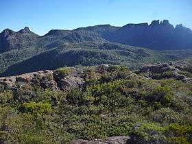
Peaks of the Du Cane Range from the Labyrinth region, 2014 | |
| Highest point | |
| Peak | unnamed peak |
| Elevation | 1,520 m (4,990 ft) |
| Geography | |
 Location in Tasmania | |
| Country | Australia |
| State | Tasmania |
| Range coordinates | 41°56′S 146°02′E / 41.94°S 146.04°ECoordinates: 41°56′S 146°02′E / 41.94°S 146.04°E [1] |
| Geology | |
| Age of rock | Jurassic |
| Type of rock | Dolomite |
The Du Cane Range is a mountain range in the Central Highlands region of Tasmania, Australia.
An unnamed peak on the main ridge of the Du Cane Range has an elevation of 1,520 metres (4,990 ft) above sea level and is the eleventh highest mountain peak in Tasmania. Major peaks in the range include The Acropolis, Mount Geryon, The Parthenon, Mount Eros, Mount Hyperion, Mount Massif and Falling Mountain. Tasmania's highest peak at an elevation of 1,617 metres (5,305 ft) is nearby, but not in the Du Cane Range.[2]
The range is a major feature of the Cradle Mountain-Lake St Clair National Park, and is a popular venue with bushwalkers and mountain climbers.
The Du Cane Range was named in honour of Sir Charles Du Cane, KCMG, the Governor of Tasmania from 1874 to 1878.[3]
See also
References
- ↑ "Du Cane Range (TAS)". Gazetteer of Australia online. Geoscience Australia, Australian Government.
- ↑ "Map of Du Cane Range, TAS". Bonzle Digital Atlas of Australia. Retrieved 7 June 2015.
- ↑ Rimmer, Gordon (1972). "Du Cane, Sir Charles (1825–1889)". Australian Dictionary of Biography. 4. Canberra: Australian National University. Retrieved 5 June 2015.
External links
- Parks Tasmania
- Kiernan , Kevin (1992). "Mountain geomorphology and the Last Glaciation at Lake St Clair" (PDF). Papers and Proceedings of the Royal Society of Tasmania. Department of Geography and Environmental Studies, University of Tasmania. 126: 47–57. OCLC 271191704. Retrieved 7 June 2015.