Spooner Summit
| Spooner Summit | |
|---|---|
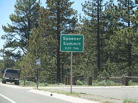 | |
| Elevation | 7,146 ft (2,178 m) |
| Traversed by |
|
| Location | Douglas County, Nevada |
| Range | Carson Range |
| Coordinates | 39°06′15″N 119°53′50″W / 39.104233°N 119.897158°WCoordinates: 39°06′15″N 119°53′50″W / 39.104233°N 119.897158°W |
Spooner Summit is a mountain pass through the Carson Range, linking the Lake Tahoe Area to Carson City via US 50.[1] The highest point of the pass is located just east of Spooner Lake just before the first set of curves when traveling eastbound.
The pass also carried the Lincoln Highway over the Carson Range along its Sierra Nevada Southern Route before being renumbered as US 50 and rerouted near Johnson Pass.[2]
The Tahoe Rim Trail is accessible from a small parking lot at the summit.[3][4]
References
This article is issued from Wikipedia - version of the 2/9/2016. The text is available under the Creative Commons Attribution/Share Alike but additional terms may apply for the media files.