Spanish Fort, Texas
|
Spanish Fort Site | |
 | |
 Spanish Fort Location of Spanish Fort in Texas | |
| Location | Montague County, Texas |
|---|---|
| Nearest city | Nocona, Texas |
| Coordinates | 33°57′7.2318″N 97°37′36.0948″W / 33.952008833°N 97.626693000°WCoordinates: 33°57′7.2318″N 97°37′36.0948″W / 33.952008833°N 97.626693000°W |
| Area | 100 acres (40 ha) |
| Built | 1759 |
| NRHP Reference # | 75002000 |
| # | 369976 |
| Significant dates | |
| Significant Event | 1759 |
| Added to NRHP | April 14, 1975 |
| Designated | April 14, 1975 |
Spanish Fort is an unincorporated community in north central Montague County, Texas, United States at the end of Farm Road 103 one mile south of the Red River.[1]
History
Native Americans long used the fertile areas near the Red River for farming and hunting. Taovoyas, flying the French flag, established a fort here around 1750 to defend against Spanish incursions in the area. In 1759, in the Battle of the Twin Villages, a Spanish army under Col. Diego Ortiz Parrilla attacked the Taovoyas' fortified position, but were defeated by a force of both the Taovoyas and Comanche tribes. Anglo settlers later misnamed the area Spanish Fort after assuming that the Spanish forces had built a fortification there, rather than the Native Americans.
By 1859, Anglos began settling the area as the population of Native Americans dwindled. White settlement was encouraged across the newly formed Republic of Texas, and though Texas became a state in 1845, European settlers kept coming to Texas for farm land. By the early 1870s, a town called Burlington had been established near present-day Spanish Fort. The town was strategically located along the Chisholm Trail, and it became a popular cowboy town on the cattle drives from south and central Texas to Kansas. Nearby Red River Station, Texas, was the last stop before entering Indian Territory and virtually all cattle driven along the Chisolm Trail crossed at Red River Station. The town grew and citizens applied for a post office in 1876, but were rejected based on another Texas town of the same name. Two local men suggested the misnomer "Spanish Fort" after the ruins nearby. The new name was accepted, and the Spanish Fort post office opened in 1877.
At its peak, the town had numerous businesses and churches, a Masonic lodge, five physicians, four hotels, and several saloons. Spanish Fort became known as a very rough and tumble cowboy town, and at least 40 murders are said to have occurred during the cattle drive heyday.
Herman Joseph Justin founded the boot company which later grew into Justin Industries. Justin took orders from the drivers going north and had their custom-made boots ready in time for them to pick up on their way back through.
But Spanish Fort would suffer, as many small Texas towns did, by being bypassed by the railroad. When fencing and railroads put an end to the cattle drives, small towns not directly served by railways faltered.
The 20th century saw Spanish Fort almost completely vanish. The post office, school, and newspapers all had closed by 1970. Even the oil boom in Nocona's North Field could not save Spanish Fort, and the town has maintained a population of around 50 ever since.
Education
Spanish Fort is serviced by the Prairie Valley Independent School District.
Historical record
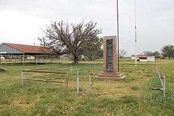
Spanish Fort received historic markers in 1936 and 1976 recognizing the Taovayo tribe culture and the 1759 confrontation with a Spanish expedition.[2][3][4]
The Spanish Fort site was added to the National Register of Historic Places in 1975.[5]
References
- ↑ Morrell, Lea Anne. "Spanish Fort, Texas". TSHA Handbook of Texas Online. Retrieved October 20, 2013.
- ↑ "Spanish Fort - Marker Number:5000". Texas Historic Sites Atlas. Texas Historical Commission. 1936.
- ↑ "Site of the 1759 Taovayo Victory Over Spain - Marker Number:4922". Texas Historic Sites Atlas. Texas Historical Commission. 1976.
- ↑ http://www.9key.com/markers/marker_detail.asp?atlas_number=5337004922
- ↑ "Spanish Fort Site - NRHP Reference:75002000". Texas Historic Sites Atlas. Texas Historical Commission. April 14, 1975.
Municipalities and communities of Montague County, Texas, United States | ||
|---|---|---|
| Cities | 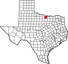 | |
| CDPs | ||
| Other unincorporated communities | ||
| Ghost town | ||