South Haven, Kansas
| South Haven, Kansas | |
|---|---|
| City | |
 Location within Sumner County and Kansas | |
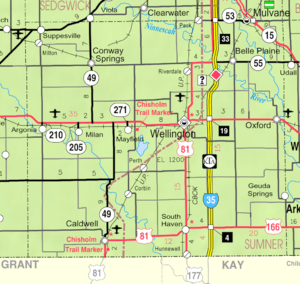 KDOT map of Sumner County (legend) | |
| Coordinates: 37°3′1″N 97°24′7″W / 37.05028°N 97.40194°WCoordinates: 37°3′1″N 97°24′7″W / 37.05028°N 97.40194°W | |
| Country | United States |
| State | Kansas |
| County | Sumner |
| Area[1] | |
| • Total | 0.79 sq mi (2.05 km2) |
| • Land | 0.79 sq mi (2.05 km2) |
| • Water | 0 sq mi (0 km2) |
| Elevation | 1,122 ft (342 m) |
| Population (2010)[2] | |
| • Total | 363 |
| • Estimate (2015)[3] | 350 |
| • Density | 460/sq mi (180/km2) |
| Time zone | Central (CST) (UTC-6) |
| • Summer (DST) | CDT (UTC-5) |
| ZIP code | 67140 |
| Area code | 620 |
| FIPS code | 20-66650 [4] |
| GNIS feature ID | 0470073 [5] |
| Website | City Website |
South Haven is a city in Sumner County, Kansas, United States. As of the 2010 census, the city population was 363.[6]
History
South Haven was founded in 1872,[7] and was named after South Haven, Michigan.[8] The railroad reached South Haven in 1879.[7]
Geography
South Haven is located at 37°3′1″N 97°24′7″W / 37.05028°N 97.40194°W (37.050187, -97.401997).[9] According to the United States Census Bureau, the city has a total area of 0.79 square miles (2.05 km2), all of it land.[1]
Demographics
| Historical population | |||
|---|---|---|---|
| Census | Pop. | %± | |
| 1880 | 124 | — | |
| 1890 | 465 | 275.0% | |
| 1900 | 411 | −11.6% | |
| 1910 | 483 | 17.5% | |
| 1920 | 423 | −12.4% | |
| 1930 | 442 | 4.5% | |
| 1940 | 405 | −8.4% | |
| 1950 | 358 | −11.6% | |
| 1960 | 408 | 14.0% | |
| 1970 | 413 | 1.2% | |
| 1980 | 439 | 6.3% | |
| 1990 | 420 | −4.3% | |
| 2000 | 390 | −7.1% | |
| 2010 | 363 | −6.9% | |
| Est. 2015 | 350 | [3] | −3.6% |
| U.S. Decennial Census | |||
2010 census
As of the census[2] of 2010, there were 363 people, 142 households, and 97 families residing in the city. The population density was 459.5 inhabitants per square mile (177.4/km2). There were 172 housing units at an average density of 217.7 per square mile (84.1/km2). The racial makeup of the city was 94.2% White, 0.3% African American, 1.7% Native American, 0.3% Asian, 1.9% from other races, and 1.7% from two or more races. Hispanic or Latino of any race were 7.4% of the population.
There were 142 households of which 37.3% had children under the age of 18 living with them, 52.1% were married couples living together, 9.9% had a female householder with no husband present, 6.3% had a male householder with no wife present, and 31.7% were non-families. 29.6% of all households were made up of individuals and 12.7% had someone living alone who was 65 years of age or older. The average household size was 2.56 and the average family size was 3.20.
The median age in the city was 37.3 years. 30.3% of residents were under the age of 18; 6% were between the ages of 18 and 24; 26.2% were from 25 to 44; 24.6% were from 45 to 64; and 12.9% were 65 years of age or older. The gender makeup of the city was 50.4% male and 49.6% female.
2000 census
As of the census[4] of 2000, there were 390 people, 163 households, and 99 families residing in the city. The population density was 477.4 people per square mile (183.6/km²). There were 182 housing units at an average density of 222.8 per square mile (85.7/km²). The racial makeup of the city was 94.10% White, 1.79% Native American, 1.79% from other races, and 2.31% from two or more races. Hispanic or Latino of any race were 3.33% of the population.
There were 163 households out of which 30.1% had children under the age of 18 living with them, 51.5% were married couples living together, 7.4% had a female householder with no husband present, and 38.7% were non-families. 36.8% of all households were made up of individuals and 15.3% had someone living alone who was 65 years of age or older. The average household size was 2.39 and the average family size was 3.19.
In the city the population was spread out with 29.5% under the age of 18, 5.1% from 18 to 24, 26.2% from 25 to 44, 22.6% from 45 to 64, and 16.7% who were 65 years of age or older. The median age was 37 years. For every 100 females there were 97.0 males. For every 100 females age 18 and over, there were 91.0 males.
The median income for a household in the city was $31,932, and the median income for a family was $37,917. Males had a median income of $26,111 versus $24,375 for females. The per capita income for the city was $14,019. About 8.3% of families and 9.9% of the population were below the poverty line, including 15.6% of those under age 18 and 14.5% of those age 65 or over.
Notable people
- Forest Geyer, American football player. He was elected to the College Football Hall of Fame in 1973.
- Donald Owens, American general superintendent emeritus in the Church of the Nazarene, priest, professor, college president.
References
- 1 2 "US Gazetteer files 2010". United States Census Bureau. Retrieved 2012-07-06.
- 1 2 "American FactFinder". United States Census Bureau. Retrieved 2012-07-06.
- 1 2 "Annual Estimates of the Resident Population for Incorporated Places: April 1, 2010 to July 1, 2015". Retrieved July 2, 2016.
- 1 2 "American FactFinder". United States Census Bureau. Retrieved 2008-01-31.
- ↑ "US Board on Geographic Names". United States Geological Survey. 2007-10-25. Retrieved 2008-01-31.
- ↑ "2010 City Population and Housing Occupancy Status". U.S. Census Bureau. Retrieved March 6, 2011.
- 1 2 Blackmar, Frank Wilson (1912). Kansas: A Cyclopedia of State History, Volume 2. Standard Publishing Company. p. 718.
- ↑ Heim, Michael (2007). Exploring Kansas Highways. p. 23.
- ↑ "US Gazetteer files: 2010, 2000, and 1990". United States Census Bureau. 2011-02-12. Retrieved 2011-04-23.
External links
| Wikimedia Commons has media related to South Haven, Kansas. |
- City
- Schools
- USD 509, local school district
- Maps
- South Haven City Map, KDOT
Municipalities and communities of Sumner County, Kansas, United States | ||
|---|---|---|
| Cities | 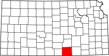 | |
| CDP | ||
| Unincorporated communities | ||
| Footnotes | ‡This populated place also has portions in an adjacent county or counties | |