South Bay Interchange
| South Bay Interchange | |
|---|---|
| Location | |
| South Bay, Boston, Massachusetts | |
| Coordinates: | 42°20′46″N 71°03′36″W / 42.346°N 71.060°WCoordinates: 42°20′46″N 71°03′36″W / 42.346°N 71.060°W |
| Roads at junction: |
|
| Construction | |
| Constructed: | 1997–2003 |
| Opened: | 2003 |
| Maintained by: | Massachusetts Department of Transportation |
| Map | |
 | |
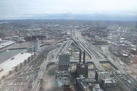
The South Bay Interchange is a massive interchange in the South Bay region of Boston, Massachusetts, in the US. The interchange consists of Interstate 90, the Mass Pike Extension, and the Interstate 93 concurrency with US 1 and MA 3 south of the Thomas P. O'Neill Jr. Tunnel.[1]
The interchange was constructed beginning in the late 1990s as a major feature of the Big Dig project. By using a variety of methods including soil freezing and tunnel jacking to maintain adjacent subway, freight and commuter rail operations, engineers were able avoid major interruption of existing traffic flows. The name South Bay originates from the state of the area prior to nineteenth century land reclamation efforts which filled an area of marshes and brackish water that was an estuary of Boston Harbor with dirt from nearby high ground.[2]
References
- ↑ "Land transfer agreement with the United States Postal Service" (PDF). Federal Highway Administration. 1997. p. 2. Retrieved 10 December 2009.
- ↑ Parker, Dave (January 8, 1998). "Boston tangler". London: New Civil Engineer. Retrieved 10 December 2009.
External links
- Design and Construction of Driven Pile Foundations: Lessons Learned on the Central Artery/Tunnel Project Federal Highway Administration