Songgan County
| Songgan County 성간군 | |
|---|---|
| County | |
| Korean transcription(s) | |
| • Hanja | 城干郡 |
| • McCune-Reischauer | Sŏnggan kun |
| • Revised Romanization | Seonggan-gun |
| Country | North Korea |
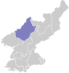
| Province | Chagang Province |
| Administrative divisions | ŭp, workers' districts, ri |
| Area | |
| • Total | 950 km2 (370 sq mi) |
| Population (1991 est.) | |
| • Total | 100,000 |
Songgan County is a kun, or county, in central Chagang province, North Korea. It borders Rangrim to the east, Wiwon to the west, Kanggye to the north and Chonchon and Ryongrim to the south. It was formed in 1952 from parts of Chonchon and Changgang, as part of a general reorganization of local government.
Songgan nestles among the Nangrim mountains in north central North Korea, its terrain sloping downward toward the Changja River in the west. The highest point is Maengbusan in the Rangrim range, which stands 2,214 m above sea level. 92% of the county's area is taken up by forestland.
The Manpo Line railroad follows the river through western Songgan. The county is also connected to Kanggye and Pyongyang by road. The chief local industries are logging and agriculture. Grains including maize, wheat, and millet are raised in Songgan, as are cattle and silkworms.
See also
External links
- (Korean) In Korean language online encyclopedias: