Chosan County
| Chosan County 초산군 | |
|---|---|
| County | |
| Korean transcription(s) | |
| • Hanja | 楚山郡 |
| • McCune-Reischauer | Ch'osan kun |
| • Revised Romanization | Chosan-gun |
| Country | North Korea |
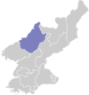
| Province | Chagang Province |
| Administrative divisions | 1 ŭp, 18 ri |
| Area | |
| • Total | 550 km2 (210 sq mi) |
| Population (1990 est.) | |
| • Total | 33,600 |
Ch'osan County is a kun, or county, in Chagang province, North Korea. It borders the People's Republic of China to the north.
The terrain slopes downward from the Kangnam Mountains in the south to the Yalu River in the north. The highest peak is Namhaetaesan (남해태산, 1,079 m). Some 20% of the land is arable, with animal husbandry and beekeeping playing important roles. 76.1% of the land is forested, and thus logging also contributes to the local economy.
The climate is continental, with hot summers and cold winters. The highest temperature recorded in North Korea, 41 °C, was recorded in the county in July 1961.[1]
During the Korean War on October 26, 1950, Republic of Korea forces reached the Yalu River at Chosan, shortly before the massive Chinese counterattack.
In 1999, a complex of Koguryo tombs was excavated in Chosan.[2]
Administrative Divisions
Ch'osan County is divided into 1 ŭp (town) and 18 ri (villages):
|
|
See also
References
External links
- (Korean) In Korean language online encyclopedias:
Coordinates: 40°36′11″N 125°18′22″E / 40.6030°N 125.3060°E