Sokongen Island
| Søkongen Ø | |
|---|---|
 Sokongen | |
| Geography | |
| Location | Greenland Sea |
| Coordinates | 68°10′N 30°45′W / 68.167°N 30.750°WCoordinates: 68°10′N 30°45′W / 68.167°N 30.750°W |
| Area | 115 km2 (44 sq mi) |
| Administration | |
| Municipality | Sermersooq |
| Demographics | |
| Population | 0 |
Sokongen (Danish: Søkongen Ø) is an island in the Sermersooq municipality, in eastern Greenland. .
Geography
Sokongen is a coastal island that lies between the Nansen Fjord to the northeast and the J.A.D. Jensen Fjord to the southwest. It is located in an indented area of the eastern Greenland shore where there is a succession of headlands with active glaciers in between.[1]
The island is 26 kilometres (16 miles) in length and its maximum width is 15 kilometres (9 miles).[2] Its SE headland is Cape J.A.D. Jensen (68°10'N., 29°48'W.), a massive rocky promontory with steep dark basalt cliffs rising almost 1,000 over the sea, located 15 km to the SW of Cape Nansen.[3]
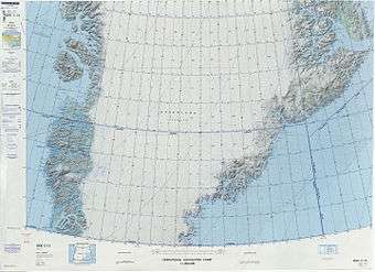 Map of Greenland section. |
See also
References
- ↑ Prostar Sailing Directions 2005 Greenland and Iceland Enroute, p. 110
- ↑ GoogleEarth
- ↑ "Søkongen Ø". Mapcarta. Retrieved 10 April 2016.
External links
This article is issued from Wikipedia - version of the 12/1/2016. The text is available under the Creative Commons Attribution/Share Alike but additional terms may apply for the media files.