Sermersooq
| Sermersooq Municipality Kommuneqarfik Sermersooq | ||
|---|---|---|
| Municipality | ||
|
| ||
| ||
 Location of Sermersooq within Greenland | ||
| Coordinates (Sermersooq Commune): 66°00′N 40°00′W / 66.000°N 40.000°WCoordinates: 66°00′N 40°00′W / 66.000°N 40.000°W | ||
| State |
| |
| Constituent country |
| |
| Municipality |
| |
| Established | 1 January 2009 | |
| Municipal center | Nuuk | |
| Government[1] | ||
| • Mayor | Asii Chemnitz Narup (Inuit Ataqatigiit) | |
| Area[2] | ||
| • Total | 531,900 km2 (205,400 sq mi) | |
| Population (2013)[3] | ||
| • Total | 21,868 | |
| • Density | 0.041/km2 (0.11/sq mi) | |
| Time zone | UTC-03, UTC-01 | |
| Calling code | +299 | |
| ISO 3166 code | GL-SM | |
| Website | sermersooq.gl | |
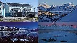
Sermersooq (Greenlandic: Kommuneqarfik Sermersooq, "Place of Much Ice") is a new municipality in Greenland, operational from 1 January 2009.[2] It is home to Nuuk (formerly called Godthåb), the capital of Greenland, and is the most populous municipality in the country, with 21,868 inhabitants as of January 2013.[3] The municipality consists of former municipalities of eastern and southwestern Greenland, each named after the largest settlement at the time of formation:[4]
- Ammassalik Municipality
- Ittoqqortoormiit Municipality
- Ivittuut Municipality
- Nuuk Municipality
- Paamiut Municipality
Towns and settlements
- Ammassalik area
- Tasiilaq (Ammassalik)
- Kuummiit
- Kulusuk (Kap Dan)
- Tiniteqilaaq
- Sermiligaaq
- Isortoq
- Ittoqqortoormiit area
- Ittoqqortoormiit (Scoresbysund)
- Ivittuut area
- Kangilinnguit (Grønnedal)
- Nuuk area
- Nuuk (Godthåb)
- Kapisillit
- Qeqertarsuatsiaat (Fiskenæsset)
- Paamiut area
Geography
The municipality is located in south-central and eastern Greenland, with the area of 531,900 km2 (205,367.7 sq mi).[2] It is the second largest municipality in the world by area,[2] after Qaasuitsup. In the south, it is flanked by the Kujalleq municipality, with the border running alongside Alanngorsuaq Fjord. The waters flowing around the western coastline of the municipality are that of Labrador Sea, which to the north narrows down to form Davis Strait separating the island of Greenland from Baffin Island.
In the northwest, the municipality is bordered by the Qeqqata municipality, and further north by the Qaasuitsup municipality. The latter border however runs north-south through the center (45° West meridian) of the Greenland ice sheet (Greenlandic: Sermersuaq) − and as such is free of traffic. In the north the municipality is bordered by the Northeast Greenland National Park. In the east, near the settlement of Ittoqqortoormiit, the municipal shores straddle the Kangertittivaq fjord, which empties into the cold Greenland Sea. The southeastern shores are bordered by the Anorituup Kangerlua fjord of the Irminger Sea in the North Atlantic Ocean.
Transport
Sermersooq is one of two municipalities straddling the western and eastern sides of the island, but is the only municipality where settlements on both coasts are connected via scheduled flights from Nuuk Airport to Kulusuk Airport and Nerlerit Inaat Airport and reverse, operated year-round by Air Greenland.[5] There are also local flights between Nuuk and Paamiut Airport on the west coast.
Language
Kalaallisut, the West Greenlandic dialect is spoken in the towns and settlements of the western coast. Danish is also in use in the bigger towns. Tunumiit oraasiat, the East Greenlandic dialect, is spoken on the eastern coast.
See also
References
| Wikimedia Commons has media related to Sermersooq. |
- ↑ Sermersooq Municipality: Administration
- 1 2 3 4 "Welcome to Kommuneqarfik Sermersooq". Sermersooq Municipality, Official Website. Retrieved 16 July 2010.
- 1 2 Greenland in Figures 2013 (PDF). Statistics Greenland. ISBN 978-87-986787-7-9. ISSN 1602-5709. Retrieved 2 September 2013.
- ↑ Sermersooq Municipality (Danish)
- ↑ "Booking system". Air Greenland. Retrieved 12 June 2010.
Administrative divisions of Greenland (since 2009) | ||
|---|---|---|
| Municipalities | ||
| Unincorporated Areas |
| |