Snake River Canyon (Wyoming)
| Snake River Canyon/Grand Canyon | |
 Snake River near Alpine, Wyoming | |
| Country | United States |
|---|---|
| State | Wyoming |
| County | Lincoln |
| Source | |
| - elevation | 5,800 ft (1,768 m) |
| - coordinates | 43°13′56″N 110°46′43″W / 43.23222°N 110.77861°W [1] |
| Mouth | Alpine, Wyoming |
| - elevation | 5,640 ft (1,719 m) [1] |
| - coordinates | 43°10′28″N 111°00′04″W / 43.17444°N 111.00111°WCoordinates: 43°10′28″N 111°00′04″W / 43.17444°N 111.00111°W [1] |
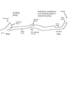
The Snake River Canyon (also known as the Grand Canyon) is formed by the Snake River in western Wyoming south of Jackson Hole.[2]
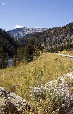
At the southern end of this canyon is the town of Alpine, Wyoming where the Snake River meets the Greys River and the Salt River at Palisades Reservoir on the Wyoming-Idaho border. It is a popular destination for rafting trips and is known for having some of the best white-water rafting in the United States. Running through the canyon is Highway 89.
Geology
The Snake River cuts through a fold and thrust belt on its way from Hoback, Wyoming to Alpine, Wyoming. The North American Plate has pushed against the Farallon Plate to create many geologic features including the folds and thrusts visible in the Snake River Canyon in Wyoming.
References
- 1 2 3 "Grand Canyon". Geographic Names Information System. United States Geological Survey. Retrieved 2013-1-20. Check date values in:
|access-date=(help) - ↑ Pine Creek, WY (Map). TopoQwest (United States Geological Survey Maps). Retrieved 2013-1-20. Check date values in:
|access-date=(help)