Jackson Hole
Jackson Hole is a valley between the Teton Mountain Range and the Gros Ventre Range in Wyoming. The term "hole" was used by early trappers or mountain men, who primarily entered the valley from the north and east and had to descend along relatively steep slopes, giving the sensation of entering a hole. These low-lying valleys are surrounded by mountains and contain rivers and streams, which were good habitat for beaver and other fur-bearing animals.
History
The town of Jackson was named in late 1893 by Margaret Simpson, who at the time was receiving mail at her home as there was no post office. She named the town in order for easterners to be able to forward mail west. Jackson, which became incorporated in 1914, was named after David Edward "Davey" Jackson who trapped beaver in the area in the late 1820s while a partner in the firm of Smith, Jackson & Sublette.[1] Davy Jackson was one of the first white men to spend an entire winter in the Valley of the Teton Mountains.[2] Though used by Native Americans for hunting and ceremonial purposes, the valley was not known to harbor year-round human settlement prior to the 1870s. Descriptions of the valley and its features were recorded in the journals of John Colter, who had been a member of the Lewis and Clark Expedition. After returning to the Rocky Mountains, Colter entered the region in 1807 in the vicinity of Togwotee Pass and became the first white American to see the valley. His reports of the valley, the Teton Range and the Yellowstone region to the north were viewed by people of the day with skepticism.
The first people to settle the region were Native Americans, then fur trappers, and then homesteaders. Because the soil is not ideal for raising crops, the valley was used for cattle. Tourism quickly became popular with the establishment of dude ranches.
Settlements
The only incorporated town in the valley is Jackson, also called Jackson Hole. Other communities in the valley include Wilson, Teton Village, Moran Junction, Hoback, Moose (Moose Wilson Road), and Kelly. On the west side of the valley, Teton Pass crosses the Teton Range providing access to Victor and Driggs in eastern Idaho and Alta, Wyoming on the western side of the Tetons. Numerous elk use the valley as grazing range during the winter, and sleigh rides are offered to tourists. The Jackson Hole Mountain Resort, Snow King and Grand Targhee Resort ski areas, and nearby Grand Teton and Yellowstone national parks are major tourist attractions throughout all seasons of the year.
Geography
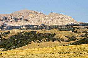
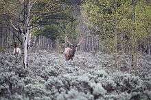
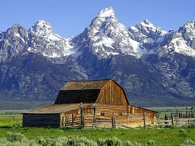
The valley is formed by the Teton Range on the western side and the Gros Ventre Range on the eastern side. Grand Teton National Park occupies the north-western part of the valley encompassing much of the Teton Range as well as Jackson Lake. The town of Jackson, Wyoming, is at the southern end. Between them lies, on U.S. Route 26, "Glacier View Turnout" offering a view of Teton Glacier on the north of Grand Teton,[3] and the National Elk Refuge, home of the largest elk herd on earth. The Snake River threads through the entire valley from its headwater in Yellowstone in the north to the mouth of the Snake River Canyon at the southern tip of the valley. Blacktail Butte is a prominent landform rising from the valley floor. The average altitude of the valley is over 6,500 feet (2,000 m).
Climate
High altitude and steep mountain slopes on all sides of the valley often cause calm winter nights to be very cold, as radiational cooling from snow-covered ground creates cold air near the surface, which then slides down into the valley due to its higher density. In 1993, this effect during an already severe cold snap plunged the morning low temperature down to −56 °F (−49 °C) in the valley, officially recorded by the National Weather Service. The state record low temperature was also recorded in the valley at Moran at −66 °F (−54 °C) in 1933. Summers are warm to mild, due to the surrounding mountains.
Economy
Jackson Hole Airport is the largest and busiest commercial airport in Wyoming. Strict noise abatement regulations and the terminal building's low profile allow for the airport to operate within Federal guidelines inside Grand Teton National Park. However, it becomes difficult to fly in the winter months. Major airlines serve the valley with jet service, some of which is seasonal (summer and winter).
The Federal Reserve Bank of Kansas City has hosted an annual economic policy symposium at Jackson Lake Lodge since 1982. They chose Jackson Hole in 1982 because of its trout fishing, as they were trying to attract Paul Volcker, who was Chairman of the Federal Reserve and a keen fly-fisherman.[4][5]
See also
Notes
- ↑ Hays, Carl D. W. (1983). "David E. Jackson". In Leroy R. Hafen. Trappers of the Far West: Sixteen Biographical Sketches. Lincoln: University of Nebraska Press. pp. 80–81. ISBN 0-8032-7218-9.originally published in Leroy R. Hafen, ed. (1972). Mountain Men and Fur Traders of the Far West vol. IX. Glendale: The Arthur H Clark Company.
- ↑ Mattes, Merrill J. "Grand Teton NP/Yellowstone NP: Colter's Hell and Jackson's Hole (Chapter 6)". Colter's Hell and Jackson's Hole. Yellowstone Library and Museum Association, and Grand Teton Natural HIstory Association, in cooperation with National Park Service. Retrieved 22 May 2013.
- ↑ Grand Teton National Park Photographer's Map & Guide. Earthwalk Press. 2008. ISBN 978-0-915749-25-6.
- ↑ Zeitlin, Matthew (31 August 2012). "Summer camp for bankers". The Daily Beast. Retrieved 23 March 2013.
- ↑ Wiseman, Paul (30 August 2012). "Why world markets focus on tiny Jackson Hole, Wyo.". USA Today. Retrieved 23 March 2013.
References
- Daugherty, John. "A Place Called Jackson Hole". Grand Teton Natural History Association. Retrieved 2006-10-06.
- "The Mystery of the Colter Stone". Grand Teton National Park. Retrieved 2009-10-01.
Coordinates: 43°31′N 110°50′W / 43.517°N 110.833°W