Ysgyryd Fawr
| Ysgyryd Fawr | |
|---|---|
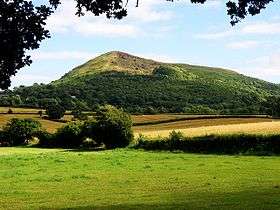 Ysgyryd Fawr from the north | |
| Highest point | |
| Elevation | 486 m (1,594 ft) |
| Prominence | 344 m (1,129 ft) |
| Parent peak | Sugar Loaf |
| Listing | Marilyn |
| Naming | |
| Translation | Great shattered [hill] (Welsh) |
| Pronunciation | Welsh: [ɐsˈɡɐɾɪd ˈvæuɾ] |
| Geography | |
| Location | Monmouthshire, Wales |
| Parent range | Black Mountains |
| OS grid | SO331182 |
| Topo map | OS Landranger 161 |
Ysgyryd Fawr (English: Skirrid Fawr) is an easterly outlier of the Black Mountains in Wales, and forms the easternmost part of the Brecon Beacons National Park. The mountain is often referred to locally as just The Skirrid.[1] The smaller hill of Ysgyryd Fach or 'Little Skirrid' (270m) lies about 4.5 km / 2.5 mi to the south.
It is 486 m or 1594 feet high and lies just to the north-east of Abergavenny, Monmouthshire, about 10 miles from the English border. The Beacons Way passes along the ridge.[2]
Geology
.jpg)
The distinctive shape of this Old Red Sandstone hill comprises a long ridge oriented nearly north–south, with a jagged western side resulting from ice age landslips .[3] The upper slopes of the hill are composed of Devonian age sandstones assigned to the Senni Formation (formerly known as the 'Senni Beds'). These overlie weaker mudstones of the St Maughans Formation - a situation which has contributed to the instability of the hill's steep flanks, resulting in a very large landslip at the northern end of the mountain, although the British Geological Survey map of the area (Abergavenny sheet) shows the landslide extending along the whole of the west side of the mountain. There are numerous other landslips of a similar nature on the nearby hills, although that on the Skirrid is perhaps the most well known owing to its visibility from several directions. There are also numerous rock tables on the hill, some of which were formed by the landslide, and have attracted names such as the "Devil's table".[4] The ridge is very similar in its rocky edge to that found on the Black Hill to the north in Herefordshire.
Cultural associations
The Welsh name Ysgyryd meaning 'split' or 'shattered' and Fawr meaning 'great' describes the hill's shape.[5] There is a rich mythology attached to the mountain ,[6][7] including a distinctive stone known as the Devil's Table. According to legend, part of the mountain is said to have been broken off at the moment of the crucifixion of Jesus.[8] There was a local tradition that earth from the Skirrid was holy and especially fertile, and it was taken away to be scattered on fields elsewhere, on coffins, and in the foundations of churches.[9] Pilgrimages were made, especially on Michaelmas Eve, to the summit.
History
.jpg)

In older literature the spelling Skyrrid is sometimes encountered and the mountain is also referred to locally as the Holy Mountain or Sacred Hill.[8] The ruins of an iron–age hill fort and a mediæval chapel, dedicated to St. Michael, lie at the summit.[10][11] Rudolf Hess used to walk here when he was held prisoner at nearby Maindiff Court during the early 1940s. [6] There is an pub called The Skirrid Mountain Inn just to the north of the mountain in Llanvihangel Crucorney, which claims to be one of the oldest pubs in Wales. This mountain site "..a stark barren monolith.." is also mentioned in the recent book by Pete "Snapper" Winner, Soldier 'I' - The Story of an SAS Hero[12] as part of Sickener 2, his Selection for the SAS.
Ownership and access
Ysgyryd Fawr has belonged to the National Trust since 1939. The summit offers views of the Sugar Loaf to the west, and Blorenge to the south, and the ridge is easily accessed on foot from the car park beside the B4521 Ross Road shown on the Ordnance Survey maps. The ascent is steep initially through woods, but gradual thereafter as open ground is reached, and a fine walk along the spine of the mountain to the highest point at the north end of the mountain at the trig point and chapel; allow two hours for the completion and return in good weather. A rough path follows the perimeter of the hill at a much lower level, and can be used as a circular route.
References
- ↑ Hughes, Annabel (4 May 2016). "New Skirrid car park opened". Abergavenny Chronicle. Tindle Newspapers Ltd. Retrieved 26 May 2016.
- ↑ "Beacons Way". Brecon Beacons National Park Authority.
- ↑ Mountain Hut Productions (9 July 2003). "The Skirrid (Ysgyryd Fawr) Holy Mountain".
- ↑ British Geological Survey: memoir to Abergavenny geological map sheet 232
- ↑ Rickard, Trevor. "The Ysgyryd Fawr Landslip". Geograph.org.uk. Retrieved 26 May 2016.
- 1 2 Llanddewi Skirrid. "Facts and Fiction of Skirrid Fawr". Archived from the original on September 29, 2007. Retrieved November 4, 2006.
- ↑ Rhiannon (8 March 2005). "Ysgyryd Fawr". The Modern Antiquarian.
- 1 2 "Skirrid Fawr walk, a mountain of mud and myths". National Trust. Retrieved 28 June 2016.
- ↑ Roy Palmer, The Folklore of (old) Monmouthshire, 1998, ISBN 1-873827-40-7
- ↑ "St Michael's Chapel". Historic Environment Record (HER). Glamorgan-Gwent Archaeological Trust (GGAT). PRN GGAT01473g. Retrieved 28 June 2016 – via archwilio (online database of the four Welsh Archaeological Trusts).
- ↑ "Ysgyryd (Skirrid) Fawr hillfort". Historic Environment Record (HER). Glamorgan-Gwent Archaeological Trust (GGAT). PRN GGAT01497g. Retrieved 28 June 2016 – via archwilio (online database of the four Welsh Archaeological Trusts).
- ↑ ISBN 978-1-84603-995-9; pp 39
External links
| Wikimedia Commons has media related to Skirrid. |
Coordinates: 51°51′30″N 2°58′15″W / 51.858386°N 2.970816°W