Brecon Beacons National Park
| Brecon Beacons National Park (Parc Cenedlaethol Bannau Brycheiniog) | |
| Protected Area | |
| Country | Wales |
|---|---|
| Council | Blaenau Gwent, Carmarthenshire, Merthyr Tydfil, Powys, Rhondda Cynon Taf, Monmouthshire, Torfaen, Caerphilly |
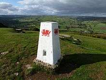
| Highest point | Pen y Fan |
| - elevation | 886 m (2,907 ft) |
| Area | 1,344 km2 (519 sq mi) |
| National Park of Wales | 1957 |
| IUCN category | V - Protected Landscape/Seascape |
| Website: beacons-npa.gov.uk | |
The Brecon Beacons National Park (Welsh: Parc Cenedlaethol Bannau Brycheiniog) is one of three national parks in Wales, and is centred on the Brecon Beacons range of hills in southern Wales. It includes the Black Mountain (Welsh: Y Mynydd Du) in the west, Fforest Fawr (Great Forest) and the Brecon Beacons in the centre and the Black Mountains (Welsh: Y Mynyddoedd Duon) in the east.
Description
The Brecon Beacons National Park was established in 1957, the third of the three Welsh parks after Snowdonia in 1951 and the Pembrokeshire Coast in 1952. It stretches from Llandeilo in the west to Hay-on-Wye in the northeast and Pontypool in the southeast, covering 519 square miles (1,340 km2) and encompassing four main regions – the Black Mountain in the west, Fforest Fawr and the Brecon Beacons in the centre, and the confusingly named Black Mountains in the east. The western half gained European and Global status in 2005[1] as Fforest Fawr Geopark. This includes the Black Mountain, the historic extent of Fforest Fawr, and much of the Brecon Beacons and surrounding lowlands.
The entire National Park achieved the status of being an International Dark Sky Reserve in February 2013.[2]
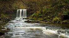
Most of the National Park is bare, grassy moorland grazed by Welsh mountain ponies and Welsh mountain sheep, with scattered forestry plantations, and pasture in the valleys. It is known for its remote reservoirs, waterfalls including the 90-foot (27 m) Henrhyd Waterfall and the falls at Ystradfellte, and its caves, such as Ogof Ffynnon Ddu. The Brecon Beacons Mountain Centre was opened in 1966 to help visitors understand and enjoy the area.
Activities in the Park include walking, cycling, mountain biking, horse riding, as well as sailing, windsurfing, canoeing and fishing, rock climbing, hang-gliding, caravanning, camping and caving. A long-distance cycling route, the Taff Trail, passes over the Beacons on its way from Brecon to Cardiff, and in 2005 the first walk to span the entire length of the Brecon Beacons National Park was opened. The 100-mile (161 km) route, called the Beacons Way, runs from the foot of Ysgyryd Fawr east of Abergavenny and ends in the village of Bethlehem in Carmarthenshire.
Due to the relative remoteness and harsh weather of some of its uplands, the Park is used for military training. UK Special Forces, including the SAS and SBS hold demanding selection training exercises here, such as an exercise called the Fan dance. The infantry regiments of the British Army train at Sennybridge, where NCO selection also takes place.
In 2006 and 2007, controversy surrounded the government decision to build the South Wales Gas Pipeline through the Park, the National Park Authority calling the decision a “huge blow”.[3]
Local government
The Brecon Beacons National Park Authority is a special purpose local authority which exercises planning functions across the designated area of the park. The park extends across the southern part of Powys, the northwestern part of Monmouthshire and parts of eastern Carmarthenshire. It also includes the northernmost portions of several of the unitary authority areas which are centred on the coalfield communities to the south and including the county boroughs of Neath Port Talbot, Rhondda Cynon Taf, Merthyr Tydfil and Blaenau Gwent together with very small parts of Caerphilly and Torfaen.
Numerous town and community councils operate within these areas and include those for Brecon and Hay on Wye (town councils) and Cefn Coed; Llanfihangel Cwmdu with Bwlch and Cathedine; Llangattock; Llangors; Llanthony; Llywel; Pontsticill, Pontsarn and Vaynor; Talybont-on-Usk; Trallong; Trecastle and Ystradfellte (all community councils).
Activities
The Brecon Beacons National Park attracts many visitors due to the range and quality of outdoor activities the park offers. These include hill walking, climbing, gorge-walking, caving, horse-riding and mountain biking.

Brecon Mountain Railway
A popular railway with narrow gauge trains run by the Brecon Mountain Railway.
References
- ↑ Welcome – Brecon Beacons National Park, Wales. Breconbeacons.org. Retrieved on 2014-05-24.
- ↑ Brecon Beacons at the International Dark-Sky Association
- ↑ Controversial National Grid Pipeline given the go ahead! Archived May 9, 2007, at the Wayback Machine. Brecon Beacons National Park Authority
External links
- Official site of the Brecon Beacons National Park Authority
- The Brecon Beacons Park Society, the 'Friends' organisation of the Park
- Tourist Information Brecon Beacons Park, Official Brecon Beacons Tourism Association
- Information About Brecon Beacons National Park
Coordinates: 51°53′N 3°26′W / 51.883°N 3.433°W