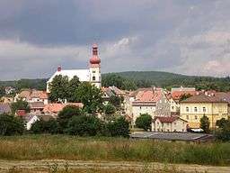
Skalná
| Skalná | |||
| Town | |||
 | |||
|
|||
| Country | Czech Republic | ||
|---|---|---|---|
| State | Bohemia | ||
| Region | Karlovy Vary | ||
| District | Cheb | ||
| Commune | Cheb | ||
| River | Sázek | ||
| Elevation | 465 m (1,526 ft) | ||
| Coordinates | CZ 50°10′13″N 12°21′41″E / 50.17028°N 12.36139°ECoordinates: CZ 50°10′13″N 12°21′41″E / 50.17028°N 12.36139°E | ||
| Highest point | Lužský vrch | ||
| - elevation | 606 m (1,988 ft) | ||
| Area | 23.44 km2 (9.05 sq mi) | ||
| Population | 1,896 (2014-12-31) | ||
| Density | 81/km2 (210/sq mi) | ||
| Founded | 12th century | ||
| Mayor | Mgr. Rita Skalová (ODS) | ||
| Timezone | CET (UTC+1) | ||
| - summer (DST) | CEST (UTC+2) | ||
| Postal code | 351 34 | ||
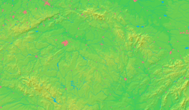  Location in the Czech Republic | |||
 Location in Cheb District | |||
| Wikimedia Commons: Skalná | |||
| Statistics: statnisprava.cz | |||
| Website: www | |||

Skalná (Czech pronunciation: [ˈskalnaː]; Vildštejn (until 1950), German: Wildstein) is situated in the Czech Republic in the Karlovy Vary Region in proximity of German border. Most of the area lies in the Cheb basin, in the nord it's located first hills of Smrčiny.
Parts
Villages Kateřina (Katharinadorf), Starý Rybník (Altenteich), Vonšov (Fonsau) and Zelená (Grün) are administrative parts of Skalná.
Sights
- Romanesque Vildštejn castle
- Baroque Church of John the Baptist
- Unique Nature reservation SOOS
External links
- (Czech) Municipal website
-
 Media related to Skalná at Wikimedia Commons
This article is issued from Wikipedia - version of the 4/5/2016. The text is available under the Creative Commons Attribution/Share Alike but additional terms may apply for the media files.