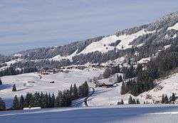
Sibratsgfäll
| Sibratsgfäll | ||
|---|---|---|
 | ||
| ||
 Sibratsgfäll Location within Austria | ||
Location in the district
| ||
| Coordinates: 47°25′36″N 10°02′17″E / 47.42667°N 10.03806°ECoordinates: 47°25′36″N 10°02′17″E / 47.42667°N 10.03806°E | ||
| Country | Austria | |
| State | Vorarlberg | |
| District | Bregenz | |
| Government | ||
| • Mayor | Konrad Stadelmann | |
| Area | ||
| • Total | 29.25 km2 (11.29 sq mi) | |
| Elevation | 929 m (3,048 ft) | |
| Population (1 January 2016)[1] | ||
| • Total | 395 | |
| • Density | 14/km2 (35/sq mi) | |
| Time zone | CET (UTC+1) | |
| • Summer (DST) | CEST (UTC+2) | |
| Postal code | 6952 | |
| Area code | 05513 | |
| Vehicle registration | B | |
| Website | www.sibra.at | |

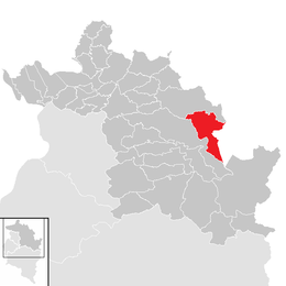
Sibratsgfäll is a municipality in the district of Bregenz in the Austrian state of Vorarlberg.
Population
| Historical population | ||
|---|---|---|
| Year | Pop. | ±% |
| 1869 | 304 | — |
| 1880 | 352 | +15.8% |
| 1890 | 289 | −17.9% |
| 1900 | 267 | −7.6% |
| 1910 | 284 | +6.4% |
| 1923 | 268 | −5.6% |
| 1934 | 270 | +0.7% |
| 1939 | 256 | −5.2% |
| 1951 | 340 | +32.8% |
| 1961 | 330 | −2.9% |
| 1971 | 308 | −6.7% |
| 1981 | 367 | +19.2% |
| 1991 | 404 | +10.1% |
| 2001 | 422 | +4.5% |
| 2011 | 393 | −6.9% |
References
| Wikimedia Commons has media related to Sibratsgfäll. |
This article is issued from Wikipedia - version of the 6/9/2016. The text is available under the Creative Commons Attribution/Share Alike but additional terms may apply for the media files.