Shweli River
| Shweli River | |
|---|---|
|
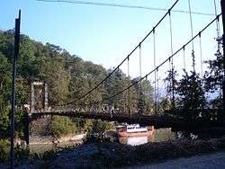
Bridge over River Shweli | |
 | |
| Native name | Nam Mao / 瑞丽江 |
| Country | Myanmar, China |
| Basin | |
| Main source | Shan Hills |
| River mouth |
Ayeyarwady River by Inywa 89 m (292 ft) 23°56′49″N 96°17′0″E / 23.94694°N 96.28333°ECoordinates: 23°56′49″N 96°17′0″E / 23.94694°N 96.28333°E |
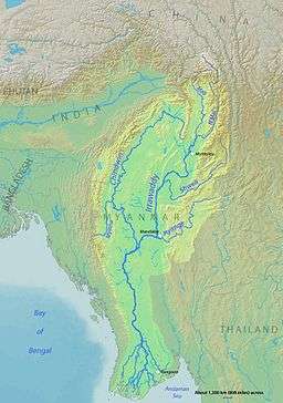
Shweli River (Burmese: ရွှေလီမြစ်) is a river in Myanmar (Burma). Also known as Nam Mao in Shan and Lung Chuan Chiang in Chinese, it forms part of the boundary between Burma and China.[1] It is one of the tributaries of the country's chief river, the Ayeyarwady, and arises in Yunnan Province of China. It flows through northern Shan state and Sagaing Division, and enters the Ayeyarwady at Inywa, 60 km north of Tagaung and south of Katha.
History
Tai people, known as Shan in Burma, migrated from Yunnan into Burma along the Shweli.[2] Maw Shans from Mong Mao settled in the Shweli valley, and raided and invaded the Bamar heartlands down the Shweli, but King Anawrahta of Bagan (1044–1077) reduced them to a vassal state. The fall of the kingdom of Bagan in the 13th century, however, saw a resurgence of Shan power, although King Bayinnaung (1551–1581) of the Taungoo Dynasty succeeded in pacifying them to establish Burmese suzerainty once and for all.[2][3] King Hsinbyushin (1763–1776) of the Konbaung Dynasty also successfully repelled Chinese invasions (1765-9) that advanced down the Shweli and Myitnge river valleys.[3]
The territory south of the Shweli, about 500–600 km2, north of Namtu and from Namkham to the west, was under the control of the Communist Party of Burma (CPB) from 1968 to 1986. The Kachin Independence Army (KIA) controlled the area north of the Shweli, and the Shan State Army (SSA) and the Palaung State Liberation Army (PSLA) farther south. The Shweli river valley and the hills around Momeik (Mong Mit) and Mogok with its ruby mines had been old CPB strongholds since the 1950s. Momeik itself was captured by the Communists in 1977. The Burmese Army recaptured the territory in early 1987, and subsequently opened up border trade with China.[4]
Population
The region is inhabited mainly by Shan and Palaung peoples, some Kachin and a few Chinese.[4]
Flora and fauna
There are extensive marshes on both banks of the Shweli at the confluence with the Ayeyarwady. Hills are covered with broad-leaved species of Terminalia and Shorea trees. Rhododendron edgeworthii, of the finest foliage and flowers ranging in colour from white to white flushed pink or pink, sometimes with a yellow blotch, was part of a collection made in 1997 on the Shweli - Salween divide on the Yunnan border with Burma.[5]
White-winged wood duck (Cairina scutulata), an endangered species of forest duck, and the sarus crane (Grus antigone) are native to the Shweli river. The gharial (Gavialis gangeticus), a crocodilian, was last spotted in 1927.[6] The Irrawaddy dolphin has been known to reach the upper tributaries of the Ayeyarwady including the Shweli.[7]
Towns
Trade and commerce
Muse is connected to Ruili on the Chinese side, and a roaring trade in goods and services was engaged in across the "Gun Bridge", so called because of the armaments transported from China to the military government of Burma.[8][9] The old bridge was replaced by a new wider one in 2005. Gems especially jade and produce, and illicit heroin, are exported in exchange for cheap motorcycles and household goods from China.[10]
More recently, Chinese hybrid rice called sinn shweli has been introduced by the military authorities to the local farmers as part of the opium eradication drive, most of the crop to be exported back to China.[11]
The Shweli I Dam was put into operation on the river in 2008. It is the first of three planned dams on the main stem.[12]
Notes
- ↑ "International Boundary Study No. 42 - November 30, 1964: Burma - China Boundary" (PDF). Florida State University. Retrieved 2008-10-24.
- 1 2 Nisbet, John. Burma Under British Rule and Before. Adamant Media Corporation, 2005. p. 416. ISBN 978-1-4021-5293-1. Retrieved 2008-10-24.
- 1 2 Harvey, G E. History of Burma: From the Earliest Times to 10 March 1824. Asian Educational Services, 2000. pp. 165, 254. ISBN 978-81-206-1365-2. Retrieved 2008-10-24.
- 1 2 Lintner, Bertil (1990). The Rise and Fall of the Communist Party of Burma (CPB). SEAP Publications. pp. 79–80. ISBN 978-0-87727-123-9. Retrieved 2009-01-31.
- ↑ "Species Foundation Rhododendrons". The American Rhododendron Society, 1997-2002. Retrieved 2008-10-24.
- ↑ "Upper Irrawaddy and Mogawng Chaung". ARCBC (ASEAN Regional Centre for Biodiversity Conservation). Retrieved 2008-10-24.
- ↑ "Orcaella brevirostris". ICUN Red List. Retrieved 2008-10-24.
- ↑ "Burma Road". National Geographic Magazine, July 1995. Retrieved 2008-10-25.
- ↑ Mansfield, Stephen. "Myanmar's Chinese Connection". The Japan Times, May 13, 1999. Retrieved 2008-10-25.
- ↑ Fullbrook, David. "Inland China's route to prosperity". Asia Times Sep 30, 2006. Retrieved 2008-10-25.
- ↑ McCoy, Clifford. "Seedlings of evil growing in Myanmar". Asia Times Aug 23, 2007. Retrieved 2008-10-25.
- ↑ "Myanmar Shweli River power plant put into operation the first unit". China Water Science and Technology Network. Retrieved 11 March 2014.
External links
 Media related to Shweli River at Wikimedia Commons
- Shweli River Google map GeoNames
- Shan State map R4 = Shweli River Asterism
- Sagaing Division map R3 = Shweli River Asterism
- Photo of the "Gun Bridge" over the Shweli Renaud Egreteau
- 3rd Destruction of Narcotic Drugs Ceremony, 26 November 1999 myanmar-narcotic.net