Shigar District
| Shigar District | |
|---|---|
| District | |
| Coordinates: PK 35°26′N 75°44′E / 35.433°N 75.733°E | |
| Country | Pakistan |
| Province | Gilgit-Baltistan |
| Headquarters | Shigar |
| Area | |
| • Total | 8,500 km2 (3,300 sq mi) |
| Population | |
| • Estimate (1998) | 109,000 |
| Time zone | PST (UTC+5) |
Shigar District, a political sub-division of Pakistan, is part of Baltistan and currently constitutes one of the nine districts of the Gilgit–Baltistan territory of Pakistan. It is bounded on the southeast by Kargil district in the Indian-Administered Jammu and Kashmir, on the east by Ghanche District, on the northeast by Xinjiang (China), on the south by Baramulla and Kargil District, on the west by district Astore and on the north by Gilgit District.
Shigar town is the capital of Shigar District.
| Wikimedia Commons has media related to Shigar District. |
| Passes | 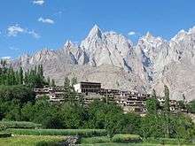 | |
|---|---|---|
| Valleys | ||
| Cities and towns | ||
| Rivers, glaciers and lakes | ||
| Architecture | ||
| See also | ||
This article is issued from Wikipedia - version of the 9/1/2015. The text is available under the Creative Commons Attribution/Share Alike but additional terms may apply for the media files.