Skardu
| Skardu | |
|---|---|
| Town | |
|
Shangrila Resort Skardu | |
 Skardu  Skardu Location in the Karakoram region | |
| Coordinates: 35°17′25″N 75°38′40″E / 35.29028°N 75.64444°ECoordinates: 35°17′25″N 75°38′40″E / 35.29028°N 75.64444°E | |
| Country | Pakistan |
| Province | Gilgit–Baltistan |
| District | Skardu |
| Elevation | 2,228 m (7,310 ft) |
| Population | |
| • | 500,600 |
| Time zone | PST (UTC+5:00) |
| • Summer (DST) | GMT+5:00 (UTC) |
| Website | http://www.skardu.pk/ |

Skardu (Urdu: اسکردو, Balti: སྐརདུ་་ from Tibetan: སྐར་རྡོ་, THL: skar rdo "stony meteorite") is a town and the capital of Skardu District in Gilgit-Baltistan, Pakistan. Skardu is located in the 10 kilometres (6 miles) wide by 40 kilometres (25 miles) long Skardu Valley, at the confluence of the Indus and Shigar Rivers.[1] Skardu is at an altitude of nearly 2,500 metres (8,202 feet). The town is surrounded by grey-brown coloured mountains beyond which lie the eight-thousanders of the nearby Karakoram. Skardu is located in between the Karakoram and Himalayas. The Indus river separates Karakoram with Himalayas. [2]
History

The first mention of Skardu dates to the first half of the 16th century. Mirza Haidar (1499–1551) described Askardu in the 16th century text Tarikh-i-Rashidi Baltistan as one of the districts of this country. With the conquest of Kashmir in 1586 by the Mughal Emperor Akbar (1556–1605), started by Ali Sher Khan Anchan, the kings of Skardu were mentioned as rulers of Little Tibet in the historiography of the Mughal Empire. These are, in particular, histories of Al-Badaoni, Abu'l Fazl, 'Abdu-l Hamid Lahori, Saqi Must'ad Khan and Inayat Khan.[3]
The first mention of Skardu in European literature was made by Frenchman François Bernier (1625–1688). Bernier was a physician and world traveler who reached India in 1659 and in 1663, in the wake of the Mughal emperor Aurangzeb, traveled to Kashmir. In 1670, he described his encounter with a King of Little Tibet — one related to Murad Khan — and mentions Eskerdou (Skardu) as one of the places of Baltistan in his travel memoirs. After this mention of Little Tibet and Skardu through the country, Little Tibet and Skardu were quickly drawn into Asian maps produced in Europe. Skardu was first mentioned as Eskerdow the map "Indiae orientalis nec non insularum adiacentium nova descriptio" by Nicolaes Visscher II, published 1680-1700, and the first recorded Baltistan as Tibet Minor.
Geography
Skardu is in the 10 kilometres (6 miles) wide by 40 kilometres (25 miles) long Skardu Valley, at the confluence of the Indus river (flowing from near Kailash in Tibet and through neighbouring Ladakh before reaching Baltistan) and the Shigar River. It is at an altitude of nearly 2,500 m (8,200 ft).
Tourism
Skardu, along with Gilgit, is a major tourism, trekking and expedition hub in Gilgit–Baltistan. The mountainous terrain of the region, which includes four of the world's 14 Eight-thousander peaks, attracts tourists, trekkers and mountaineers from around the world. The main tourist season is from April to October; except at this time, the area can be cut off for extended periods by the snowy, freezing winter weather.
Accessible from Skardu by road, the nearby Askole and Hushe are the main gateways to the snow-covered 8,000 m peaks including K2, the Gasherbrums, Broad Peak, and the Trango Towers, and to the huge glaciers of Baltoro, Biafo and Trango. This makes Skardu the main tourist and mountaineering base in the area, which has led to the development of a reasonably extensive tourist infrastructure including shops and hotels. The popularity of the region results in high prices, especially during the main trekking season.
Treks to the Deosai Plains, the second highest in the world at 4,114 metres (13,497 ft) above sea level, after the Chang Tang in Tibet, either start from or end at Skardu. In the local Balti language, Deosai is called Byarsa, meaning 'summer place'. With an area of approximately 3,000 square kilometres (1,158 sq mi), the plains extend all the way to Ladakh and provides a habitat for snow leopards, ibex, Tibetan blue bears and wild horses.
Climate and geology
_skardu._photo_by_me.jpg)
The climate of Skardu during the summer is moderated by its mountain setting; the intense heat of lowland India does not reach it. The mountains block out the summer monsoon, and summer rainfall is thus quite low. However, these mountains result in very severe winter weather. During the April-to-October tourist season, temperatures vary between a maximum of 27 °C (81 °F) and a minimum (in October) 8 °C (46 °F).
Temperatures can drop to below −10 °C (14 °F) in the December-to-January midwinter period. The lowest recorded temperature was −24.1 °C (−11 °F) on 7 January 1995.[4]
The Shigar River is a tributary to the Indus River, joining at the town of Skardu. The Basha and Braldu rivers are northern tributaries of the Shigar. Numerous complex granitic pegmatites and a few alpine-cleft metamorphic deposits are found in the Shigar Valley and its tributaries. Shigar Valley contains the Main Karokoram Thrust separating the metasediments (chlorite to amphibolite grade) on the Asian plate from the southern volcanoclastic rocks of the Kohistan-Ladakh island arc.
| Climate data for Skardu | |||||||||||||
|---|---|---|---|---|---|---|---|---|---|---|---|---|---|
| Month | Jan | Feb | Mar | Apr | May | Jun | Jul | Aug | Sep | Oct | Nov | Dec | Year |
| Record high °C (°F) | 13.9 (57) |
16.7 (62.1) |
24.0 (75.2) |
29.6 (85.3) |
34.4 (93.9) |
40.0 (104) |
41.0 (105.8) |
41.0 (105.8) |
38.2 (100.8) |
31.2 (88.2) |
22.9 (73.2) |
16.2 (61.2) |
41.0 (105.8) |
| Average high °C (°F) | 3.2 (37.8) |
6.1 (43) |
12.4 (54.3) |
18.8 (65.8) |
23.4 (74.1) |
28.7 (83.7) |
31.6 (88.9) |
31.2 (88.2) |
27.2 (81) |
20.4 (68.7) |
13.2 (55.8) |
6.5 (43.7) |
14.9 (58.8) |
| Average low °C (°F) | −8.0 (17.6) |
−4.4 (24.1) |
1.5 (34.7) |
6.6 (43.9) |
9.7 (49.5) |
13.4 (56.1) |
16.4 (61.5) |
16.0 (60.8) |
11.4 (52.5) |
4.3 (39.7) |
−1.9 (28.6) |
−5.6 (21.9) |
4.1 (39.4) |
| Record low °C (°F) | −24.1 (−11.4) |
−20.0 (−4) |
−13.5 (7.7) |
−1.1 (30) |
0.4 (32.7) |
4.0 (39.2) |
7.5 (45.5) |
7.0 (44.6) |
2.6 (36.7) |
−4.2 (24.4) |
−9.5 (14.9) |
−17.2 (1) |
−24.1 (−11.4) |
| Average rainfall mm (inches) | 27.5 (1.083) |
25.9 (1.02) |
36.9 (1.453) |
31.3 (1.232) |
25.3 (0.996) |
9.0 (0.354) |
9.8 (0.386) |
12.2 (0.48) |
9.3 (0.366) |
7.3 (0.287) |
5.6 (0.22) |
16.3 (0.642) |
172.7 (6.799) |
| Average relative humidity (%) (at 17:00 PST) | 64.3 | 52.0 | 34.9 | 25.6 | 24.6 | 22.3 | 27.3 | 30.7 | 29.9 | 31.2 | 36.6 | 56.2 | 29.6 |
| Source: Pakistan Meteorological Department[4] | |||||||||||||
Transport

Skardu is accessible by two methods, road or air. The normal road route into Skardu is via the Karakorum Highway and a Skardu Road (S1) into the Skardu Valley from it. There are four or five road links to Srinagar and Leh. Alternatively, there are one or two flights daily between Skardu Airport and Islamabad.
The climate can have adverse effects on transport in and out of the Skardu Valley, as Skardu becomes snowbound during the winter months. The roads in and out of Skardu (and other Northern Areas locations) can be blocked for weeks at a time depending on conditions (though two to five days is more normal), sometimes leaving air travel as the only feasible alternative. However, air travel in winter is also subject to disruption due to the unreliable Skardu weather. Flights can occasionally be delayed by several days.
Satpara Dam
The Satpara Dam development project on the Satpara Lake was inaugurated in 2003. It was expected to be completed in December 2006; now the development work will be completed in December 2013. It is 6 km (4 mi) south of Skardu city and is at an altitude of 2,700 metres (8,900 ft) from mean sea level. The main source of water is melting ice of the Deosai plains during the summer season. Now Satpara Dam provides drinking water to the whole city of Skardu and agricultural water to major areas of Skardu, for example Gayoul, Newrangha, Khlangranga, Shigari khurd, etc.[5]
It is a multipurpose project, which will produce 17.36 megawatts hydro generation, irrigate 15,000 acres (61 km2) of land and provide 13 cusecis drinking water daily to Skardu city. [5]
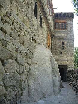
Skardu Fort (Kharphocho Fort)

Skardu Fort or Kharphocho Fort lies on the eastern face of the Khardrong or Mindoq-Khar ("Castle of Queen Mindoq") hill 15 metres or 40 feet (12 m) above Skardu town. The fort dates from the 8th century CE and contains an old mosque probably dating back to the arrival of Islam in the 16th century CE. The fort provides a panoramic view of Skardu town, the Skardu valley and the Indus River. It was built by Maqpon dynasty rulers of Baltistan. It was a seven-storey building. Mostly local people say that Kharpoocho is made by a ghost as they were servants of the ruler of that time.
Kharphocho (Skardu) fort was built on a design similar to that of Leh Palace and the Potala Palace in Lhasa, Tibet. The name Kharpochhe means the great fort — Khar in Tibetan means castle or fort and Chhe means great.
Shigar Fort
Located on the route to the world’s second highest mountain, K-2, is Shigar Fort. It is also known as Fong-Khar, which in the local language means the “Palace on the Rock”. The complex at Shigar comprises the 400-year-old fort/palace and two more recent buildings: the "Old House" and the "Garden House". The former palace of the Raja of Shigar has been transformed into a 20-room heritage guesthouse, with the grand audience hall serving as a museum of Balti culture and featuring select examples of fine wood-carvings, as well as other heritage objects.
Lakes near Skardu

There are three lakes in the vicinity of Skardu. In local Balti-Tibetan language, a lake is a thso or tso.
Kachura Lakes
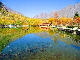
There are two Kachura lakes — the less well-known (Upper) Kachura Lake and the more famous Shangrila Lake ("Lower Kachura Lake"). Shangrila Lake is home to the Shangrila Resort hotel complex (possibly the reason for the lake's alternative name), built in a Chinese style and another popular destination for tourists in Azad Kashmir. The resort has a unique restaurant, set up inside the fuselage of an aircraft that crashed nearby. Kachura Lake is famous for its deep blue waters.
Satpara Lake
Satpara Lake is Skardu Valley's main lake. In 2002, the Federal Government decided to build a dam on the Satpara Lake allocating $10 million to the project, in 2004. Progress has, however, been slow. Satpara Lake is 6 miles (9.7 km) from Skardu. Satpara Lake is one of the largest fresh water lakes in the countryside offering trout fishing and row boating. This lake is the source of Skardu's drinking water. The dam was mostly completed in 2011 and four powerhouse units are operational; the latest started operation in June 2013.
See also
References
- ↑ Adle, Habib & Baipakov 2003, p. 245.
- ↑ Skardu, District. "Skardu District". www.skardu.pk. Skardu.pk. Retrieved 23 November 2016.
- ↑ "Vacations,Holiday,Travel,Climbing,Trekking". Skardu.pk. Retrieved 2015-09-06.
- 1 2 "Skardu Climate Data". web.archive.org. 2014. Archived from the original on 2010-06-13. Retrieved 18 February 2014.
- 1 2 "SATPARA DAM PROJECT Updated as". Wapda.gov.pk. Retrieved 2015-09-06.
- Bibliography
- Adle, Chahryar; Habib, Irfan; Baipakov, Karl Moldakhmetovich (1 January 2003). Development in Contrast: From the Sixteenth to the Mid-nineteenth Century. UNESCO. ISBN 978-92-3-103876-1.
- Petr, T. (1999). Fish and Fisheries at Higher Altitudes: Asia. Food & Agriculture Org. ISBN 978-92-5-104309-7.
Further reading
- Jettmar, Karl et al. (1985): Zwischen Gandhara und den Seidenstrassen: Felsbilder am Karakorum Highway: Entdeckungen deutsch-pakistanischer Expeditionen 1979-1984. 1985. Mainz am Rhein, Philipp von Zabern.
- Jettmar. Karl (1980): Bolor & Dardistan. Karl Jettmar. Islamabad, National Institute of Folk Heritage.
External links
| Wikimedia Commons has media related to Skardu. |
- http://www.skardu.pk
-
 Skardu travel guide from Wikivoyage